Bank nearby HSBC
United Kingdom
Bank nearby HSBC
HSBC
88 Town Street, Horsforth, West Yorkshire, Leeds Reino Unido
contacts phone
:
+44
Latitude:
53.8390528
, Longitude:
-1.6387077
read more
nearest Bank
39 m
Leeds Building Society
80 Town Street, Leeds
Bank
read more
72 m
Barclays Bank
68 Town Street, Horsforth, Leeds
Bank
read more
178 m
Santander
42 Town Street, Horsforth, Leeds
Bank
read more
195 m
Lloyds Bank
38 Town Street, Horsforth, Leeds
Bank
read more
207 m
Halifax
36 Town Street, Horsforth, Leeds
Bank
read more
221 m
Yorkshire Bank
32 Town Street, Horsforth, Leeds
Bank
read more
3.077 km
Yorkshire Bank
215 Town Street, Leeds
Bank
read more
3.099 km
Halifax
Bramley, 48 District Bramley, Leeds
Bank
read more
3.099 km
Halifax
48, Bramley District Centre, Bramley, Leeds
Bank
read more
4.22 km
Halifax
47 High Street, Yeadon, Leeds
Bank
read more
4.264 km
Santander
25 High Street, Yeadon, Leeds
Bank
read more
4.327 km
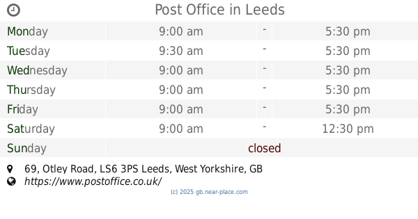
Post Office
3ps, 69 Otley Road, Leeds
Bank
read more
4.438 km
NatWest
63 Otley Road, Leeds
Bank
read more
4.451 km
Halifax
5 North Lane, Leeds
Bank
read more
4.451 km
Halifax
5 North Ln, Leeds
Bank
read more
4.541 km
M&S Bank Pudsey
Marks & Spencer Pudsey, The Owlcotes Centre, Varley Street, Stanningley
Bank
read more
4.964 km
Yorkshire Building Society
23 Lidget Hill, Pudsey
Bank
read more
4.992 km
HSBC Bank
West Yorkshire, Pudsey
Bank
read more
5.008 km
Yorkshire Bank
waver Green, Pudsey, Leeds
Bank
read more
5.035 km
Halifax
1 Market Pl, Pudsey
Bank
read more
5.103 km
Santander
33 Church Lane, Pudsey
Bank
read more
6.24 km
Barclays Bank
45 Oxford Road, Guiseley, Leeds
Bank
read more
6.241 km
Frank Parkinson Yorkshire Trust
Flat 26 Frankparkinson Court, Bingley Lands, Guiseley, Leeds
Bank
read more
6.46 km
Lloyds Bank
983 Leeds Road, West Yorkshire, Bradford
Bank
read more
6.46 km
Lloyds Bank
983 Leeds Road, Bradford
Bank
read more
📑
all categories
Accounting
Administrative area level 1
Administrative area level 2
Airport
Amusement park
Aquarium
Art gallery
Atm
Bakery
Bank
Bar
Beauty salon
Bicycle store
Book store
Bowling alley
Bus station
Cafe
Campground
Car dealer
Car rental
Car repair
Car wash
Casino
Cemetery
Church
City hall
Clothing store
Colloquial area
Convenience store
Courthouse
Dentist
Department store
Doctor
Electrician
Electronics store
Embassy
Establishment
Finance
Fire station
Florist
Food
Funeral home
Furniture store
Gas station
General contractor
Grocery or supermarket
Gym
Hair care
Hardware store
Health
Hindu Temple
Home goods store
Hospital
Insurance agency
Jewelry store
Laundry
Lawyer
Library
Light rail station
Liquor store
Local government office
Locality
Locksmith
Lodging
Meal delivery
Meal takeaway
Mosque
Movie rental
Movie theater
Moving company
Museum
Natural feature
Neighborhood
Night club
Painter
Park
Parking
Pet store
Pharmacy
Physiotherapist
Place of worship
Plumber
Point of interest
Police
Political
Post office
Premise
Real estate agency
Restaurant
Roofing contractor
Route
Rv park, camping
School
Shoe store
Shopping mall
Spa
Stadium
Storage
Store
Subpremise
Subway station
Supermarket
Synagogue
Taxi stand
Train station
Transit station
Travel agency
University
Veterinary care
Zoo
administrative area level 3
administrative area level 4
sublocality level 1
↑