Bank nearby Lloyds Bank
United Kingdom
Bank nearby Lloyds Bank
Lloyds Bank
8 Marylebone High Street, London United Kingdom
contacts phone
:
+44
Latitude:
51.5188552
, Longitude:
-0.1515119
read more
nearest Bank
12 m
NatWest
10 Marylebone High Street, London
Bank
read more
37 m
Barclays Bank
5a Marylebone High Street, London
Bank
read more
53 m
Halifax
116/, 7 Marylebone High Street, London
Bank
read more
113 m
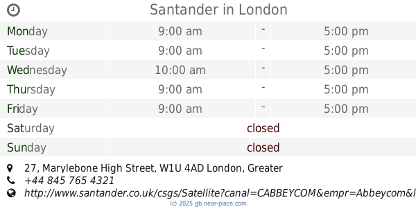
Santander
27 Marylebone High Street, London
Bank
read more
142 m
National Bank Of Kuwait
13 George Street, London
Bank
read more
314 m
BLME
12 Manchester Square, London
Bank
read more
318 m
TSB Bank
68 Baker Street, London
Bank
read more
379 m
National Bank Of Kuwait
7 Portman Square, London
Bank
read more
394 m
البنك الوطني لندن
6ld, 4 Portman Square, London
Bank
read more
410 m
NatWest Bank
1 Portman Square, London
Bank
read more
451 m
Al Rayan Bank
15 Stratford Place, London
Bank
read more
477 m
Aspinall Capital Advisors
Portman Towers, London
Bank
read more
574 m
HSBC
186 Baker Street, London
Bank
read more
589 m
Habib Allied International Bank PLC
9 Portman Street, London
Bank
read more
624 m
Halifax
20 North Audley Street, London
Bank
read more
753 m
Turkish Bank UK Ltd
41-43 Brook Street, London
Bank
read more
807 m
CX
4D Candover Street, London
Bank
read more
860 m
ATM (Regents College)
Inner Circle, London
Bank
read more
870 m
HSBC
196 Oxford Street, London
Bank
read more
931 m
DFA
20 Triton Street, London
Bank
read more
977 m
EFG Eurobank Ergasias SA
25 Berkeley Square, London
Bank
read more
1.034 km
LJ Resource Bank
The Montagu Centre, 21 Maple Street, London
Bank
read more
1.052 km
Bank Hapoalim
25 Savile Row, London
Bank
read more
1.121 km
TradeX Markets Ltd
8 Grafton Street, London
Bank
read more
1.321 km
Vontobel Europe
22 Sackville Street, London
Bank
read more
📑
all categories
Accounting
Administrative area level 1
Administrative area level 2
Airport
Amusement park
Aquarium
Art gallery
Atm
Bakery
Bank
Bar
Beauty salon
Bicycle store
Book store
Bowling alley
Bus station
Cafe
Campground
Car dealer
Car rental
Car repair
Car wash
Casino
Cemetery
Church
City hall
Clothing store
Colloquial area
Convenience store
Courthouse
Dentist
Department store
Doctor
Electrician
Electronics store
Embassy
Establishment
Finance
Fire station
Florist
Food
Funeral home
Furniture store
Gas station
General contractor
Grocery or supermarket
Gym
Hair care
Hardware store
Health
Hindu Temple
Home goods store
Hospital
Insurance agency
Jewelry store
Laundry
Lawyer
Library
Light rail station
Liquor store
Local government office
Locality
Locksmith
Lodging
Meal delivery
Meal takeaway
Mosque
Movie rental
Movie theater
Moving company
Museum
Natural feature
Neighborhood
Night club
Painter
Park
Parking
Pet store
Pharmacy
Physiotherapist
Place of worship
Plumber
Point of interest
Police
Political
Post office
Premise
Real estate agency
Restaurant
Roofing contractor
Route
Rv park, camping
School
Shoe store
Shopping mall
Spa
Stadium
Storage
Store
Subpremise
Subway station
Supermarket
Synagogue
Taxi stand
Train station
Transit station
Travel agency
University
Veterinary care
Zoo
administrative area level 3
administrative area level 4
sublocality level 1
↑