Bank nearby Societe Generale Private Banking Hambros
United Kingdom
Bank nearby Societe Generale Private Banking Hambros
Societe Generale Private Banking Hambros
8 Harewood Mews, Harewood, Leeds United Kingdom
contacts phone
:
+44
Latitude:
53.896777
, Longitude:
-1.533708
read more
nearest Bank
49 m
Societe Generale
8 Harewood Yard., HAREWOOD, Leeds, Leeds
Bank
read more
49 m
SG Kleinwort Hambros Bank Limited
8 Harewood Yard., HAREWOOD, Leeds, Leeds
Bank
read more
6.008 km
Leeds Building Society
475 Otley Road, Leeds
Bank
read more
8.753 km
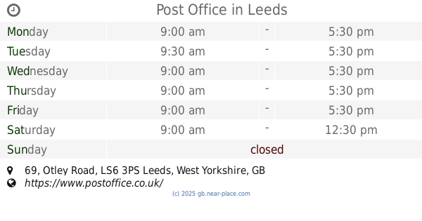
Post Office
3ps, 69 Otley Road, Leeds
Bank
read more
10.373 km
ATM
Clay Pit Lane, Leeds
Bank
read more
10.397 km
Halifax
47 High Street, Yeadon, Leeds
Bank
read more
10.588 km
Halifax
3/5 Kirkgate, Otley
Bank
read more
10.862 km
TSB Bank
119 The Headrow, Leeds
Bank
read more
10.927 km
RBS
27 Park Row, Leeds
Bank
read more
11.043 km
Halifax
18 King Edward Street, Leeds
Bank
read more
11.043 km
Halifax
18 King Edward St, Leeds
Bank
read more
11.107 km
Rothschild N M & Sons Ltd
1 Park Row, Leeds
Bank
read more
11.129 km
M&S Bank Leeds
47 Briggate, Leeds
Bank
read more
11.299 km
Brown Shipley
10 Wellington Place, Leeds
Bank
read more
11.363 km
Lloyds Bank
1, Cross Gates Centre, Leeds
Bank
read more
11.999 km
Barclays Bank
45 Oxford Road, Guiseley, Leeds
Bank
read more
12.029 km
ATM (Leeds City College)
123 Hunslet Road, Leeds
Bank
read more
15.168 km
Santander
273 Bradford Road, Bradford
Bank
read more
15.871 km
Lloyds Bank
983 Leeds Road, West Yorkshire, Bradford
Bank
read more
16.471 km
Santander
The Old School House, Wrose Brow Road, Shipley
Bank
read more
18.064 km
dillydinho
67 Leeds Road, Bradford
Bank
read more
18.318 km
Santander
2 Darley Street, Bradford
Bank
read more
18.333 km
HSBC
47 Market Street, Bradford
Bank
read more
18.336 km
Santander
50 Kirkgate, Bradford
Bank
read more
18.448 km
The Co-operative Bank
6 Tyrrel Street, Bradford
Bank
read more
📑
all categories
Accounting
Administrative area level 1
Administrative area level 2
Airport
Amusement park
Aquarium
Art gallery
Atm
Bakery
Bank
Bar
Beauty salon
Bicycle store
Book store
Bowling alley
Bus station
Cafe
Campground
Car dealer
Car rental
Car repair
Car wash
Casino
Cemetery
Church
City hall
Clothing store
Colloquial area
Convenience store
Courthouse
Dentist
Department store
Doctor
Electrician
Electronics store
Embassy
Establishment
Finance
Fire station
Florist
Food
Funeral home
Furniture store
Gas station
General contractor
Grocery or supermarket
Gym
Hair care
Hardware store
Health
Hindu Temple
Home goods store
Hospital
Insurance agency
Jewelry store
Laundry
Lawyer
Library
Light rail station
Liquor store
Local government office
Locality
Locksmith
Lodging
Meal delivery
Meal takeaway
Mosque
Movie rental
Movie theater
Moving company
Museum
Natural feature
Neighborhood
Night club
Painter
Park
Parking
Pet store
Pharmacy
Physiotherapist
Place of worship
Plumber
Point of interest
Police
Political
Post office
Premise
Real estate agency
Restaurant
Roofing contractor
Route
Rv park, camping
School
Shoe store
Shopping mall
Spa
Stadium
Storage
Store
Subpremise
Subway station
Supermarket
Synagogue
Taxi stand
Train station
Transit station
Travel agency
University
Veterinary care
Zoo
administrative area level 3
administrative area level 4
sublocality level 1
↑