Bar nearby Bridge End Inn
United Kingdom
Bar nearby Bridge End Inn
Bridge End Inn
Bedwas Vereinigtes Königreich
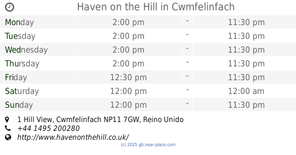
contacts phone
:
+44
Latitude:
51.5898574
, Longitude:
-3.1993211
read more
nearest Bar
4 m
Sports Bar
Caerphilly
Bar
read more
104 m
The Wonky Bar
17 Church Street, Bedwas, Caerphilly
Bar
read more
167 m
Fishermans Rest Inn
Old, Bedwas Road, Caerphilly
Bar
read more
394 m
The Bridge Inn
56 Church Street, Bedwas, Caerphilly
Bar
read more
615 m
The Church House Inn
Church Street, Bedwas, Caerphilly
Bar
read more
747 m
The Crossways
Parc Pontypandy, Caerphilly
Bar
read more
757 m
Brewers Fayre Crossways
Crossways Business Park, Pontypandy, Caerphilly
Bar
read more
1.144 km
Ruperra sports and social club
Navigation Street, Trethomas, Caerphilly
Bar
read more
1.548 km
The Green Lady
Pontygwindy Road, Caerphilly
Bar
read more
1.626 km
Pontygwindy
Pontygwindy Road, Caerphilly
Bar
read more
1.818 km
Piccadilly Inn
Piccadilly Square, Caerphilly
Bar
read more
1.905 km
Caerphilly Social Club & Institute Ltd
44 Castle Street, Caerphilly
Bar
read more
1.939 km
Allstar Mobile Bar Hire Wales
Van Road, Caerphilly
Bar
read more
2.069 km
Masons Arms
Mill Road, Caerphilly
Bar
read more
2.22 km
Court House
Cardiff Road, Caerphilly
Bar
read more
2.22 km
91 Floyd's Place
99 Bartlett Street, Caerphilly
Bar
read more
2.316 km
Kings Arms
46 Cardiff Road, Caerphilly
Bar
read more
2.39 km
The Caerphilly Cwtch
Station Terrace, Caerphilly
Bar
read more
2.392 km
Caerphilly Cwtch
Station Terrace, Caerphilly
Bar
read more
3.003 km
The Moat House Hotel
30 Lon-Y-Llyn, Caerphilly
Bar
read more
3.128 km
Angel Bar & Grill
White Cross Lane, Hendredenny, Caerphilly
Bar
read more
3.338 km
Forestier Walker Conservative Club
Islwyn Street, Cwmfelinfach, Newport
Bar
read more
3.463 km
Haven on the Hill
1 Hill View, Cwmfelinfach
Bar
read more
3.669 km
Cwrt Rawlin
Cyn Farm Estate, Caerphilly
Bar
read more
6.839 km
Taffs Well Ex-Service & Social Club
Cardiff Road, Taff's Well, Cardiff
Bar
read more
📑
all categories
Accounting
Administrative area level 1
Administrative area level 2
Airport
Amusement park
Aquarium
Art gallery
Atm
Bakery
Bank
Bar
Beauty salon
Bicycle store
Book store
Bowling alley
Bus station
Cafe
Campground
Car dealer
Car rental
Car repair
Car wash
Casino
Cemetery
Church
City hall
Clothing store
Colloquial area
Convenience store
Courthouse
Dentist
Department store
Doctor
Electrician
Electronics store
Embassy
Establishment
Finance
Fire station
Florist
Food
Funeral home
Furniture store
Gas station
General contractor
Grocery or supermarket
Gym
Hair care
Hardware store
Health
Hindu Temple
Home goods store
Hospital
Insurance agency
Jewelry store
Laundry
Lawyer
Library
Light rail station
Liquor store
Local government office
Locality
Locksmith
Lodging
Meal delivery
Meal takeaway
Mosque
Movie rental
Movie theater
Moving company
Museum
Natural feature
Neighborhood
Night club
Painter
Park
Parking
Pet store
Pharmacy
Physiotherapist
Place of worship
Plumber
Point of interest
Police
Political
Post office
Premise
Real estate agency
Restaurant
Roofing contractor
Route
Rv park, camping
School
Shoe store
Shopping mall
Spa
Stadium
Storage
Store
Subpremise
Subway station
Supermarket
Synagogue
Taxi stand
Train station
Transit station
Travel agency
University
Veterinary care
Zoo
administrative area level 3
administrative area level 4
sublocality level 1
↑