Bar nearby Cross Keys Hotel
United Kingdom
Bar nearby Cross Keys Hotel
Cross Keys Hotel
High Street, Newport Vereinigtes Königreich
contacts phone
:
+44
Latitude:
51.621823
, Longitude:
-3.1275165
read more
nearest Bar
183 m
Cross Keys Silver Band
A467 Crosskeys Newport, Monmouthshire NP11 7
Bar
read more
782 m
The Philanthropic Inn
22 Twyncarn Road, Crosskeys, Newport
Bar
read more
868 m
The Castle Lodge Bed and Breakfast
Twyncarn Road, Pontywaun, Cwmcarn, Newport
Bar
read more
1.439 km
Cwmcarn Working Mens Club & Institute
71-72 Newport Road, Cwmcarn, Newport
Bar
read more
1.592 km
The Cwmcarn Hotel
Newport Road, Cwmcarn, Caerphilly
Bar
read more
1.652 km
Darran
2 Saint Mary Street, Risca
Bar
read more
1.88 km
Exchange Inn
52 Saint Mary Street, Risca, Newport
Bar
read more
2.328 km
Railway Tavern
1 Dan Y Graig Road, Newport
Bar
read more
2.517 km
The Fox & Hounds
Park Road, Newport NP11 6PW
Bar
read more
2.573 km
The NEW INN
1, Commercial Road, Abercarn
Bar
read more
2.576 km
The RHYSWG
1, Commercial Road, Abercarn
Bar
read more
2.92 km
Commercial Inn
3 High Street, Abercarn, Newport
Bar
read more
3.11 km
Masons Arms
9 Mill Terrace, Risca, Newport
Bar
read more
3.115 km
The Rolling Mill
United Kingdom
Bar
read more
3.26 km
Crown Inn
3 Dan-Y-Rhiw Terrace, Abercarn, Newport
Bar
read more
3.27 km
The Grove
106A Commercial Street, Risca, Newport
Bar
read more
3.32 km
The Church Inn
Cwmfelinfach, Blackwood
Bar
read more
3.378 km
White Hart Inn
White Hart, Machen, Caerphilly, CF83 8QQ
Bar
read more
3.393 km
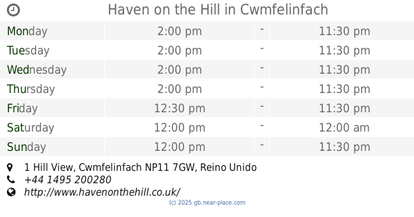
Haven on the Hill
1 Hill View, Cwmfelinfach
Bar
read more
4.577 km
Otter
Bridge Street, Newbridge
Bar
read more
4.97 km
The Red Lion
27 Bryngwyn Road, Newbridge, Newport
Bar
read more
4.977 km
The Dorallt Inn
Henllys, Cwmbran
Bar
read more
5.239 km
The Halfway House
Upper Gelligroes, Blackwood
Bar
read more
6.624 km
The Friendly Fox
33 Caerphilly Rd, Bassaleg, Newport
Bar
read more
6.823 km
The New Foresters
110 High Street, Blackwood
Bar
read more
📑
all categories
Accounting
Administrative area level 1
Administrative area level 2
Airport
Amusement park
Aquarium
Art gallery
Atm
Bakery
Bank
Bar
Beauty salon
Bicycle store
Book store
Bowling alley
Bus station
Cafe
Campground
Car dealer
Car rental
Car repair
Car wash
Casino
Cemetery
Church
City hall
Clothing store
Colloquial area
Convenience store
Courthouse
Dentist
Department store
Doctor
Electrician
Electronics store
Embassy
Establishment
Finance
Fire station
Florist
Food
Funeral home
Furniture store
Gas station
General contractor
Grocery or supermarket
Gym
Hair care
Hardware store
Health
Hindu Temple
Home goods store
Hospital
Insurance agency
Jewelry store
Laundry
Lawyer
Library
Light rail station
Liquor store
Local government office
Locality
Locksmith
Lodging
Meal delivery
Meal takeaway
Mosque
Movie rental
Movie theater
Moving company
Museum
Natural feature
Neighborhood
Night club
Painter
Park
Parking
Pet store
Pharmacy
Physiotherapist
Place of worship
Plumber
Point of interest
Police
Political
Post office
Premise
Real estate agency
Restaurant
Roofing contractor
Route
Rv park, camping
School
Shoe store
Shopping mall
Spa
Stadium
Storage
Store
Subpremise
Subway station
Supermarket
Synagogue
Taxi stand
Train station
Transit station
Travel agency
University
Veterinary care
Zoo
administrative area level 3
administrative area level 4
sublocality level 1
↑