Bar nearby Doctors Tonic
United Kingdom
Bar nearby Doctors Tonic
Doctors Tonic
Church Road, Welwyn Garden City Vereinigtes Königreich
contacts phone
:
+44
Latitude:
51.7999607
, Longitude:
-0.2077121
read more
nearest Bar
806 m
The Stanborough - Whitbread Plc
Stanborough Road, Welwyn Garden City
Bar
read more
822 m
Beefeater Stanborough
Stanborough Road, Welwyn Garden City
Bar
read more
1.576 km
The Chieftain
Cole Green Lane, Welwyn Garden City
Bar
read more
3.374 km
Hopfields
Homestead Rd, Hatfield
Bar
read more
3.745 km
George's Fish Bar
6 Saint Albans Road East, Hatfield
Bar
read more
3.757 km
Red Lion
88 Great North Road, Hatfield, Hertfordshire, Hatfield
Bar
read more
3.883 km
Brewers Fayre Airfield
Comet Way, Lemsford, Comet Way
Bar
read more
3.883 km
Brewers Fayre
The Airfield, Lemsford Road, Hatfield
Bar
read more
3.883 km
Table Table
The Airfield, Lemsford Road, Hatfield
Bar
read more
4.072 km
The Great Northern Pub
54 Great North Road, Hatfield
Bar
read more
4.113 km
Horse & Groom
21 Park Street, Hatfield
Bar
read more
4.186 km
The Eight Bells
2 Park Street, Hatfield
Bar
read more
4.317 km
The Town Inn
Queensway, Hatfield
Bar
read more
4.549 km
Roti House
12 Harpsfield Broadway, Hatfield
Bar
read more
4.611 km
Bat Turan Indian and Nepalese Restaurant
2 Parkhouse Court, Hatfield
Bar
read more
4.611 km
Bar Turan Indian and Nepalese Restaurant
2 Parkhouse Court, Hatfield
Bar
read more
4.739 km
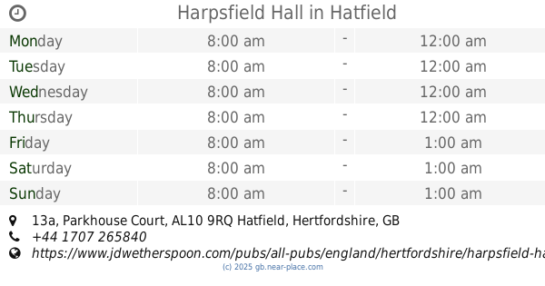
Harpsfield Hall
13a Parkhouse Court, Hatfield
Bar
read more
4.742 km
Wetherspoons, Hatfield
13a Parkhouse Court, Hatfield
Bar
read more
4.792 km
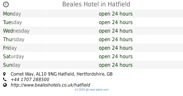
Beales Hotel
Comet Way, Hatfield
Bar
read more
4.834 km
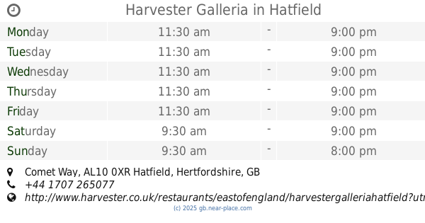
Harvester Galleria
63A, Comet Way, Hatfield
Bar
read more
4.874 km
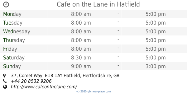
Cafe on the Lane
The Galleria, 37 Comet Way, London
Bar
read more
5.195 km
cavendish arms
The Cavendish Arms, 19 Bishops Rise, Hatfield
Bar
read more
5.323 km
Club de Havilland
Hatfield Business Park, Mosquito Way, Hatfield
Bar
read more
6.44 km
The Three Horseshoes
612 Hatfield Road, St Albans
Bar
read more
9.563 km
Harvester
46 Harpenden Road, St Albans
Bar
read more
📑
all categories
Accounting
Administrative area level 1
Administrative area level 2
Airport
Amusement park
Aquarium
Art gallery
Atm
Bakery
Bank
Bar
Beauty salon
Bicycle store
Book store
Bowling alley
Bus station
Cafe
Campground
Car dealer
Car rental
Car repair
Car wash
Casino
Cemetery
Church
City hall
Clothing store
Colloquial area
Convenience store
Courthouse
Dentist
Department store
Doctor
Electrician
Electronics store
Embassy
Establishment
Finance
Fire station
Florist
Food
Funeral home
Furniture store
Gas station
General contractor
Grocery or supermarket
Gym
Hair care
Hardware store
Health
Hindu Temple
Home goods store
Hospital
Insurance agency
Jewelry store
Laundry
Lawyer
Library
Light rail station
Liquor store
Local government office
Locality
Locksmith
Lodging
Meal delivery
Meal takeaway
Mosque
Movie rental
Movie theater
Moving company
Museum
Natural feature
Neighborhood
Night club
Painter
Park
Parking
Pet store
Pharmacy
Physiotherapist
Place of worship
Plumber
Point of interest
Police
Political
Post office
Premise
Real estate agency
Restaurant
Roofing contractor
Route
Rv park, camping
School
Shoe store
Shopping mall
Spa
Stadium
Storage
Store
Subpremise
Subway station
Supermarket
Synagogue
Taxi stand
Train station
Transit station
Travel agency
University
Veterinary care
Zoo
administrative area level 3
administrative area level 4
sublocality level 1
↑