Bar nearby Ship Inn
United Kingdom
Bar nearby Ship Inn
Ship Inn
Hendresythan Road, Pontypridd Det Forenede Kongerige
contacts phone
:
+44
Latitude:
51.5501862
, Longitude:
-3.3357267
read more
nearest Bar
615 m
The Crown Inn
Main Road, Llantwit Fardre, Pontypridd
Bar
read more
980 m
The New Inn
Llantrisant Road, Pontypridd
Bar
read more
2.407 km
Cross Inn
Main Road, Cross Inn, Llantrisant
Bar
read more
2.746 km
Cross Keys Hotel
High Street, Llantrisant, Pontyclun
Bar
read more
2.784 km
The Wheatsheaf Hotel
High Street, Llantrisant, Pontyclun
Bar
read more
2.805 km
Bear Inn
Heol-Y-Sarn, Llantrisant, Pontyclun
Bar
read more
3.386 km
Harvester Talbot Green
Talbot Green Shopping Park, Talbot Road, Talbot Green, Pontyclun
Bar
read more
3.393 km
Lewis Arms
Heol Goch, Cardiff
Bar
read more
3.509 km
The Three Saints Hotel
Llantrisant Business Park, Llantrisant, South Wales
Bar
read more
3.519 km
Saints Bar & Carvery
The Three Saints Hotel, Pontyclun
Bar
read more
3.709 km
Beefeater Longbow
Magden Park, Gwaun Elai, Llantrisant
Bar
read more
3.779 km
Trattoria restaurant & Gin Bar
9-11 Talbot Road, Talbot Green, Pontyclun
Bar
read more
3.779 km
Trattoria Gin Bar
9-11 Talbot Road, Talbot Green, Pontyclun
Bar
read more
3.798 km
The Talbot Arms
1 Talbot Road, Pontyclun
Bar
read more
3.874 km
Kings Arms
Church Road, Cardiff
Bar
read more
3.974 km
The Pottery
Powys Road, Pontypridd
Bar
read more
4.084 km
Gwaelod-y-Garth Inn
Main Road, Gwaelod-y-Garth, Cardiff
Bar
read more
4.11 km
The Upper Boat Inn
Williams Place, Upper Boat, Pontypridd
Bar
read more
4.449 km
Taffs Well Ex-Service & Social Club
Cardiff Road, Taff's Well, Cardiff
Bar
read more
4.463 km
The Swan Inn
68 Cardiff Road, Creigiau, Cardiff
Bar
read more
4.789 km
The Windsor.
Llantrisant Road, Pontyclun
Bar
read more
4.817 km
Brunel Arms
Station Approach, Pontyclun
Bar
read more
8.358 km
Masons Arms
Mill Road, Caerphilly
Bar
read more
8.997 km
The Plough
1 Merthyr Road, Cardiff
Bar
read more
13.322 km
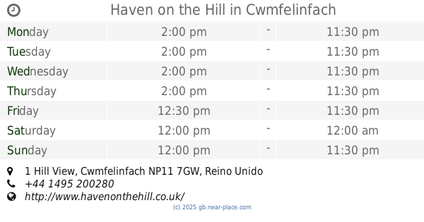
Haven on the Hill
1 Hill View, Cwmfelinfach
Bar
read more
📑
all categories
Accounting
Administrative area level 1
Administrative area level 2
Airport
Amusement park
Aquarium
Art gallery
Atm
Bakery
Bank
Bar
Beauty salon
Bicycle store
Book store
Bowling alley
Bus station
Cafe
Campground
Car dealer
Car rental
Car repair
Car wash
Casino
Cemetery
Church
City hall
Clothing store
Colloquial area
Convenience store
Courthouse
Dentist
Department store
Doctor
Electrician
Electronics store
Embassy
Establishment
Finance
Fire station
Florist
Food
Funeral home
Furniture store
Gas station
General contractor
Grocery or supermarket
Gym
Hair care
Hardware store
Health
Hindu Temple
Home goods store
Hospital
Insurance agency
Jewelry store
Laundry
Lawyer
Library
Light rail station
Liquor store
Local government office
Locality
Locksmith
Lodging
Meal delivery
Meal takeaway
Mosque
Movie rental
Movie theater
Moving company
Museum
Natural feature
Neighborhood
Night club
Painter
Park
Parking
Pet store
Pharmacy
Physiotherapist
Place of worship
Plumber
Point of interest
Police
Political
Post office
Premise
Real estate agency
Restaurant
Roofing contractor
Route
Rv park, camping
School
Shoe store
Shopping mall
Spa
Stadium
Storage
Store
Subpremise
Subway station
Supermarket
Synagogue
Taxi stand
Train station
Transit station
Travel agency
University
Veterinary care
Zoo
administrative area level 3
administrative area level 4
sublocality level 1
↑