Bar nearby The Bugle Hotel
United Kingdom
Bar nearby The Bugle Hotel
The Bugle Hotel
The Square, Fareham Vereinigtes Königreich
contacts phone
:
+44
Latitude:
50.849335
, Longitude:
-1.234171
read more
nearest Bar
841 m
Fisherman's Rest
Mill Lane, Titchfield
Bar
read more
1.604 km
Beefeater Oast & Squire
Peak Lane, The Avenue, Fareham
Bar
read more
1.68 km
The Sir Joseph Paxton
272 Hunts Pond Road, Fareham
Bar
read more
1.737 km
McCoys Pub Brokers Limited
25 Barnes Wallis Road, Segensworth East, Fareham
Bar
read more
1.894 km
The Heathfield Arms
116 Blackbrook Road, Fareham
Bar
read more
2.789 km
The Buccaneer Harvester
14 The Avenue, Fareham
Bar
read more
2.791 km
Harvester
14 The Avenue, Fareham
Bar
read more
3.128 km
Goughy’s Stag
Fleet End Bottom, Southampton
Bar
read more
3.202 km
Strawberry Field Tavern
Locks Heath Centre, 1, Centre Way, Southampton
Bar
read more
3.258 km
The Talisman
3 Bridge Road, Park Gate, Southampton
Bar
read more
3.316 km
The Miner's Arms
Miners Arms, 112 Funtley Road, Fareham
Bar
read more
3.481 km
Doom Bar
Duncan Road, Southampton
Bar
read more
3.577 km
Parsons Collar
Rookery Avenue, Whiteley, Fareham
Bar
read more
3.805 km
The Village Inn
Village Inn, Botley Road, Southampton
Bar
read more
4.059 km
Crown Inn
40 West Street, Fareham
Bar
read more
4.105 km
Harvester Whiteley
Whiteley Way, Fareham
Bar
read more
4.144 km
Antonio's
20 West Street, Fareham
Bar
read more
4.234 km
Sarisbury Green Social Club
108 Bridge Road, Sarisbury Green, Southampton
Bar
read more
4.281 km
The Golden Lion
High Street, Fareham
Bar
read more
4.556 km
The Elm Tree Inn - Swanwick
1 Swanwick Lane, Southampton
Bar
read more
4.615 km
The Ferryman
2 Warsash Road, Warsash, Southampton
Bar
read more
5.632 km
The Old Ship
261 Bridge Road, Southampton
Bar
read more
5.962 km
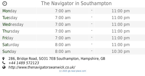
The Navigator
286 Bridge Road, Southampton
Bar
read more
6.016 km
Ideal Leisure
Swanwick Marina, Swanwick Shore, Southampton
Bar
read more
6.105 km
The Jolly Sailor
Lands End Road, Bursledon, Southampton
Bar
read more
📑
all categories
Accounting
Administrative area level 1
Administrative area level 2
Airport
Amusement park
Aquarium
Art gallery
Atm
Bakery
Bank
Bar
Beauty salon
Bicycle store
Book store
Bowling alley
Bus station
Cafe
Campground
Car dealer
Car rental
Car repair
Car wash
Casino
Cemetery
Church
City hall
Clothing store
Colloquial area
Convenience store
Courthouse
Dentist
Department store
Doctor
Electrician
Electronics store
Embassy
Establishment
Finance
Fire station
Florist
Food
Funeral home
Furniture store
Gas station
General contractor
Grocery or supermarket
Gym
Hair care
Hardware store
Health
Hindu Temple
Home goods store
Hospital
Insurance agency
Jewelry store
Laundry
Lawyer
Library
Light rail station
Liquor store
Local government office
Locality
Locksmith
Lodging
Meal delivery
Meal takeaway
Mosque
Movie rental
Movie theater
Moving company
Museum
Natural feature
Neighborhood
Night club
Painter
Park
Parking
Pet store
Pharmacy
Physiotherapist
Place of worship
Plumber
Point of interest
Police
Political
Post office
Premise
Real estate agency
Restaurant
Roofing contractor
Route
Rv park, camping
School
Shoe store
Shopping mall
Spa
Stadium
Storage
Store
Subpremise
Subway station
Supermarket
Synagogue
Taxi stand
Train station
Transit station
Travel agency
University
Veterinary care
Zoo
administrative area level 3
administrative area level 4
sublocality level 1
↑