Bar nearby The Fox Inn
United Kingdom
Bar nearby The Fox Inn
The Fox Inn
Broadwell, Moreton-in-Marsh Det Forenede Kongerige
contacts phone
:
+44
Latitude:
51.9451174
, Longitude:
-1.7059079
read more
nearest Bar
1.977 km
The White Hart
The Square, Market Square, Stow-on-the-Wold
Bar
read more
1.997 km
Queens Head Inn
Market Square, Stow-on-the-Wold, Cheltenham
Bar
read more
2.023 km
The Kings Arms
Market Square, Stow-on-the-Wold, Cheltenham
Bar
read more
2.027 km
The Bell at Stow
Park Street, Stow on the Wold
Bar
read more
2.035 km
The Porch House
Digbeth Street, Stow-on-the-Wold, Cheltenham
Bar
read more
2.049 km
Old Butchers
7 Park Street, Stow-on-the-Wold, Cheltenham
Bar
read more
2.058 km
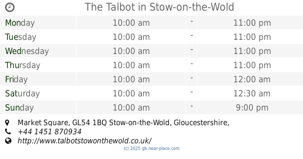
The Talbot
The Square, Market Square, Stow-on-the-Wold, Cheltenham
Bar
read more
2.096 km
Stow Lodge Hotel
The Square, Stow-on-the-Wold, Cheltenham
Bar
read more
2.606 km
Horse & Groom Village Inn
Moreton-in-Marsh
Bar
read more
2.619 km
The Horse & Groom
Upper Oddington, Moreton-in-Marsh
Bar
read more
3.275 km
The Coach & Horses Inn
Yew Tree Bank, Longborough
Bar
read more
3.307 km
The Fox at Oddington
high street, lower oddington
Bar
read more
3.385 km
The Golden Ball Inn
Lower Swell, Cheltenham
Bar
read more
3.386 km
Number Four at Stow - Hotel & Restaurant
Fosse Way, Stow-on-the-Wold, Cheltenham
Bar
read more
6.171 km
The Kings Head Inn
The Green, Chipping Norton
Bar
read more
6.184 km
The Slaughters Country Inn
Lower Slaughter, Cheltenham
Bar
read more
8.569 km
The Chequers
Church Road, Chipping Norton
Bar
read more
9.412 km
The Merrymouth Inn
Stow Road, Fifield, Chipping Norton
Bar
read more
12.485 km
The Lamb Inn
High Street, Shipton-under-Wychwood, Oxfordshire
Bar
read more
12.768 km
The Volunteer Inn B&B
Lower High Street, Chipping Campden
Bar
read more
12.82 km
Michael's Mediterranean Restaurant
High St, Chipping Campden
Bar
read more
15.36 km
The New Inn
The New Inn, Main Street,, Broadway
Bar
read more
15.521 km
The Bell Inn
Main Street, Willersey, Broadway
Bar
read more
15.523 km
The Carpenters Arms
Fulbrook Hill, A361, Fulbrook, Burford
Bar
read more
18.136 km
The Wykham Arms
Sibford Gower, Banbury
Bar
read more
📑
all categories
Accounting
Administrative area level 1
Administrative area level 2
Airport
Amusement park
Aquarium
Art gallery
Atm
Bakery
Bank
Bar
Beauty salon
Bicycle store
Book store
Bowling alley
Bus station
Cafe
Campground
Car dealer
Car rental
Car repair
Car wash
Casino
Cemetery
Church
City hall
Clothing store
Colloquial area
Convenience store
Courthouse
Dentist
Department store
Doctor
Electrician
Electronics store
Embassy
Establishment
Finance
Fire station
Florist
Food
Funeral home
Furniture store
Gas station
General contractor
Grocery or supermarket
Gym
Hair care
Hardware store
Health
Hindu Temple
Home goods store
Hospital
Insurance agency
Jewelry store
Laundry
Lawyer
Library
Light rail station
Liquor store
Local government office
Locality
Locksmith
Lodging
Meal delivery
Meal takeaway
Mosque
Movie rental
Movie theater
Moving company
Museum
Natural feature
Neighborhood
Night club
Painter
Park
Parking
Pet store
Pharmacy
Physiotherapist
Place of worship
Plumber
Point of interest
Police
Political
Post office
Premise
Real estate agency
Restaurant
Roofing contractor
Route
Rv park, camping
School
Shoe store
Shopping mall
Spa
Stadium
Storage
Store
Subpremise
Subway station
Supermarket
Synagogue
Taxi stand
Train station
Transit station
Travel agency
University
Veterinary care
Zoo
administrative area level 3
administrative area level 4
sublocality level 1
↑