Cafe nearby Cafe Fudge
Coronavirus disease (COVID-19) Situation
confirmed cases
24910387
deaths
232112
United Kingdom
Cafe nearby Cafe Fudge
Cafe Fudge
173 Park Road, Liverpool Det Forenede Kongerige
contacts phone
:
+44
Latitude:
53.3860003
, Longitude:
-2.9667051
read more
nearest Cafe
190 m
Tesco Café
215 Park Road, Liverpool
Cafe
read more
340 m
Rambos Cafe
North Hill Street, Liverpool
Cafe
read more
352 m
Cleo's Cafe
United Kingdom
Cafe
read more
531 m
Karls Coffe
150 Windsor Street, Liverpool
Cafe
read more
705 m
Costa Coffee
137 Sefton Street, Liverpool
Cafe
read more
852 m
Bean
104 Tower Street, Liverpool
Cafe
read more
885 m
Brunswick brunch bar
69 Sefton Street, Liverpool
Cafe
read more
975 m
L8 1TH
6 Princes Road, Liverpool
Cafe
read more
1.014 km
Café Mama's
United Kingdom
Cafe
read more
1.018 km
May's Thai Kitchen
58 Aigburth Road, Liverpool
Cafe
read more
1.116 km
ryde
The Courtyard, Cains Brewery Village, Stanhope Street, Liverpool
Cafe
read more
1.13 km
Sugar 'n' Slice
88 Aigburth Road, Liverpool
Cafe
read more
1.328 km
Safari Cafe
165 Lodge Lane, Liverpool
Cafe
read more
1.364 km
Unit 51
Baltic Creative, Jamaica Street, Liverpool
Cafe
read more
1.444 km
Green Days
13A Little Parkfield Road, Liverpool
Cafe
read more
1.495 km
Zorba Cafe
178 Aigburth Road, Liverpool
Cafe
read more
1.569 km
Blackburne House Cafe
3 Blackburne Place, Liverpool
Cafe
read more
1.75 km
92 Degrees Coffee
24 Hardman Street, Liverpool
Cafe
read more
1.848 km
Oasis in the Park
Sefton Park, Liverpool
Cafe
read more
1.897 km
Costa Coffee
Unit 3, Hope Street, Liverpool
Cafe
read more
2.014 km
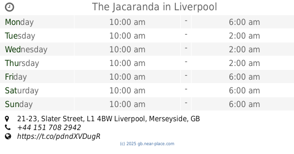
The Jacaranda
21-23 Slater Street, Liverpool
Cafe
read more
2.077 km
Red Kitchen
60 Wood Street, Liverpool
Cafe
read more
2.15 km
Greggs
21A Bold Street, Liverpool Chinatown, Liverpool
Cafe
read more
2.352 km
Starbucks Coffee
p28, Liverpool One, 2 Thomas Steers Way, Liverpool
Cafe
read more
2.419 km
Quayside Café
Ground Floor Merseyside Maritime Museum, Liverpool
Cafe
read more
📑
all categories
Accounting
Administrative area level 1
Administrative area level 2
Airport
Amusement park
Aquarium
Art gallery
Atm
Bakery
Bank
Bar
Beauty salon
Bicycle store
Book store
Bowling alley
Bus station
Cafe
Campground
Car dealer
Car rental
Car repair
Car wash
Casino
Cemetery
Church
City hall
Clothing store
Colloquial area
Convenience store
Courthouse
Dentist
Department store
Doctor
Electrician
Electronics store
Embassy
Establishment
Finance
Fire station
Florist
Food
Funeral home
Furniture store
Gas station
General contractor
Grocery or supermarket
Gym
Hair care
Hardware store
Health
Hindu Temple
Home goods store
Hospital
Insurance agency
Jewelry store
Laundry
Lawyer
Library
Light rail station
Liquor store
Local government office
Locality
Locksmith
Lodging
Meal delivery
Meal takeaway
Mosque
Movie rental
Movie theater
Moving company
Museum
Natural feature
Neighborhood
Night club
Painter
Park
Parking
Pet store
Pharmacy
Physiotherapist
Place of worship
Plumber
Point of interest
Police
Political
Post office
Premise
Real estate agency
Restaurant
Roofing contractor
Route
Rv park, camping
School
Shoe store
Shopping mall
Spa
Stadium
Storage
Store
Subpremise
Subway station
Supermarket
Synagogue
Taxi stand
Train station
Transit station
Travel agency
University
Veterinary care
Zoo
administrative area level 3
administrative area level 4
sublocality level 1
↑