Cafe nearby Café Maison
United Kingdom
Cafe nearby Café Maison
Café Maison
117A High Street, Stockton-on-Tees Det Forenede Kongerige
contacts phone
:
+44
Latitude:
54.5907925
, Longitude:
-1.3124072
read more
nearest Cafe
154 m
Pondview Tearoom and Convenience Store
71 High Street, Stockton-on-Tees
Cafe
read more
154 m
Pondview Tearoom and Convenience Store
71 High St, Stockton-on-Tees
Cafe
read more
379 m
Greggs Norton
51 High Street, Stockton-on-Tees
Cafe
read more
417 m
Costa
High Street, Stockton-on-Tees
Cafe
read more
419 m
Norton Cafe Restuarant
3-5 Maybray Kingwalk, Stockton-on-Tees
Cafe
read more
495 m
Costa Coffee
6 - 8 High Street, Stockton-on-Tees
Cafe
read more
821 m
383 Norton Road
383 Norton Road, Stockton-on-Tees
Cafe
read more
1.343 km
Our Village Cafe
United Kingdom
Cafe
read more
1.36 km
Taste Buds
45 Station Road, Billingham
Cafe
read more
1.398 km
Kays
18 Station Road, Billingham
Cafe
read more
1.924 km
P.J.B's Cafe And Takaway
122 Norton Road, Stockton-on-Tees
Cafe
read more
2.161 km
The Galleries
16-20 West Precinct, Billingham
Cafe
read more
2.215 km
Dj's Food Bar
154B Queensway, Billingham
Cafe
read more
2.243 km
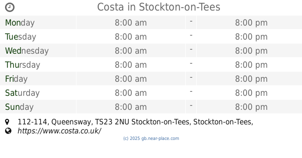
Costa
112-114 Queensway, Stockton-on-Tees, Billingham
Cafe
read more
2.261 km
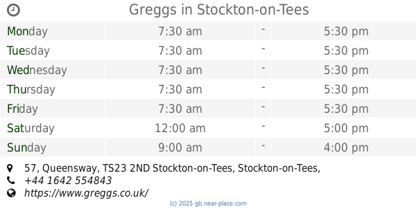
Greggs
57 Queensway, Billingham
Cafe
read more
2.291 km
The Bait Box
Ross Road, Stockton-on-Tees
Cafe
read more
2.293 km
Joanna's Kitchen
120 Queensway, Billingham
Cafe
read more
2.356 km
Atrium Café
United Kingdom
Cafe
read more
2.468 km
Cafe in The Park
Billingham, Stockton-on-Tees, Billingham
Cafe
read more
2.477 km
Greggs
11 Cheltenham Road, Stockton-on-Tees
Cafe
read more
2.607 km
Greggs Stockton High Newham
High Newham Road, Stockton-on-Tees
Cafe
read more
2.646 km
Tesco Café
Durham Road, Stockton-on-Tees
Cafe
read more
2.83 km
Greggs Wellington Square
34 Wellington St, Stockton on Tees
Cafe
read more
2.969 km
Wags & Whiskers Canine Cafe
6 Finkle Street, Stockton-on-Tees
Cafe
read more
2.97 km
Caffecino
37 Dovecot Street, Stockton-on-Tees
Cafe
read more
📑
all categories
Accounting
Administrative area level 1
Administrative area level 2
Airport
Amusement park
Aquarium
Art gallery
Atm
Bakery
Bank
Bar
Beauty salon
Bicycle store
Book store
Bowling alley
Bus station
Cafe
Campground
Car dealer
Car rental
Car repair
Car wash
Casino
Cemetery
Church
City hall
Clothing store
Colloquial area
Convenience store
Courthouse
Dentist
Department store
Doctor
Electrician
Electronics store
Embassy
Establishment
Finance
Fire station
Florist
Food
Funeral home
Furniture store
Gas station
General contractor
Grocery or supermarket
Gym
Hair care
Hardware store
Health
Hindu Temple
Home goods store
Hospital
Insurance agency
Jewelry store
Laundry
Lawyer
Library
Light rail station
Liquor store
Local government office
Locality
Locksmith
Lodging
Meal delivery
Meal takeaway
Mosque
Movie rental
Movie theater
Moving company
Museum
Natural feature
Neighborhood
Night club
Painter
Park
Parking
Pet store
Pharmacy
Physiotherapist
Place of worship
Plumber
Point of interest
Police
Political
Post office
Premise
Real estate agency
Restaurant
Roofing contractor
Route
Rv park, camping
School
Shoe store
Shopping mall
Spa
Stadium
Storage
Store
Subpremise
Subway station
Supermarket
Synagogue
Taxi stand
Train station
Transit station
Travel agency
University
Veterinary care
Zoo
administrative area level 3
administrative area level 4
sublocality level 1
↑