Cafe nearby Caramel
United Kingdom
Cafe nearby Caramel
Caramel
77 Wilton Road, London Reino Unido
contacts phone
:
+44
Latitude:
51.4927093
, Longitude:
-0.1403609
read more
nearest Cafe
110 m
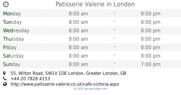
Patisserie Valerie
55 Wilton Road, London
Cafe
read more
110 m
Coffee Pepe Britainia
223 Vauxhall Bridge Road, London
Cafe
read more
182 m
The Roasting
31 Churton Street, London
Cafe
read more
373 m
Easy Coffee
Terminus Place, London
Cafe
read more
406 m
Cafe Rouge
Victoria Place Shopping Centre,, Buckingham Palace Road, London
Cafe
read more
481 m
Coffee and Bake
20, Colonnade Walk, 125 Buckingham Palace Road, London
Cafe
read more
485 m
Starbucks Coffee
Chantrey House, 98 Buckingham Palace Road, London
Cafe
read more
524 m
Caffè Nero
6 Wilcox Place, 105 Victoria Street, London
Cafe
read more
535 m
G’rilla
170-172 Victoria Street, London
Cafe
read more
540 m
Ole & Steen
1 Sir Simon Milton Square, Victoria, London
Cafe
read more
562 m
Cafe Fresco
10-11 Greycoat Place, London
Cafe
read more
564 m
Tomtom Mess Hall
14 Eccleston Street, London
Cafe
read more
573 m
Crosstown Victoria - Doughnuts & Coffee
14 Sir Simon Milton Square, London
Cafe
read more
581 m
Regency Cafe
17-19 Regency Street, London
Cafe
read more
599 m
Caffè Nero
6-9 Elizabeth Street, London
Cafe
read more
647 m
Pret A Manger
47 Strutton Ground, London
Cafe
read more
668 m
Greggs
12 Strutton Ground, London
Cafe
read more
689 m
Crussh
15 Strutton Ground, London
Cafe
read more
782 m
Relish
8 John Islip Street, London
Cafe
read more
809 m
Rag & Bone Coffee Co.
20 Great Peter Street, London
Cafe
read more
850 m
Starbucks Coffee
17 Broadway, London
Cafe
read more
874 m
Caffe Grana
55 Broadway, London
Cafe
read more
897 m
Pret A Manger
47 Great Peter Street, London
Cafe
read more
910 m
Members Room Tate Britain
Millbank, London
Cafe
read more
1.218 km
Waterfront London Vauxhall Restaurant
3 Saint George Wharf, London
Cafe
read more
📑
all categories
Accounting
Administrative area level 1
Administrative area level 2
Airport
Amusement park
Aquarium
Art gallery
Atm
Bakery
Bank
Bar
Beauty salon
Bicycle store
Book store
Bowling alley
Bus station
Cafe
Campground
Car dealer
Car rental
Car repair
Car wash
Casino
Cemetery
Church
City hall
Clothing store
Colloquial area
Convenience store
Courthouse
Dentist
Department store
Doctor
Electrician
Electronics store
Embassy
Establishment
Finance
Fire station
Florist
Food
Funeral home
Furniture store
Gas station
General contractor
Grocery or supermarket
Gym
Hair care
Hardware store
Health
Hindu Temple
Home goods store
Hospital
Insurance agency
Jewelry store
Laundry
Lawyer
Library
Light rail station
Liquor store
Local government office
Locality
Locksmith
Lodging
Meal delivery
Meal takeaway
Mosque
Movie rental
Movie theater
Moving company
Museum
Natural feature
Neighborhood
Night club
Painter
Park
Parking
Pet store
Pharmacy
Physiotherapist
Place of worship
Plumber
Point of interest
Police
Political
Post office
Premise
Real estate agency
Restaurant
Roofing contractor
Route
Rv park, camping
School
Shoe store
Shopping mall
Spa
Stadium
Storage
Store
Subpremise
Subway station
Supermarket
Synagogue
Taxi stand
Train station
Transit station
Travel agency
University
Veterinary care
Zoo
administrative area level 3
administrative area level 4
sublocality level 1
↑