Cafe nearby Coffee Plus
United Kingdom
Cafe nearby Coffee Plus
Coffee Plus
United Kingdom Det Forenede Kongerige
contacts phone
:
+44
Latitude:
53.8476298
, Longitude:
-2.9950987
read more
nearest Cafe
78 m
Costa Coffee
20-21 Teanlowe Centre, Poulton-le-Fylde
Cafe
read more
98 m
Costa Coffee
Unit 3 Village Walks Shopping Centre, Queensway, Poulton-le-Fylde
Cafe
read more
136 m
Alleyway Cafe
9A Church Street, Poulton-le-Fylde
Cafe
read more
222 m
Halo Coffee House
17 Ball Street, Poulton-le-Fylde
Cafe
read more
232 m
Truly Scrumptious
5 Chapel Street, Poulton-le-Fylde
Cafe
read more
248 m
tinderbox
29 Breck Road, Poulton-le-Fylde
Cafe
read more
250 m
The Corn Mill
1 Chapel Street, Poulton-le-Fylde
Cafe
read more
259 m
Boca Cafe Bar
6 Breck Road, Poulton-le-Fylde
Cafe
read more
313 m
Le Feast
Station platforms Poulton-Le-Fylde Station, Breck Road, Poulton-le-Fylde
Cafe
read more
1.473 km
Grafters
Unit 8, Cocker Avenue, Poulton Industrial Estate, Poulton-le-Fylde
Cafe
read more
2.168 km
Jude's 4 Food
107 Mowbray Drive, Blackpool
Cafe
read more
2.573 km
Mum's Cafe
United Kingdom
Cafe
read more
2.614 km
Fresh Sandwich & Breakfast Bar
99 Bispham Road, Blackpool
Cafe
read more
2.659 km
No 11 Sandwich Bar
11 Moor Park Avenue, Blackpool
Cafe
read more
2.679 km
SirDrakes Coffee Shop
Newton Hall Holiday Park, Staining RD, Staining, Blackpool
Cafe
read more
2.895 km
Loving Kindness Ltd
12 Blackpool Road, Blackpool
Cafe
read more
2.959 km
Bromleys
Victoria Rd, Cleveleys
Cafe
read more
3.274 km
Costa Coffee
Victoria Hospital, Whinney Heys Road, Blackpool
Cafe
read more
3.313 km
Sue's Curiositea & Coffee Shop
11-13 Layton Road, Blackpool
Cafe
read more
3.45 km
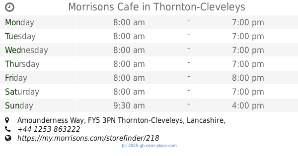
Morrisons Cafe
Amounderness Way
Cafe
read more
3.476 km
Morrisons Cafe
Amounderness Way, Thornton-Cleveleys
Cafe
read more
3.545 km
Country Hamper
438 Talbot Road, Blackpool
Cafe
read more
3.676 km
Hash Browns
United Kingdom
Cafe
read more
3.921 km
Costa Coffee
160 / 170 Devonshire Road, Blackpool
Cafe
read more
3.951 km
Costa Coffee
160/170 Devonshire Road, Blackpool
Cafe
read more
📑
all categories
Accounting
Administrative area level 1
Administrative area level 2
Airport
Amusement park
Aquarium
Art gallery
Atm
Bakery
Bank
Bar
Beauty salon
Bicycle store
Book store
Bowling alley
Bus station
Cafe
Campground
Car dealer
Car rental
Car repair
Car wash
Casino
Cemetery
Church
City hall
Clothing store
Colloquial area
Convenience store
Courthouse
Dentist
Department store
Doctor
Electrician
Electronics store
Embassy
Establishment
Finance
Fire station
Florist
Food
Funeral home
Furniture store
Gas station
General contractor
Grocery or supermarket
Gym
Hair care
Hardware store
Health
Hindu Temple
Home goods store
Hospital
Insurance agency
Jewelry store
Laundry
Lawyer
Library
Light rail station
Liquor store
Local government office
Locality
Locksmith
Lodging
Meal delivery
Meal takeaway
Mosque
Movie rental
Movie theater
Moving company
Museum
Natural feature
Neighborhood
Night club
Painter
Park
Parking
Pet store
Pharmacy
Physiotherapist
Place of worship
Plumber
Point of interest
Police
Political
Post office
Premise
Real estate agency
Restaurant
Roofing contractor
Route
Rv park, camping
School
Shoe store
Shopping mall
Spa
Stadium
Storage
Store
Subpremise
Subway station
Supermarket
Synagogue
Taxi stand
Train station
Transit station
Travel agency
University
Veterinary care
Zoo
administrative area level 3
administrative area level 4
sublocality level 1
↑