Cafe nearby Costa Coffee
United Kingdom
Cafe nearby Costa Coffee
Costa Coffee
Unit 3 The Foundation, Brownlow Hill, Liverpool United Kingdom
contacts phone
:
+44
Latitude:
53.4058794
, Longitude:
-2.9670974
read more
nearest Cafe
5 m
Greggs
9 Brownlow Hill, Liverpool
Cafe
read more
7 m
Costa Coffee
Brownlow Hill, Liverpool
Cafe
read more
75 m
Starbucks Coffee
Liverpool University Guild of Students, 160 Mount Pleasant, Liverpool
Cafe
read more
183 m
Caffè Nero
Crown Place, 200 Brownlow Hill, Liverpool
Cafe
read more
356 m
Costa Coffee
Unit 3, Hope Street, Liverpool
Cafe
read more
392 m
Cafe Marmalade
18 Pembroke Place, Liverpool
Cafe
read more
493 m
Costa Coffee Within Royal Liverpool Hospital
Prescot Street, Liverpool
Cafe
read more
494 m
Bee Bee's Cafe & Takeaway
138 London Road, Liverpool
Cafe
read more
562 m
92 Degrees Coffee
24 Hardman Street, Liverpool
Cafe
read more
658 m
Kane's Tea Room
23 Stafford Street, Liverpool
Cafe
read more
667 m
Costa Express
25 New Islington Road, Liverpool
Cafe
read more
696 m
Blackburne House Cafe
3 Blackburne Place, Liverpool
Cafe
read more
702 m
Costa Coffee
Unit 4 - Liverpool Lime Street Station, Liverpool
Cafe
read more
713 m
Layalina Shisha Lounge
51 London Road, Liverpool
Cafe
read more
853 m
Greggs
21A Bold Street, Liverpool Chinatown, Liverpool
Cafe
read more
864 m
Starbucks
21-23 Ranelagh Street, Liverpool
Cafe
read more
864 m
Starbucks Coffee
21-23 Ranelagh Street, Liverpool
Cafe
read more
870 m
Red Kitchen
60 Wood Street, Liverpool
Cafe
read more
873 m
Key Lime Coffee
178 Market Way, Liverpool
Cafe
read more
913 m
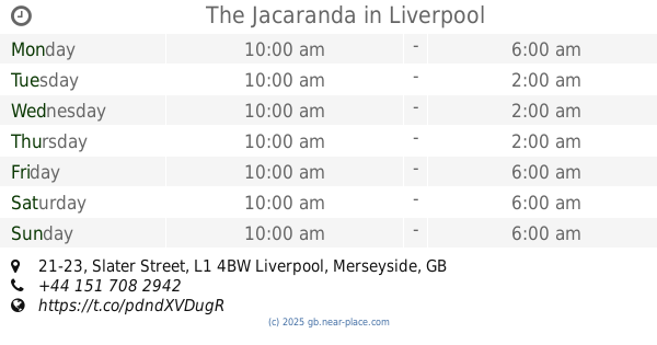
The Jacaranda
21-23 Slater Street, Liverpool
Cafe
read more
915 m
The Coffee Centre
139 St Johns Market, Liverpool
Cafe
read more
915 m
Bread & More
Saint George's Place, Liverpool
Cafe
read more
916 m
Bread & More
Liverpool
Cafe
read more
963 m
Gelatizmo
Ropewalks, Liverpool
Cafe
read more
1.164 km
Starbucks Coffee
Bryom Street, James Parson Building, Liverpool
Cafe
read more
📑
all categories
Accounting
Administrative area level 1
Administrative area level 2
Airport
Amusement park
Aquarium
Art gallery
Atm
Bakery
Bank
Bar
Beauty salon
Bicycle store
Book store
Bowling alley
Bus station
Cafe
Campground
Car dealer
Car rental
Car repair
Car wash
Casino
Cemetery
Church
City hall
Clothing store
Colloquial area
Convenience store
Courthouse
Dentist
Department store
Doctor
Electrician
Electronics store
Embassy
Establishment
Finance
Fire station
Florist
Food
Funeral home
Furniture store
Gas station
General contractor
Grocery or supermarket
Gym
Hair care
Hardware store
Health
Hindu Temple
Home goods store
Hospital
Insurance agency
Jewelry store
Laundry
Lawyer
Library
Light rail station
Liquor store
Local government office
Locality
Locksmith
Lodging
Meal delivery
Meal takeaway
Mosque
Movie rental
Movie theater
Moving company
Museum
Natural feature
Neighborhood
Night club
Painter
Park
Parking
Pet store
Pharmacy
Physiotherapist
Place of worship
Plumber
Point of interest
Police
Political
Post office
Premise
Real estate agency
Restaurant
Roofing contractor
Route
Rv park, camping
School
Shoe store
Shopping mall
Spa
Stadium
Storage
Store
Subpremise
Subway station
Supermarket
Synagogue
Taxi stand
Train station
Transit station
Travel agency
University
Veterinary care
Zoo
administrative area level 3
administrative area level 4
sublocality level 1
↑