Cafe nearby Tick Tock
United Kingdom
Cafe nearby Tick Tock
Tick Tock
3-5 Cowley Road, Oxford United Kingdom
contacts phone
:
+44
Latitude:
51.7498359
, Longitude:
-1.2435478
read more
nearest Cafe
49 m
Cafe Coco
23 Cowley Road, Oxford
Cafe
read more
55 m
Cous Cous Cafe
19-20 Saint Clement's Street, Oxford
Cafe
read more
267 m
Millefeuille
86 Cowley Road, Oxford
Cafe
read more
358 m
Percy's
The Old Music Hall, Cowley Road, Oxford
Cafe
read more
503 m
Refresh
131 Cowley Road, Oxford
Cafe
read more
550 m
The Grand Café
84 High Street, Oxford
Cafe
read more
568 m
Queen's Lane Coffee House
40 High Street, Oxford
Cafe
read more
607 m
Beetroot
166 Cowley Road, Oxford
Cafe
read more
785 m
Jericho Coffee Traders
105 High Street, Oxford
Cafe
read more
913 m
Cafe Loco
85-87 Saint Aldate's, Oxford
Cafe
read more
924 m
Whittard of Chelsea
15 High Street, Oxford
Cafe
read more
931 m
George & Danver
94 Saint Aldate's, Oxford
Cafe
read more
943 m
iScream Gelateria
113 The Covered Market Avenue 4, Market Street, Oxford
Cafe
read more
951 m
The Missing Bean
14 Turl Street, Oxford
Cafe
read more
967 m
terrace oxford
Covered Market, Oxford
Cafe
read more
972 m
Bodleian Library Café
Weston Library, Broad Street, Oxford
Cafe
read more
978 m
Sofi de France
33-36, Covered Market, Avenue 1 & 2, Oxford
Cafe
read more
996 m
Coba bubble tea
Golden Cross Walk, 9 Cornmarket Street, Oxford
Cafe
read more
1.008 km
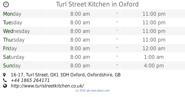
Turl Street Kitchen
16-17 Turl Street, Oxford
Cafe
read more
1.01 km
Jericho farmhouse kitchen
Oxford Road, Oakley, Hp189rg
Cafe
read more
1.025 km
Fernando's Cafe
Queens Street, Carfax Garden, Oxford
Cafe
read more
1.031 km
Magic Café
110 Magdalen Road, Oxford
Cafe
read more
1.047 km
Cafe Creme
19 Broad Street, Oxford
Cafe
read more
1.073 km
Bannisters
245 Iffley Road, Oxford
Cafe
read more
1.081 km
Percy's
247 Iffley Road, Oxford
Cafe
read more
📑
all categories
Accounting
Administrative area level 1
Administrative area level 2
Airport
Amusement park
Aquarium
Art gallery
Atm
Bakery
Bank
Bar
Beauty salon
Bicycle store
Book store
Bowling alley
Bus station
Cafe
Campground
Car dealer
Car rental
Car repair
Car wash
Casino
Cemetery
Church
City hall
Clothing store
Colloquial area
Convenience store
Courthouse
Dentist
Department store
Doctor
Electrician
Electronics store
Embassy
Establishment
Finance
Fire station
Florist
Food
Funeral home
Furniture store
Gas station
General contractor
Grocery or supermarket
Gym
Hair care
Hardware store
Health
Hindu Temple
Home goods store
Hospital
Insurance agency
Jewelry store
Laundry
Lawyer
Library
Light rail station
Liquor store
Local government office
Locality
Locksmith
Lodging
Meal delivery
Meal takeaway
Mosque
Movie rental
Movie theater
Moving company
Museum
Natural feature
Neighborhood
Night club
Painter
Park
Parking
Pet store
Pharmacy
Physiotherapist
Place of worship
Plumber
Point of interest
Police
Political
Post office
Premise
Real estate agency
Restaurant
Roofing contractor
Route
Rv park, camping
School
Shoe store
Shopping mall
Spa
Stadium
Storage
Store
Subpremise
Subway station
Supermarket
Synagogue
Taxi stand
Train station
Transit station
Travel agency
University
Veterinary care
Zoo
administrative area level 3
administrative area level 4
sublocality level 1
↑