Cafe nearby Viny's cafe
United Kingdom
Cafe nearby Viny's cafe
Viny's cafe
10 North Parade Avenue, Oxford United Kingdom
contacts phone
:
+44
Latitude:
51.7646211
, Longitude:
-1.261962
read more
nearest Cafe
18 m
International Cafe & Patisserie
13 North Parade Avenue, Oxford
Cafe
read more
57 m
Brew
75B Banbury Road, Oxford
Cafe
read more
545 m
Manos Fresh Food Bar
105 Walton Street, Oxford
Cafe
read more
553 m
Barefoot Jericho
74A Walton Street, Oxford
Cafe
read more
590 m
The Anchor
2 Hayfield Road, Oxford
Cafe
read more
635 m
Patisserie Valerie
3 Woodstock Road, Oxford
Cafe
read more
677 m
Cafe Rouge
11 Little Clarendon Street, Oxford
Cafe
read more
691 m
The Rickety Press
67 Cranham Street, Oxford
Cafe
read more
727 m
Common Ground
37-38 Little Clarendon Street, Oxford
Cafe
read more
744 m
Opera Cafe
31 Walton Street, Oxford
Cafe
read more
758 m
nero coffee, University of Oxford
Oxford
Cafe
read more
835 m
Greens Cafe
50 St Giles', Oxford
Cafe
read more
983 m
Ashmolean Rooftop Restaurant
Ashmolean Museum, Beaumont Street, Oxford
Cafe
read more
1.172 km
Caffè Nero
91 Gloucester Green, Oxford
Cafe
read more
1.184 km
Bodleian Library Café
Weston Library, Broad Street, Oxford
Cafe
read more
1.195 km
1738 Tea Room
Boswells, 1, 4 Broad Street, Oxford
Cafe
read more
1.243 km
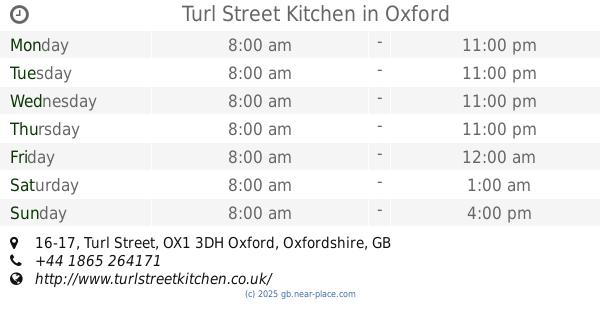
Turl Street Kitchen
16-17 Turl Street, Oxford
Cafe
read more
1.428 km
Whittard of Chelsea
15 High Street, Oxford
Cafe
read more
1.546 km
BRICK @ Modern Art Oxford
30 Pembroke Street, Oxford
Cafe
read more
1.547 km
Queen's Lane Coffee House
40 High Street, Oxford
Cafe
read more
1.606 km
George & Danver
94 Saint Aldate's, Oxford
Cafe
read more
1.608 km
Victors
Westgate Shopping Centre, Unit RU5, The Terrace, Bonn Square, Oxford
Cafe
read more
1.754 km
The Shake Lab
Westgate Oxford, Castle Street, Oxford
Cafe
read more
2.322 km
Millefeuille
86 Cowley Road, Oxford
Cafe
read more
2.406 km
Percy's
The Old Music Hall, Cowley Road, Oxford
Cafe
read more
📑
all categories
Accounting
Administrative area level 1
Administrative area level 2
Airport
Amusement park
Aquarium
Art gallery
Atm
Bakery
Bank
Bar
Beauty salon
Bicycle store
Book store
Bowling alley
Bus station
Cafe
Campground
Car dealer
Car rental
Car repair
Car wash
Casino
Cemetery
Church
City hall
Clothing store
Colloquial area
Convenience store
Courthouse
Dentist
Department store
Doctor
Electrician
Electronics store
Embassy
Establishment
Finance
Fire station
Florist
Food
Funeral home
Furniture store
Gas station
General contractor
Grocery or supermarket
Gym
Hair care
Hardware store
Health
Hindu Temple
Home goods store
Hospital
Insurance agency
Jewelry store
Laundry
Lawyer
Library
Light rail station
Liquor store
Local government office
Locality
Locksmith
Lodging
Meal delivery
Meal takeaway
Mosque
Movie rental
Movie theater
Moving company
Museum
Natural feature
Neighborhood
Night club
Painter
Park
Parking
Pet store
Pharmacy
Physiotherapist
Place of worship
Plumber
Point of interest
Police
Political
Post office
Premise
Real estate agency
Restaurant
Roofing contractor
Route
Rv park, camping
School
Shoe store
Shopping mall
Spa
Stadium
Storage
Store
Subpremise
Subway station
Supermarket
Synagogue
Taxi stand
Train station
Transit station
Travel agency
University
Veterinary care
Zoo
administrative area level 3
administrative area level 4
sublocality level 1
↑