Campground nearby Dadford Road Campsite & Parking
United Kingdom
Campground nearby Dadford Road Campsite & Parking
Dadford Road Campsite & Parking
Silverstone Road, Buckingham Reino Unido
contacts phone
:
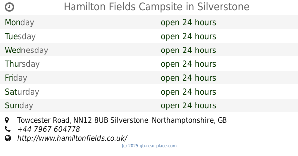
+44
Latitude:
52.0580975
, Longitude:
-1.0302909
read more
nearest Campground
8 m
Dadford Road Campsite & Parking
Dadford Road, Buckingham
Campground
read more
489 m
Silverstone Campsites
Silverstone Golf Club, Dadford Road, Silverstone, Buckingham
Campground
read more
512 m
Silverstone Woodlands Campsite
Biddlesden, Buckingham
Campground
read more
2.144 km
Private Camping at Litchlake Barns
Litchlake Barns, Buckingham Road, Silverstone
Campground
read more
2.999 km
Camping F1 British Grand Prix
Unnamed Road, Silverstone, Towcester
Campground
read more
3.958 km
Windmill Farm Campsite
14 Whittlebury Road, Silverstone, Towcester
Campground
read more
4.148 km
Silverstone Farm Campsite
New Rookery Farm, Little London, Silverstone
Campground
read more
4.514 km
Hamilton Fields Campsite
Towcester Road, Silverstone, Towcester
Campground
read more
5.408 km
Jubilee Barn - boutique glamping accommodation in northamptonshire near silverstone
Jubilee Barn,, Astwell, Helmdon
Campground
read more
5.565 km
Hilltop Cottage Campsite
Buckingham Road, Brackley
Campground
read more
10.557 km
Blakesley Leisure
7 High Street, Blakesley, Towcester
Campground
read more
18.19 km
The Pig Place
NB Acres, Aynho Rd, Adderbury, Banbury
Campground
read more
19.197 km
Bo Peep Farm
Aynho Road, Adderbury, Oxfordshire
Campground
read more
20.266 km
crossing farm camp site
1 The Twistle, Byfield, Daventry
Campground
read more
21.371 km
whitefeather campsite
Bunkers Hill, badby
Campground
read more
21.715 km
Barnstones Caravan Park
Main Street, Great Bourton, Oxfordshire OX17 1QU
Campground
read more
23.369 km
Grange farm
Mill Lane, Northampton
Campground
read more
23.802 km
CRD Logistics
75 The Stour, Daventry
Campground
read more
24.607 km
Ekeney House
Wood Farm, Emberton, Olney
Campground
read more
24.889 km
The Old Forge
Wroxton Lane, Horley, Banbury
Campground
read more
28.272 km
Napton Holt Farm Campsite
Holt Farm, Holt Road, Southam
Campground
read more
28.333 km
Doglane Fishery
Priors Marston Rd, Napton on the Hill, Southam
Campground
read more
29.582 km
Wigrams
Tomlow Rd, Southam
Campground
read more
31.2 km
Adkins N G & a C
Holt Farm/Welsh Rd East, Southam
Campground
read more
32.451 km
The Paddocks
Leamington Hastings, Rugby
Campground
read more
📑
all categories
Accounting
Administrative area level 1
Administrative area level 2
Airport
Amusement park
Aquarium
Art gallery
Atm
Bakery
Bank
Bar
Beauty salon
Bicycle store
Book store
Bowling alley
Bus station
Cafe
Campground
Car dealer
Car rental
Car repair
Car wash
Casino
Cemetery
Church
City hall
Clothing store
Colloquial area
Convenience store
Courthouse
Dentist
Department store
Doctor
Electrician
Electronics store
Embassy
Establishment
Finance
Fire station
Florist
Food
Funeral home
Furniture store
Gas station
General contractor
Grocery or supermarket
Gym
Hair care
Hardware store
Health
Hindu Temple
Home goods store
Hospital
Insurance agency
Jewelry store
Laundry
Lawyer
Library
Light rail station
Liquor store
Local government office
Locality
Locksmith
Lodging
Meal delivery
Meal takeaway
Mosque
Movie rental
Movie theater
Moving company
Museum
Natural feature
Neighborhood
Night club
Painter
Park
Parking
Pet store
Pharmacy
Physiotherapist
Place of worship
Plumber
Point of interest
Police
Political
Post office
Premise
Real estate agency
Restaurant
Roofing contractor
Route
Rv park, camping
School
Shoe store
Shopping mall
Spa
Stadium
Storage
Store
Subpremise
Subway station
Supermarket
Synagogue
Taxi stand
Train station
Transit station
Travel agency
University
Veterinary care
Zoo
administrative area level 3
administrative area level 4
sublocality level 1
↑