Campground nearby Donkey Creek Farm
United Kingdom
Campground nearby Donkey Creek Farm
Donkey Creek Farm
31 Naze Lane East, Freckleton, Preston United Kingdom
contacts phone
:
+44
Latitude:
53.747672
, Longitude:
-2.8620761
read more
nearest Campground
3.051 km
Sea View Caravan & Residential Home Park
Bank Lane, Warton
Campground
read more
3.637 km
Great Birchwood Campsite & Fisheries ( UNDER NEW MANAGEMENT 2017 )
Lytham Road, Warton, Preston
Campground
read more
3.823 km
The Spa Hotel
Ribby Hall Village, Ribby Road, Wrea Green, Preston
Campground
read more
4.326 km
Ribby Hall Village
Ribby Road, Preston
Campground
read more
4.326 km
Ribby Hall Village
Ribby Road, Kirkham, Preston
Campground
read more
4.99 km
Mowbreck Holiday and Residential Park
Mowbreck Lane, Wesham, Preston
Campground
read more
5.601 km
Lawnsdale Country Park
4 Lytham Road, Moss Side, Lytham Saint Annes
Campground
read more
6.539 km
Corner Hall Farm Campsite
Bradshaw Lane, Preston
Campground
read more
8.009 km
Moss Farm Cattery
Wham Lane, Preston
Campground
read more
8.23 km
Smithy Farm Shop
Fleetwood Road, Preston
Campground
read more
8.54 km
Ream Hills Holiday Park
Ream Hills Farm, Mythop Road, Preston
Campground
read more
10.009 km
Moss View Caravan Park
Bambers Lane, Blackpool
Campground
read more
10.076 km
Blackpool South Caravan and Motorhome Club Site
Blackpool South Club Site, Cropper Road, Marton, Blackpool, Lancashire
Campground
read more
10.076 km
Blackpool South Caravan and Motorhome Club Site
Marton, Cropper Road, Blackpool
Campground
read more
10.118 km
Chippendale parks
191 School Road, Blackpool
Campground
read more
12.392 km
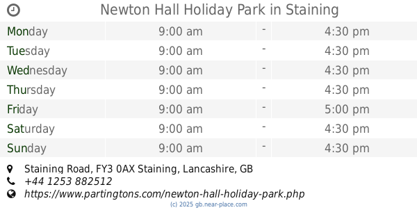
Newton Hall Holiday Park
Staining Road, Staining, Blackpool
Campground
read more
12.415 km
Newton Hall Holiday Park
Staining Road, Blackpool
Campground
read more
12.511 km
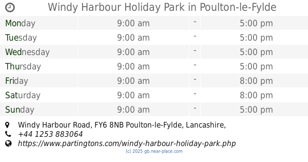
Windy Harbour Holiday Park
Windy Harbour Road, Poulton-le-Fylde
Campground
read more
15.316 km
Whittingham & Goosnargh Sports & Social Club
Old Hospital Grounds, Whittingham, Preston
Campground
read more
15.683 km
Century House Campsite
100 Turning Lane, Scarisbrick, Southport
Campground
read more
15.9 km
Queensland Country Park
Carr Lane, Hambleton
Campground
read more
15.947 km
Queensland Caravan Park
Carr Lane, Hambleton, Poulton-le-Fylde
Campground
read more
16.723 km
Kneps Farm Holiday Caravan Park
River Road, Stanah, Thornton-Cleveleys
Campground
read more
16.771 km
Flints Caravan Park
River Road, Thornton-Cleveleys
Campground
read more
16.773 km
North Country Leisure
River Road, Thornton-Cleveleys
Campground
read more
📑
all categories
Accounting
Administrative area level 1
Administrative area level 2
Airport
Amusement park
Aquarium
Art gallery
Atm
Bakery
Bank
Bar
Beauty salon
Bicycle store
Book store
Bowling alley
Bus station
Cafe
Campground
Car dealer
Car rental
Car repair
Car wash
Casino
Cemetery
Church
City hall
Clothing store
Colloquial area
Convenience store
Courthouse
Dentist
Department store
Doctor
Electrician
Electronics store
Embassy
Establishment
Finance
Fire station
Florist
Food
Funeral home
Furniture store
Gas station
General contractor
Grocery or supermarket
Gym
Hair care
Hardware store
Health
Hindu Temple
Home goods store
Hospital
Insurance agency
Jewelry store
Laundry
Lawyer
Library
Light rail station
Liquor store
Local government office
Locality
Locksmith
Lodging
Meal delivery
Meal takeaway
Mosque
Movie rental
Movie theater
Moving company
Museum
Natural feature
Neighborhood
Night club
Painter
Park
Parking
Pet store
Pharmacy
Physiotherapist
Place of worship
Plumber
Point of interest
Police
Political
Post office
Premise
Real estate agency
Restaurant
Roofing contractor
Route
Rv park, camping
School
Shoe store
Shopping mall
Spa
Stadium
Storage
Store
Subpremise
Subway station
Supermarket
Synagogue
Taxi stand
Train station
Transit station
Travel agency
University
Veterinary care
Zoo
administrative area level 3
administrative area level 4
sublocality level 1
↑