Church nearby Catholic Faith
United Kingdom
Church nearby Catholic Faith
Catholic Faith
39 Eccleston Square, London Det Forenede Kongerige
contacts phone
:
+44
Latitude:
51.4912054
, Longitude:
-0.1445579
read more
nearest Church
14 m
Catholic Gap Year
39 Eccleston Square, London
Church
read more
240 m
St Gabriel's Church
Warwick Square, London
Church
read more
388 m
Kharis Ministries
Park Plaza, 239 Vauxhall Bridge Road, London
Church
read more
497 m
Perform Within St Barnabas Church
Saint Barnabas Street, London
Church
read more
537 m
The Diocese of Westminster
46 Francis Street, London
Church
read more
560 m
St Michael's Church
Chester Square, London
Church
read more
579 m
Roman Catholic Archdiocese
Archbishops House, Ambrosden Avenue, London
Church
read more
622 m
Catedral De Westminster
42 Francis Street, London
Church
read more
622 m
Katedra Westminsterska
42 Francis Street, London
Church
read more
622 m
Westminster Cathedral
42 Francis Street, London
Church
read more
622 m
Westminster Katedral
42 Francis Street, London
Church
read more
649 m
Saint James the Less Church
4 Moreton Street, London
Church
read more
765 m
St Stephen's Church
38-42 Rochester Row, London
Church
read more
801 m
St Peter's
119 Eaton Square, London
Church
read more
825 m
Newlife Fellowship Victoria
55 Palace Street, London
Church
read more
871 m
Calvary Chapel Westminster
33 Wilfred Street, London
Church
read more
920 m
Holy Trinity Church
Sloane Street, London
Church
read more
922 m
The Girl Crusaders' Union (GCU)
31 Catherine Place, London
Church
read more
953 m
Sacred Heart Catholic Church
112 Horseferry Road, London
Church
read more
964 m
Westminster Chapel
Buckingham Gate, London
Church
read more
997 m
Westminster Baptist Church
100 Horseferry Road, London
Church
read more
1.017 km
Westminster Community Church
Grosvenor Hall, Vincent Street, London
Church
read more
1.113 km
United Reform Church
32-34 Great Peter Street, London
Church
read more
1.155 km
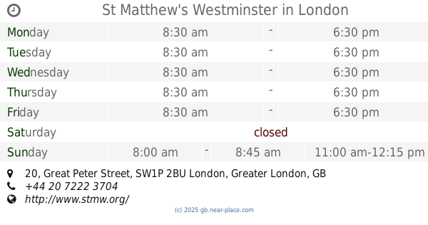
St Matthew's Westminster
20 Great Peter Street, London
Church
read more
1.186 km
CCC4vat2
1, Carysfort House, 14 West Halkin Street, London
Church
read more
📑
all categories
Accounting
Administrative area level 1
Administrative area level 2
Airport
Amusement park
Aquarium
Art gallery
Atm
Bakery
Bank
Bar
Beauty salon
Bicycle store
Book store
Bowling alley
Bus station
Cafe
Campground
Car dealer
Car rental
Car repair
Car wash
Casino
Cemetery
Church
City hall
Clothing store
Colloquial area
Convenience store
Courthouse
Dentist
Department store
Doctor
Electrician
Electronics store
Embassy
Establishment
Finance
Fire station
Florist
Food
Funeral home
Furniture store
Gas station
General contractor
Grocery or supermarket
Gym
Hair care
Hardware store
Health
Hindu Temple
Home goods store
Hospital
Insurance agency
Jewelry store
Laundry
Lawyer
Library
Light rail station
Liquor store
Local government office
Locality
Locksmith
Lodging
Meal delivery
Meal takeaway
Mosque
Movie rental
Movie theater
Moving company
Museum
Natural feature
Neighborhood
Night club
Painter
Park
Parking
Pet store
Pharmacy
Physiotherapist
Place of worship
Plumber
Point of interest
Police
Political
Post office
Premise
Real estate agency
Restaurant
Roofing contractor
Route
Rv park, camping
School
Shoe store
Shopping mall
Spa
Stadium
Storage
Store
Subpremise
Subway station
Supermarket
Synagogue
Taxi stand
Train station
Transit station
Travel agency
University
Veterinary care
Zoo
administrative area level 3
administrative area level 4
sublocality level 1
↑