Church nearby St. Johns Church, Waterloo
United Kingdom
Church nearby St. Johns Church, Waterloo
St. Johns Church, Waterloo
73 Waterloo Road, London United Kingdom
contacts phone
:
+44
Latitude:
51.504547
, Longitude:
-0.112088
read more
nearest Church
207 m
Grace London
Coin Street Neighbourhood Centre, 108 Stamford Street, London
Church
read more
431 m
St Andrew’s Church
Short Street, London
Church
read more
431 m
Saint Jude Church and Community Centre
Theatre View Apartments, 19 Short Street, London
Church
read more
509 m
South London Industrial Mission
27 Blackfriars Road, London
Church
read more
751 m
Archdiocese of Southwark
150 Saint George's Road, London
Church
read more
810 m
King's College Chapel
Kings College, Strand Lane, London
Church
read more
838 m
The Archbishop Amigo Jubilee Hall
Lambeth Road, London
Church
read more
839 m
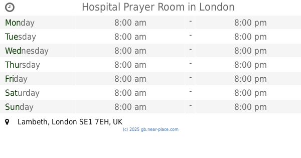
Hospital Prayer Room
London
Church
read more
898 m
St Martin-in-the-Fields
London
Church
read more
912 m
Saint Mary-le-Strand Church
Strand, London
Church
read more
949 m
Lambeth Methodist Mission
3-5 Lambeth Road, London
Church
read more
958 m
St Clement Danes
Central Church of the Royal Air Force, Strand, London
Church
read more
977 m
Iglesia del Temple
Temple, London
Church
read more
977 m
Temple Church
Temple, London
Church
read more
1.08 km
Christchurch London - Central Service
Puddle Dock, Blackfriars, London
Church
read more
1.112 km
Temple Church
Unnamed Road, London
Church
read more
1.114 km
Deeper Life Bible Church
83 Borough Road, London
Church
read more
1.119 km
St Paul's Church
Bedford Street, London
Church
read more
1.129 km
Crown Court Church of Scotland
Russell Street, London
Church
read more
1.151 km
Palaeolithic Insemination of a Royal Womb
Unnamed Road, London
Church
read more
1.157 km
Saint Georges Buldings
37 Saint George's Road, London
Church
read more
1.194 km
The Guild Church Of St. Benet
107 Queen Victoria Street, London
Church
read more
1.197 km
St Benets Metropolitian Welsh Church
93 Queen Victoria Street, London
Church
read more
1.229 km
Degustibus St Paul's
Carter Lane, London
Church
read more
1.259 km
The Salvation Army International Headquarters
101 Queen Victoria Street, London
Church
read more
📑
all categories
Accounting
Administrative area level 1
Administrative area level 2
Airport
Amusement park
Aquarium
Art gallery
Atm
Bakery
Bank
Bar
Beauty salon
Bicycle store
Book store
Bowling alley
Bus station
Cafe
Campground
Car dealer
Car rental
Car repair
Car wash
Casino
Cemetery
Church
City hall
Clothing store
Colloquial area
Convenience store
Courthouse
Dentist
Department store
Doctor
Electrician
Electronics store
Embassy
Establishment
Finance
Fire station
Florist
Food
Funeral home
Furniture store
Gas station
General contractor
Grocery or supermarket
Gym
Hair care
Hardware store
Health
Hindu Temple
Home goods store
Hospital
Insurance agency
Jewelry store
Laundry
Lawyer
Library
Light rail station
Liquor store
Local government office
Locality
Locksmith
Lodging
Meal delivery
Meal takeaway
Mosque
Movie rental
Movie theater
Moving company
Museum
Natural feature
Neighborhood
Night club
Painter
Park
Parking
Pet store
Pharmacy
Physiotherapist
Place of worship
Plumber
Point of interest
Police
Political
Post office
Premise
Real estate agency
Restaurant
Roofing contractor
Route
Rv park, camping
School
Shoe store
Shopping mall
Spa
Stadium
Storage
Store
Subpremise
Subway station
Supermarket
Synagogue
Taxi stand
Train station
Transit station
Travel agency
University
Veterinary care
Zoo
administrative area level 3
administrative area level 4
sublocality level 1
↑