Convenience store nearby Convin. Store
United Kingdom
Convenience store nearby Convin. Store
Convin. Store
55, Earlham Road, NR2 3AD, Norwich, Norfolk, GB United Kingdom
contacts phone
:
+44 1603 620711
Latitude:
52.6309094
, Longitude:
1.2785543
larger map & directions
read more
nearest Convenience store
At Your Convenience
55 Earlham Road, Norwich
Convenience store
read more
185 m
Premier Express
4 Alexandra Road, Norwich
Convenience store
read more
279 m
East of England Co-op Foodstore, Dereham Road, Norwich
58-62 Dereham Road, Norwich
Convenience store
read more
595 m
The Times
2 Vauxhall Street, Norwich
Convenience store
read more
658 m
Co-op Food
Earlham Road, Norwich
Convenience store
read more
664 m
The Co-Operative Food
Recreation Road, Norwich
Convenience store
read more
701 m
Alco Stores
28-29 Suffolk Square, Norwich
Convenience store
read more
703 m
Reds
35 Saint Benedicts Street, Norwich
Convenience store
read more
773 m
Lincoln Shopper
105 Portersfield Road, Norwich
Convenience store
read more
889 m
East of England Co-op Foodstore, Onley Street, Norwich
154 Unthank Road, Norwich
Convenience store
read more
893 m
Co-op Food
154 Unthank Road, Norwich
Convenience store
read more
1.077 km
M & M
65 Wingfield Road, Norwich
Convenience store
read more
1.152 km
Sainsbury's Local
9-13 Saint Stephens Street, Norwich
Convenience store
read more
1.236 km
SPAR
SPAR, Aylsham Road, St Augustines Gate, Norwich
Convenience store
read more
1.236 km
SPAR
Aylsham Road, Norwich
Convenience store
read more
1.272 km
McColl's
24 Anglia Square, Norwich
Convenience store
read more
1.28 km
Euro Foods
United Kingdom
Convenience store
read more
1.416 km
The Corner Stores
148 Colman Road, Norwich
Convenience store
read more
1.427 km
City Convenience Store
117 Magdalen Street, Norwich
Convenience store
read more
1.523 km
Magdalen Road Convenience Store
United Kingdom
Convenience store
read more
1.679 km
Angel Stores
58 Angel Road, Norwich
Convenience store
read more
1.84 km
Xpress Stores
219 Queens Road, Norwich
Convenience store
read more
1.853 km
Jk Convenience Store
United Kingdom
Convenience store
read more
1.985 km
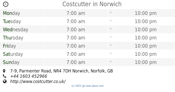
Costcutter
7-9 Parmenter Road, Norwich
Convenience store
read more
2.232 km
Co-op
195-197 Sprowston Road, Norwich
Convenience store
read more
📑
all categories
Accounting
Administrative area level 1
Administrative area level 2
Airport
Amusement park
Aquarium
Art gallery
Atm
Bakery
Bank
Bar
Beauty salon
Bicycle store
Book store
Bowling alley
Bus station
Cafe
Campground
Car dealer
Car rental
Car repair
Car wash
Casino
Cemetery
Church
City hall
Clothing store
Colloquial area
Convenience store
Courthouse
Dentist
Department store
Doctor
Electrician
Electronics store
Embassy
Establishment
Finance
Fire station
Florist
Food
Funeral home
Furniture store
Gas station
General contractor
Grocery or supermarket
Gym
Hair care
Hardware store
Health
Hindu Temple
Home goods store
Hospital
Insurance agency
Jewelry store
Laundry
Lawyer
Library
Light rail station
Liquor store
Local government office
Locality
Locksmith
Lodging
Meal delivery
Meal takeaway
Mosque
Movie rental
Movie theater
Moving company
Museum
Natural feature
Neighborhood
Night club
Painter
Park
Parking
Pet store
Pharmacy
Physiotherapist
Place of worship
Plumber
Point of interest
Police
Political
Post office
Premise
Real estate agency
Restaurant
Roofing contractor
Route
Rv park, camping
School
Shoe store
Shopping mall
Spa
Stadium
Storage
Store
Subpremise
Subway station
Supermarket
Synagogue
Taxi stand
Train station
Transit station
Travel agency
University
Veterinary care
Zoo
administrative area level 3
administrative area level 4
sublocality level 1
↑