Convenience store nearby Martin's
Coronavirus disease (COVID-19) Situation
confirmed cases
24910387
deaths
232112
United Kingdom
Convenience store nearby Martin's
Martin's
Wendene, NR5 9HA, Norwich, Norfolk, GB United Kingdom
contacts phone
:
+44 1603 734932
website:
www.mccolls.co.uk
Latitude:
52.6373409
, Longitude:
1.2169616
larger map & directions
read more
nearest Convenience store
729 m
Clover Hill News
20 Waldegrave, Norwich
Convenience store
read more
1.024 km
Co-operative Food
403 Dereham Rd, New Costessey, Norwich
Convenience store
read more
1.07 km
Stafford Stores & Post Office
1 Upper Stafford Avenue, Norwich
Convenience store
read more
1.075 km
Premier Express - Stafford Stores
3 Upper Stafford Avenue, Norwich
Convenience store
read more
1.496 km
One Stop
94 Norwich Road, Norwich
Convenience store
read more
1.54 km
Premier Stores
69 Knowland Grove, Norwich
Convenience store
read more
1.681 km
East Of England Co-operative Convenience Store
Norwich Road, New Costessey, Norwich, Norfolk
Convenience store
read more
1.721 km
McColl's
560A Dereham Road, Norwich
Convenience store
read more
1.729 km
Winam Food Store
Rockingham Road, Norwich
Convenience store
read more
1.736 km
Earlham Shopper
9-11 Earlham West Centre, Norwich
Convenience store
read more
2.103 km
Premier Convenience Store
85-87 Cadge Road, Norwich
Convenience store
read more
2.239 km
East Of England Co-operative Convenience Store
Earlham Green Lane, Norfolk
Convenience store
read more
2.563 km
North Earlham Stores
308 Bowthorpe Road, Norwich
Convenience store
read more
2.569 km
Little Melton Village Shop
66 School Lane, Little Melton, Norwich
Convenience store
read more
3.18 km
The Corner Stores
148 Colman Road, Norwich
Convenience store
read more
3.225 km
Colman News
141 Colman Road, Norwich
Convenience store
read more
3.293 km
SPAR
Shell (UK) Ltd Service Station, Sweet Briar Road, Norwich
Convenience store
read more
3.293 km
SPAR
Shell, Sweet Briar Road, Norwich
Convenience store
read more
3.572 km
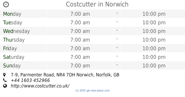
Costcutter
7-9 Parmenter Road, Norwich
Convenience store
read more
3.647 km
Co-op Food
Earlham Road, Norwich
Convenience store
read more
3.721 km
Woodlands Stores
196 Middletons Lane, Norwich
Convenience store
read more
4.034 km
Premier Express
4 Alexandra Road, Norwich
Convenience store
read more
4.361 km
Drayton Post Office
4 Fakenham Road, Drayton, Norwich
Convenience store
read more
4.362 km
East of England Co-op Foodstore, Dereham Road, Norwich
58-62 Dereham Road, Norwich
Convenience store
read more
5.484 km
Co-op
21 Friar Tuck Road, Norwich
Convenience store
read more
📑
all categories
Accounting
Administrative area level 1
Administrative area level 2
Airport
Amusement park
Aquarium
Art gallery
Atm
Bakery
Bank
Bar
Beauty salon
Bicycle store
Book store
Bowling alley
Bus station
Cafe
Campground
Car dealer
Car rental
Car repair
Car wash
Casino
Cemetery
Church
City hall
Clothing store
Colloquial area
Convenience store
Courthouse
Dentist
Department store
Doctor
Electrician
Electronics store
Embassy
Establishment
Finance
Fire station
Florist
Food
Funeral home
Furniture store
Gas station
General contractor
Grocery or supermarket
Gym
Hair care
Hardware store
Health
Hindu Temple
Home goods store
Hospital
Insurance agency
Jewelry store
Laundry
Lawyer
Library
Light rail station
Liquor store
Local government office
Locality
Locksmith
Lodging
Meal delivery
Meal takeaway
Mosque
Movie rental
Movie theater
Moving company
Museum
Natural feature
Neighborhood
Night club
Painter
Park
Parking
Pet store
Pharmacy
Physiotherapist
Place of worship
Plumber
Point of interest
Police
Political
Post office
Premise
Real estate agency
Restaurant
Roofing contractor
Route
Rv park, camping
School
Shoe store
Shopping mall
Spa
Stadium
Storage
Store
Subpremise
Subway station
Supermarket
Synagogue
Taxi stand
Train station
Transit station
Travel agency
University
Veterinary care
Zoo
administrative area level 3
administrative area level 4
sublocality level 1
↑