Convenience store nearby Sainsbury's Local
Coronavirus disease (COVID-19) Situation
confirmed cases
24910387
deaths
232112
United Kingdom
Convenience store nearby Sainsbury's Local
Sainsbury's Local
Asiatic Stores, Cowley Road, Oxford Det Forenede Kongerige
contacts phone
:
+44
Latitude:
51.7477984
, Longitude:
-1.2375487
read more
nearest Convenience store
Sainsbury's Local
134b Cowley Road, Oxford
Convenience store
read more
38 m
Sobieski
United Kingdom
Convenience store
read more
196 m
Baltic Food
88 Cowley Road, Oxford
Convenience store
read more
361 m
Zenobia
75 Saint Clement's Street, Oxford
Convenience store
read more
361 m
Zenobia
73 Saint Clement's Street, Oxford
Convenience store
read more
379 m
St Clements News & Booze
89 Saint Clement's Street, Oxford
Convenience store
read more
405 m
St Clements Stores
48 Saint Clement's Street, Oxford
Convenience store
read more
416 m
Hajis Superstore
256 Cowley Road, Oxford
Convenience store
read more
476 m
Co-op Food
217-219 Cowley Road, Oxford
Convenience store
read more
560 m
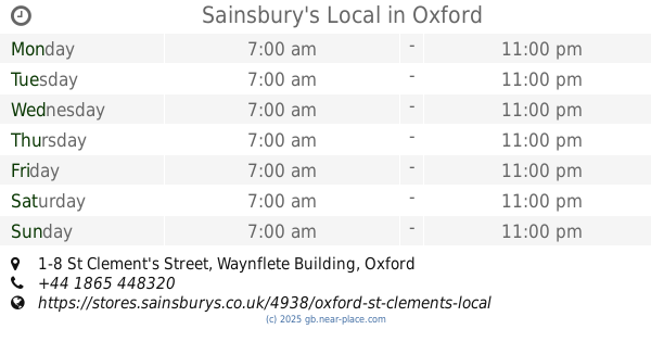
Sainsbury's Local
1-8 St Clement's Street, Waynflete Building, Oxford
Convenience store
read more
563 m
Sainsbury's Local
1-8, Waynflete Building, Saint Clement's Street, Oxford
Convenience store
read more
563 m
Sainsbury's Local
1-8, Waynflete, Saint Clement's Street, Oxford
Convenience store
read more
613 m
Macdillon Stores
36-37 Magdalen Road, Oxford
Convenience store
read more
615 m
Mak Food Store
United Kingdom
Convenience store
read more
997 m
The Midcounties Co-operative Food
297 Iffley Road, Oxford
Convenience store
read more
1.327 km
Bridge Stores
Meadow Lane, Oxford
Convenience store
read more
1.649 km
Sainsbury's Local
7 Magdalen Street, Oxford
Convenience store
read more
1.717 km
Londis
328 Abingdon Road, Oxford
Convenience store
read more
1.799 km
Spar
44-56 Oxford Road, Cowley, Oxford
Convenience store
read more
1.799 km
SPAR - MRH Cowley
44-56 Oxford Road, Cowley, Oxford
Convenience store
read more
1.819 km
Park Stores
16 Florence Park Road, Oxford
Convenience store
read more
1.893 km
Kumars at 39 Convenience store
39 Crescent Road, Oxford
Convenience store
read more
1.975 km
Iffley Community Shop
77a Church Way, Oxford
Convenience store
read more
2.341 km
Headington Food & Wine
121 London Road, Oxford
Convenience store
read more
2.391 km
East West Provisions
61A Woodstock Road, Oxford
Convenience store
read more
📑
all categories
Accounting
Administrative area level 1
Administrative area level 2
Airport
Amusement park
Aquarium
Art gallery
Atm
Bakery
Bank
Bar
Beauty salon
Bicycle store
Book store
Bowling alley
Bus station
Cafe
Campground
Car dealer
Car rental
Car repair
Car wash
Casino
Cemetery
Church
City hall
Clothing store
Colloquial area
Convenience store
Courthouse
Dentist
Department store
Doctor
Electrician
Electronics store
Embassy
Establishment
Finance
Fire station
Florist
Food
Funeral home
Furniture store
Gas station
General contractor
Grocery or supermarket
Gym
Hair care
Hardware store
Health
Hindu Temple
Home goods store
Hospital
Insurance agency
Jewelry store
Laundry
Lawyer
Library
Light rail station
Liquor store
Local government office
Locality
Locksmith
Lodging
Meal delivery
Meal takeaway
Mosque
Movie rental
Movie theater
Moving company
Museum
Natural feature
Neighborhood
Night club
Painter
Park
Parking
Pet store
Pharmacy
Physiotherapist
Place of worship
Plumber
Point of interest
Police
Political
Post office
Premise
Real estate agency
Restaurant
Roofing contractor
Route
Rv park, camping
School
Shoe store
Shopping mall
Spa
Stadium
Storage
Store
Subpremise
Subway station
Supermarket
Synagogue
Taxi stand
Train station
Transit station
Travel agency
University
Veterinary care
Zoo
administrative area level 3
administrative area level 4
sublocality level 1
↑