places in Derry
United Kingdom
Derry
Derry
Administrative Region:
Northern Ireland
population:
83 125
calling code:
+44-28
postcode:
BT47-BT48
Location on the map of United Kingdom
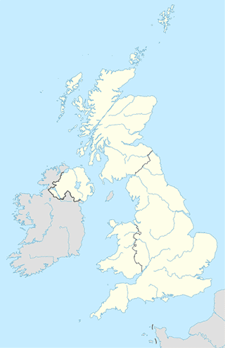
Derry
Neighborhood

Derry
Derry, Bonds Street, Londonderry
Neighborhood
read more
Lisnagelvin
United Kingdom
Neighborhood
read more
Lisnagelvin
Det Forenede Kongerige
Neighborhood
read more
Dungiven Road
United Kingdom
Neighborhood
read more
Dungiven Road
Det Forenede Kongerige
Neighborhood
read more
Shopping mall
Lisnagelvin
Lisnagelvin Road, Londonderry
Shopping mall
read more
Centra
24 Mountain View, Londonderry
Shopping mall
read more
jb3 mobile
Lisnagelvin Shopping Centre, Lisnagelvin Road, Londonderry
Shopping mall
read more
Trench Road Shopping Center
140 Hollymount Park, Londonderry
Shopping mall
read more
Foyleside Shopping Centre
19 Orchard Street, Londonderry
Shopping mall
read more
Rathmore Costcutter
5 Eastway, Londonderry
Shopping mall
read more
Northside Village Centre
Northside Village Centre, Glengalliagh Road, Londonderry
Shopping mall
read more
Quayside Shopping Centre & Car Park
42 Strand Road, Londonderry
Shopping mall
read more
Richmond Shopping Centre
Ferryquay Street, Londonderry
Shopping mall
read more
Rathmore Costcutter Hgv Entrance
5 Eastway, Londonderry
Shopping mall
read more
Ballyore Retail Park
Victoria Road, Newbuildings, Londonderry
Shopping mall
read more
Convenience store
SPAR Strathfoyle
1, Strathfoyle Village Centre, Temple Road, Londonderry
Convenience store
read more
Centra
14 Trench Road, Londonderry
Convenience store
read more
SPAR Glenshane Road
66 Glenshane Road, Londonderry
Convenience store
read more
N I S A
73 Glenshane Road, Londonderry
Convenience store
read more
Kellys
2 Ferndale Road, Londonderry
Convenience store
read more
Day to Day
Sevenoaks, Londonderry
Convenience store
read more
SPAR Church Meadows
16 Rossdowney Road, Londonderry
Convenience store
read more
M McCloskey
92 Strabane Old Road, Londonderry
Convenience store
read more
SPAR Church Brae
60 Church Brae, Londonderry
Convenience store
read more
Craig's Costcutter
5FX, 20 Crescent Link, Londonderry
Convenience store
read more
Harkins Newsagents
178 Lecky Road, Derry
Convenience store
read more
EUROSPAR Creggan Road
155 Creggan Road, Derry
Convenience store
read more
The Bus Stop Stores
25 Foyle Street, Londonderry
Convenience store
read more
Devine J G
105 Marlborough Road, Londonderry
Convenience store
read more
WHITES NEWS AND VIEWS
16 Blucher Street, Londonderry
Convenience store
read more
Funeral home
David & Ruth Hay & Sons Dip F.D.
24a Church Road, Londonderry
Funeral home
read more
Adair & Neely
92 Duke Street, Londonderry
Funeral home
read more
Harley Funeral Directors
67 Creggan Road, Londonderry
Funeral home
read more
Mc Clafferty Funeral Directors
Rathmore Business Park, Blighs Lane, Londonderry
Funeral home
read more
Gas station
Esso A2
Londonderry
Gas station
read more
Waterside Service Station
29 Glendermott Road, Londonderry
Gas station
read more
Magee Fuels
United Kingdom
Gas station
read more
Kelly Fuels
5 Bay Rd, Londonderry
Gas station
read more
Texaco E16@A6
Londonderry
Gas station
read more
desmonds ford garage
Strand Road, Londonderry
Gas station
read more
Link Service Station
180 Creggan Road, Londonderry
Gas station
read more
Hutcheon Fuels
74 Blighs Ln, Londonderry
Gas station
read more
Tesco Petrol Station
63 Blackburn Crescent, Londonderry
Gas station
read more
Texaco B527
Londonderry
Gas station
read more
Mc Ginleys GO 24hr Fuel Station
20 Buncrana Road, Londonderry
Gas station
read more
Coyle Fuels
Duncreggan Road, Londonderry
Gas station
read more
Mc Ginleys Spar & Deli
20 Buncrana Road, Londonderry
Gas station
read more
Maxol Service Station, Glendermott Road
29a Glendermott Road, Londonderry
Gas station
read more
Faughan Valley Service Station
66 Glenshane Road, Londonderry
Gas station
read more
📑
Derry all categories
Accounting
Administrative area level 2
Aquarium
Art gallery
Atm
Bakery
Bank
Bar
Beauty salon
Bicycle store
Book store
Bus station
Cafe
Campground
Car dealer
Car rental
Car repair
Car wash
Cemetery
Church
City hall
Clothing store
Colloquial area
Convenience store
Courthouse
Dentist
Department store
Doctor
Electrician
Electronics store
Finance
Fire station
Florist
Food
Funeral home
Furniture store
Gas station
General contractor
Grocery or supermarket
Gym
Hair care
Hardware store
Health
Home goods store
Hospital
Insurance agency
Jewelry store
Laundry
Lawyer
Library
Liquor store
Local government office
Locality
Locksmith
Lodging
Meal delivery
Meal takeaway
Mosque
Movie theater
Moving company
Museum
Natural feature
Neighborhood
Night club
Painter
Park
Parking
Pet store
Pharmacy
Physiotherapist
Place of worship
Plumber
Point of interest
Police
Post office
Premise
Real estate agency
Restaurant
Roofing contractor
Route
School
Shoe store
Shopping mall
Spa
Stadium
Storage
Store
Subpremise
Supermarket
Train station
Transit station
Travel agency
University
Veterinary care
sublocality level 1
↑