Gas station nearby Applegreen Service Station
United Kingdom
Gas station nearby Applegreen Service Station
Applegreen Service Station
Swaythling Road, West End, Southampton Reino Unido
contacts phone
:
+44
Latitude:
50.9338339
, Longitude:
-1.3483736
read more
nearest Gas station
1.418 km
Esso
149 West End Road, Southampton
Gas station
read more
2.214 km
Len Harfield Ltd
6 Cobden Avenue, Southampton
Gas station
read more
2.232 km
Shell
Thomas Lewis Way, Southampton
Gas station
read more
2.289 km
Texaco
Thornhill Park Road, Southampton
Gas station
read more
2.304 km
Co op food
15A Thornhill Park Road, Southampton
Gas station
read more
2.752 km
BP
123 Bitterne Road West, Southampton
Gas station
read more
2.969 km
Sainsbury's Petrol Station
Tollbar Way, Hedge End, Southampton
Gas station
read more
3.179 km
Texaco Eastleigh Service Station
109 Southampton Road, Eastleigh
Gas station
read more
3.449 km
Soltron I W Ltd
7, Bldg Shamrock Quay, William Street, Southampton
Gas station
read more
3.507 km
BP
M27, Southampton
Gas station
read more
3.569 km
Shell Select
197 Burgess Road, Southampton
Gas station
read more
3.578 km
Shell
197 Burgess Road, Southampton
Gas station
read more
3.704 km
Esso
Lodge Road, Southampton
Gas station
read more
3.793 km
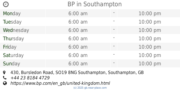
BP
430 Bursledon Road, Southampton
Gas station
read more
3.916 km
Esso
110 Northam Road, Southampton
Gas station
read more
3.916 km
M R H Service Station
110 Northam Road, Southampton
Gas station
read more
3.988 km
Shell
Passfield Avenue, Eastleigh
Gas station
read more
3.989 km
Shell
Passfield Avenue, Eastleigh, Southamton
Gas station
read more
4.037 km
Esso
Bishopstoke Road, Eastleigh
Gas station
read more
4.23 km
Texaco
Horton Heath Service Station, Botley Road, Horton Heath, Eastleigh
Gas station
read more
4.444 km
Shell
Chilworth Roundabout, Southampton
Gas station
read more
4.498 km
Texaco Service Station
Botley, Southampton
Gas station
read more
4.86 km
Asda Petrol Station
Bournemouth Road, Chandler's Ford, Eastleigh
Gas station
read more
4.895 km
Tesco
Southampton
Gas station
read more
4.97 km
Esso
Winchester Road, Fair Oak, Eastleigh
Gas station
read more
📑
all categories
Accounting
Administrative area level 1
Administrative area level 2
Airport
Amusement park
Aquarium
Art gallery
Atm
Bakery
Bank
Bar
Beauty salon
Bicycle store
Book store
Bowling alley
Bus station
Cafe
Campground
Car dealer
Car rental
Car repair
Car wash
Casino
Cemetery
Church
City hall
Clothing store
Colloquial area
Convenience store
Courthouse
Dentist
Department store
Doctor
Electrician
Electronics store
Embassy
Establishment
Finance
Fire station
Florist
Food
Funeral home
Furniture store
Gas station
General contractor
Grocery or supermarket
Gym
Hair care
Hardware store
Health
Hindu Temple
Home goods store
Hospital
Insurance agency
Jewelry store
Laundry
Lawyer
Library
Light rail station
Liquor store
Local government office
Locality
Locksmith
Lodging
Meal delivery
Meal takeaway
Mosque
Movie rental
Movie theater
Moving company
Museum
Natural feature
Neighborhood
Night club
Painter
Park
Parking
Pet store
Pharmacy
Physiotherapist
Place of worship
Plumber
Point of interest
Police
Political
Post office
Premise
Real estate agency
Restaurant
Roofing contractor
Route
Rv park, camping
School
Shoe store
Shopping mall
Spa
Stadium
Storage
Store
Subpremise
Subway station
Supermarket
Synagogue
Taxi stand
Train station
Transit station
Travel agency
University
Veterinary care
Zoo
administrative area level 3
administrative area level 4
sublocality level 1
↑