Gas station nearby BP
United Kingdom
Gas station nearby BP
BP
Railway Road, Skelmersdale Vereinigtes Königreich
contacts phone
:
+44
Latitude:
53.5504993
, Longitude:
-2.8092113
read more
nearest Gas station
7.949 km
Gulf
Bank Lane, Liverpool
Gas station
read more
7.96 km
Gulf Mount Garage
The Mount, Liverpool
Gas station
read more
9.476 km
BP
Scot Lane, Wigan
Gas station
read more
10.398 km
BP
240 Warrington Road, Wigan
Gas station
read more
10.539 km
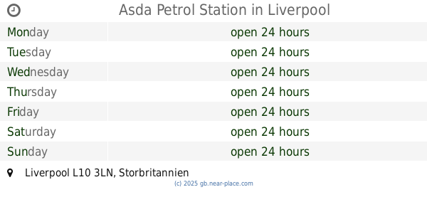
Asda Petrol Station
Robin Park, 0XA,, Soho Street, Wigan
Gas station
read more
10.82 km
Sainsbury's Petrol Station
Worthington Way, Wigan
Gas station
read more
11.04 km
Shell
878 Warrington Road, Wigan
Gas station
read more
11.206 km
Texaco
Garswood Road, Ashton-in-Makerfield, Wigan
Gas station
read more
11.211 km
Garswood Service Station
280, 290 Garswood Road, Wigan
Gas station
read more
11.419 km
Asda Petrol Station
Liverpool
Gas station
read more
11.419 km
W M Morrisons Petrol Station
Boundary Road, Saint Helens
Gas station
read more
11.46 km
Asda Petrol
10 Palmer Close, Saint Helens
Gas station
read more
12.769 km
Tesco Petrol Station
201 Saint Helens Linkway, Saint Helens
Gas station
read more
12.828 km
Gulf Dunnings Bridge Filling Station
Dunnings Bridge Road, Bootle
Gas station
read more
12.848 km
Costco Filling Station (Members Only)
Andover Road, Haydock, Saint Helens
Gas station
read more
12.954 km
Asda Haydock East Lancashire Road Petrol Filling Station
A580, East Lancashire Road, Haydock
Gas station
read more
13.971 km
Tesco 24hr Fuel
48 Speakman Way, Prescot
Gas station
read more
14.603 km
Almonds Green Service Station
111 Almond's Green, Liverpool
Gas station
read more
14.74 km
Shell
Liverpool Road, Liverpool
Gas station
read more
16.409 km
Esso
CROSBY, College Road, Brighton le Sands, Liverpool
Gas station
read more
16.728 km
AS24
Crosby Road South, Liverpool
Gas station
read more
16.762 km
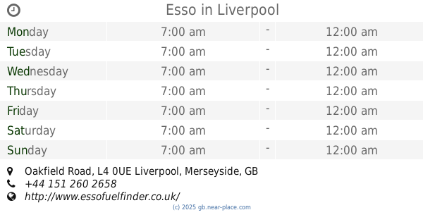
Esso
Oakfield Road, Liverpool
Gas station
read more
17.092 km
Shell Derby Road
100 Derby Road, Liverpool
Gas station
read more
17.103 km
Shell Select
100 Derby Road, Bootle
Gas station
read more
18.676 km
County Oil
157 Regent Rd, Liverpool
Gas station
read more
📑
all categories
Accounting
Administrative area level 1
Administrative area level 2
Airport
Amusement park
Aquarium
Art gallery
Atm
Bakery
Bank
Bar
Beauty salon
Bicycle store
Book store
Bowling alley
Bus station
Cafe
Campground
Car dealer
Car rental
Car repair
Car wash
Casino
Cemetery
Church
City hall
Clothing store
Colloquial area
Convenience store
Courthouse
Dentist
Department store
Doctor
Electrician
Electronics store
Embassy
Establishment
Finance
Fire station
Florist
Food
Funeral home
Furniture store
Gas station
General contractor
Grocery or supermarket
Gym
Hair care
Hardware store
Health
Hindu Temple
Home goods store
Hospital
Insurance agency
Jewelry store
Laundry
Lawyer
Library
Light rail station
Liquor store
Local government office
Locality
Locksmith
Lodging
Meal delivery
Meal takeaway
Mosque
Movie rental
Movie theater
Moving company
Museum
Natural feature
Neighborhood
Night club
Painter
Park
Parking
Pet store
Pharmacy
Physiotherapist
Place of worship
Plumber
Point of interest
Police
Political
Post office
Premise
Real estate agency
Restaurant
Roofing contractor
Route
Rv park, camping
School
Shoe store
Shopping mall
Spa
Stadium
Storage
Store
Subpremise
Subway station
Supermarket
Synagogue
Taxi stand
Train station
Transit station
Travel agency
University
Veterinary care
Zoo
administrative area level 3
administrative area level 4
sublocality level 1
↑