Gas station nearby Esso
United Kingdom
Gas station nearby Esso
Esso
180 South Coast Road, Peacehaven Reino Unido
contacts phone
:
+44
Latitude:
50.7910349
, Longitude:
0.0007395
read more
nearest Gas station
165 m
BP
South Coast Road, Peacehaven
Gas station
read more
893 m
Star Fuels Ltd
79 South Coast Road, Peacehaven
Gas station
read more
1.227 km
Watson Heath LTD Service station
376 South Coast Road, Telscombe Cliffs, Peacehaven
Gas station
read more
1.249 km
Texaco
376 South Coast Road, Telscombe Cliffs, Peacehaven
Gas station
read more
4.092 km
Texaco UK
Avis Way, Newhaven
Gas station
read more
4.311 km
Sainsbury's Petrol Station
The Drove, Newhaven
Gas station
read more
7.309 km
Woodingdean Service Station
534-540 Falmer Road, Brighton
Gas station
read more
7.317 km
Texaco
Falmer Road, Brighton
Gas station
read more
7.69 km
Asda Petrol Station
Brighton Marina, Brighton
Gas station
read more
8.468 km
Esso
236 Eastern Road, Brighton
Gas station
read more
9.7 km
Marks & Spencer Malling BP
BP, 96-106 Malling Street, Lewes
Gas station
read more
10.209 km
Vogue Gyratory
96 Lewes Road, Brighton
Gas station
read more
10.722 km
BP
Ditchling Road, Brighton
Gas station
read more
11.125 km
Selmeston Service Station
Lewes Road, Polegate
Gas station
read more
11.503 km
I E S
185 Dyke Road, Hove
Gas station
read more
12.127 km
Esso
239 Dyke Road, Hove
Gas station
read more
12.147 km
Audi, Gas Stion
241 Dyke Road, Hove, Brighton
Gas station
read more
12.343 km
ASDA Petrol Station
Crowhurst Road, Brighton
Gas station
read more
12.932 km
Esso
Station Approach, Denmark Villas, Brighton
Gas station
read more
13.39 km
Esso
Patcham Bypass, Brighton
Gas station
read more
13.473 km
Shell
132-134 Old Shoreham Road, Hove
Gas station
read more
13.972 km
MRH Brighton
Mill Road, Sussex
Gas station
read more
13.973 km
BP
Mill Road, Brighton
Gas station
read more
14.819 km
Esso
United Kingdom
Gas station
read more
15.496 km
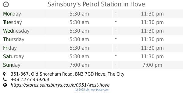
Sainsbury's Petrol Station
361-367 Old Shoreham Road, Hove
Gas station
read more
📑
all categories
Accounting
Administrative area level 1
Administrative area level 2
Airport
Amusement park
Aquarium
Art gallery
Atm
Bakery
Bank
Bar
Beauty salon
Bicycle store
Book store
Bowling alley
Bus station
Cafe
Campground
Car dealer
Car rental
Car repair
Car wash
Casino
Cemetery
Church
City hall
Clothing store
Colloquial area
Convenience store
Courthouse
Dentist
Department store
Doctor
Electrician
Electronics store
Embassy
Establishment
Finance
Fire station
Florist
Food
Funeral home
Furniture store
Gas station
General contractor
Grocery or supermarket
Gym
Hair care
Hardware store
Health
Hindu Temple
Home goods store
Hospital
Insurance agency
Jewelry store
Laundry
Lawyer
Library
Light rail station
Liquor store
Local government office
Locality
Locksmith
Lodging
Meal delivery
Meal takeaway
Mosque
Movie rental
Movie theater
Moving company
Museum
Natural feature
Neighborhood
Night club
Painter
Park
Parking
Pet store
Pharmacy
Physiotherapist
Place of worship
Plumber
Point of interest
Police
Political
Post office
Premise
Real estate agency
Restaurant
Roofing contractor
Route
Rv park, camping
School
Shoe store
Shopping mall
Spa
Stadium
Storage
Store
Subpremise
Subway station
Supermarket
Synagogue
Taxi stand
Train station
Transit station
Travel agency
University
Veterinary care
Zoo
administrative area level 3
administrative area level 4
sublocality level 1
↑