Gas station nearby Esso
United Kingdom
Gas station nearby Esso
Esso
Bagshot Road, Brookwood, Woking United Kingdom
contacts phone
:
+44
Latitude:
51.3061164
, Longitude:
-0.6266443
read more
nearest Gas station
682 m
Sainsbury's Petrol Station
Redding Way, Knaphill, Woking
Gas station
read more
686 m
Sainsbury's Petrol Station
Redding Way, Woking
Gas station
read more
1.503 km
Esso Shop & Drive
23 High Street, Knaphill, Woking
Gas station
read more
1.514 km
Esso
23 High Street, Knaphill, Woking
Gas station
read more
2.431 km
Stucas Gas Services Ltd
27 Rosebury Drive, Bisley, Woking
Gas station
read more
2.76 km
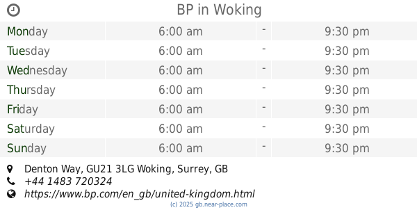
BP
Denton Way, Woking
Gas station
read more
3.677 km
Marks & Spencer Gordon BP
Guildford Road, Woking
Gas station
read more
3.683 km
BP
Guildford Road, Woking
Gas station
read more
4.161 km
Horsell Service Station
100 High Street, Woking
Gas station
read more
4.313 km
Morrisons Petrol Station
82 Goldsworth Road, Woking
Gas station
read more
4.663 km
Esso
Rowell End Villas, Station Road, Chobham, Woking
Gas station
read more
5.033 km
Woking Station
High Street, Woking
Gas station
read more
5.215 km
Retail Petroleum Services Ltd
Elizabeth House, The Broadway, Woking
Gas station
read more
7.028 km
ATM (Frimley Green Filling Station)
259 Frimley Green Road, Frimley Green
Gas station
read more
7.739 km
BP
London Road, Guildford
Gas station
read more
7.913 km
B P Service Station
A3, Ripley By-Pass, Woking
Gas station
read more
11.091 km
Jet Petrol Station
Oyster Lane, West Byfleet
Gas station
read more
11.739 km
Shell
London Road, Virginia Water
Gas station
read more
12.503 km
Shell
102 Yorktown Road, Bracknell, Sandhurst
Gas station
read more
14.243 km
Shell
181 Oatlands Drive, Weybridge
Gas station
read more
15.815 km
BP
26-34 High Street, Shepperton
Gas station
read more
15.828 km
Marks & Spencer Shepperton BP
B376 High Street, Shepperton
Gas station
read more
17.953 km
Esso
404 STAINES ROAD, WEST, Ashford
Gas station
read more
18.066 km
Texaco
404 Staines Road West, Ashford
Gas station
read more
18.297 km
BP
70 Finchampstead Road, Wokingham
Gas station
read more
📑
all categories
Accounting
Administrative area level 1
Administrative area level 2
Airport
Amusement park
Aquarium
Art gallery
Atm
Bakery
Bank
Bar
Beauty salon
Bicycle store
Book store
Bowling alley
Bus station
Cafe
Campground
Car dealer
Car rental
Car repair
Car wash
Casino
Cemetery
Church
City hall
Clothing store
Colloquial area
Convenience store
Courthouse
Dentist
Department store
Doctor
Electrician
Electronics store
Embassy
Establishment
Finance
Fire station
Florist
Food
Funeral home
Furniture store
Gas station
General contractor
Grocery or supermarket
Gym
Hair care
Hardware store
Health
Hindu Temple
Home goods store
Hospital
Insurance agency
Jewelry store
Laundry
Lawyer
Library
Light rail station
Liquor store
Local government office
Locality
Locksmith
Lodging
Meal delivery
Meal takeaway
Mosque
Movie rental
Movie theater
Moving company
Museum
Natural feature
Neighborhood
Night club
Painter
Park
Parking
Pet store
Pharmacy
Physiotherapist
Place of worship
Plumber
Point of interest
Police
Political
Post office
Premise
Real estate agency
Restaurant
Roofing contractor
Route
Rv park, camping
School
Shoe store
Shopping mall
Spa
Stadium
Storage
Store
Subpremise
Subway station
Supermarket
Synagogue
Taxi stand
Train station
Transit station
Travel agency
University
Veterinary care
Zoo
administrative area level 3
administrative area level 4
sublocality level 1
↑