Gas station nearby Tesco Petrol
United Kingdom
Gas station nearby Tesco Petrol
Tesco Petrol
2 Drury Way, London United Kingdom
contacts phone
:
+44
Latitude:
51.554498
, Longitude:
-0.2586934
read more
nearest Gas station
Tesco
2 Drury Way, London
Gas station
read more
218 m
Tesco Phone Shop
Great Central Way, Neasden, London
Gas station
read more
218 m
Tesco Phone Shop
Wembley Extra, Great Central Way, London
Gas station
read more
498 m
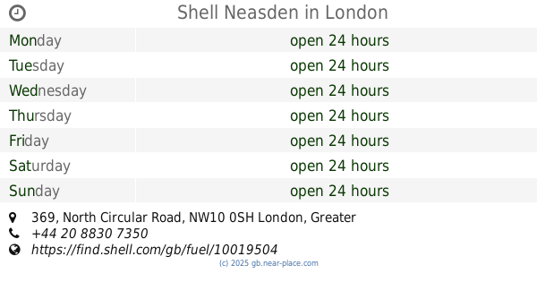
Shell Neasden
369 North Circular Road, London
Gas station
read more
507 m
Shell Select
369 North Circular Road, London
Gas station
read more
716 m
Texaco
91 Neasden Lane, London
Gas station
read more
823 m
Brentfield Service Station
Brentfield Road, London
Gas station
read more
1.019 km
Esso
Dudden Hill Lane, Willesden
Gas station
read more
1.036 km
E G Service Station
Dudden Hill Lane, London
Gas station
read more
1.227 km
BP
2 Blackbird Hill, Wembley
Gas station
read more
1.227 km
BP BLACKBIRD HILL
2 Blackbird Hill, Wembley
Gas station
read more
1.234 km
Marks & Spencer Blackbird BP
Brent Cross, BP, Brent Cross
Gas station
read more
1.393 km
Harvest
United Kingdom
Gas station
read more
1.395 km
Jet Craven Park Service Station
2 Church Road, London
Gas station
read more
1.582 km
Asda Filling Station
Forty Lane, Wembley
Gas station
read more
1.628 km
Station Express
Agenta Kiosk, Argenta Way, London
Gas station
read more
1.809 km
Shell
Empire Way, Wembley
Gas station
read more
2.21 km
Esso
Abbey Road, London
Gas station
read more
2.588 km
HKS Staples Corner
383 Edgware Road, London
Gas station
read more
2.591 km
BP
387 Edgware Road, London
Gas station
read more
2.597 km
Ccs car wash brent
Abbey Road, London
Gas station
read more
2.601 km
Shell
383 Edgware Road, London
Gas station
read more
2.646 km
Shell Select
290 Willesden Lane, London
Gas station
read more
2.694 km
M R H Service Station
374 Edgware Road, London
Gas station
read more
3.05 km
BP
281 West Hendon Broadway, Edgware, London
Gas station
read more
📑
all categories
Accounting
Administrative area level 1
Administrative area level 2
Airport
Amusement park
Aquarium
Art gallery
Atm
Bakery
Bank
Bar
Beauty salon
Bicycle store
Book store
Bowling alley
Bus station
Cafe
Campground
Car dealer
Car rental
Car repair
Car wash
Casino
Cemetery
Church
City hall
Clothing store
Colloquial area
Convenience store
Courthouse
Dentist
Department store
Doctor
Electrician
Electronics store
Embassy
Establishment
Finance
Fire station
Florist
Food
Funeral home
Furniture store
Gas station
General contractor
Grocery or supermarket
Gym
Hair care
Hardware store
Health
Hindu Temple
Home goods store
Hospital
Insurance agency
Jewelry store
Laundry
Lawyer
Library
Light rail station
Liquor store
Local government office
Locality
Locksmith
Lodging
Meal delivery
Meal takeaway
Mosque
Movie rental
Movie theater
Moving company
Museum
Natural feature
Neighborhood
Night club
Painter
Park
Parking
Pet store
Pharmacy
Physiotherapist
Place of worship
Plumber
Point of interest
Police
Political
Post office
Premise
Real estate agency
Restaurant
Roofing contractor
Route
Rv park, camping
School
Shoe store
Shopping mall
Spa
Stadium
Storage
Store
Subpremise
Subway station
Supermarket
Synagogue
Taxi stand
Train station
Transit station
Travel agency
University
Veterinary care
Zoo
administrative area level 3
administrative area level 4
sublocality level 1
↑