Gas station nearby Texaco Service Station
United Kingdom
Gas station nearby Texaco Service Station
Texaco Service Station
705 Woodborough Road, Nottingham United Kingdom
contacts phone
:
+44
Latitude:
52.983115
, Longitude:
-1.1237673
read more
nearest Gas station
1.623 km
BP
Mansfield Road, Nottingham
Gas station
read more
1.984 km
Sainsbury's Petrol Station
Sir John Robinson Way, Arnold, Nottingham
Gas station
read more
2 km
Car Wash Sainsbury Petrol Station
Daybrook, Nottingham
Gas station
read more
2.119 km
Hand Car Wash
691 Carlton Road, Nottingham
Gas station
read more
2.38 km
Texaco
Hucknall Road, Nottingham
Gas station
read more
2.479 km
Shell
Carlton Road, Nottingham
Gas station
read more
2.523 km
ASDA PETROL STATION CARD ONLY
Arnold, Nottingham
Gas station
read more
2.673 km
Shell
Sherwood Rise, Nottingham
Gas station
read more
2.692 km
Esso
Westdale Lane East, Carlton
Gas station
read more
2.719 km
East Lane Petrol Station
Westdale Lane East, Carlton, Nottingham
Gas station
read more
2.997 km
Shell
Carlton Road, Carlton, Nottingham
Gas station
read more
3.473 km
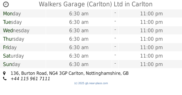
Walkers Garage (Carlton) Ltd
136 Burton Road, Carlton, Nottingham
Gas station
read more
3.491 km
Texaco
136 Burton Road, Nottingham
Gas station
read more
3.648 km
Asda Petrol Station
228-240 Radford Road, Nottingham
Gas station
read more
4.077 km
BP
Daleside Road, Nottingham
Gas station
read more
4.23 km
Tesco Petrol Station
3 Celandine Close, Nottingham
Gas station
read more
4.303 km
Jet Petrol Station
Meadow Lane, Nottingham
Gas station
read more
4.398 km
Esso
Nuthall Road, Nottingham
Gas station
read more
4.551 km
MRH St Marys
Nuthall Road
Gas station
read more
4.644 km
ATM (Murco - Sportsman Filling Station)
Meadow Lane, Nottingham
Gas station
read more
4.731 km
BP
199-203 Lenton Boulevard, Nottingham
Gas station
read more
4.731 km
BP
199-203 Lenton Boulevard, A6130
Gas station
read more
4.975 km
Tesco Petrol Station
629 Nuthall Road, Nottingham
Gas station
read more
5.013 km
Sainsbury's Petrol Station
11 Castle Bridge Road, Nottingham
Gas station
read more
5.393 km
Morrisons Petrol Station
Leen Drive, Nottingham
Gas station
read more
📑
all categories
Accounting
Administrative area level 1
Administrative area level 2
Airport
Amusement park
Aquarium
Art gallery
Atm
Bakery
Bank
Bar
Beauty salon
Bicycle store
Book store
Bowling alley
Bus station
Cafe
Campground
Car dealer
Car rental
Car repair
Car wash
Casino
Cemetery
Church
City hall
Clothing store
Colloquial area
Convenience store
Courthouse
Dentist
Department store
Doctor
Electrician
Electronics store
Embassy
Establishment
Finance
Fire station
Florist
Food
Funeral home
Furniture store
Gas station
General contractor
Grocery or supermarket
Gym
Hair care
Hardware store
Health
Hindu Temple
Home goods store
Hospital
Insurance agency
Jewelry store
Laundry
Lawyer
Library
Light rail station
Liquor store
Local government office
Locality
Locksmith
Lodging
Meal delivery
Meal takeaway
Mosque
Movie rental
Movie theater
Moving company
Museum
Natural feature
Neighborhood
Night club
Painter
Park
Parking
Pet store
Pharmacy
Physiotherapist
Place of worship
Plumber
Point of interest
Police
Political
Post office
Premise
Real estate agency
Restaurant
Roofing contractor
Route
Rv park, camping
School
Shoe store
Shopping mall
Spa
Stadium
Storage
Store
Subpremise
Subway station
Supermarket
Synagogue
Taxi stand
Train station
Transit station
Travel agency
University
Veterinary care
Zoo
administrative area level 3
administrative area level 4
sublocality level 1
↑