Local government office nearby Birmingham City Council - Selly Oak District
United Kingdom
Local government office nearby Birmingham City Council - Selly Oak District
Birmingham City Council - Selly Oak District
2-4 Bournville Lane, Birmingham Reino Unido
contacts phone
:
+44
Latitude:
52.4290772
, Longitude:
-1.9229484
read more
nearest Local government office
2.512 km
west midlands police and partnerships HUB
Birmingham
Local government office
read more
4.52 km
Acas Counselling Service
1112 Highfield Road, Birmingham
Local government office
read more
4.585 km
M&N HEALTHCARE
22, QUADRANT COURT, 48 Calthorpe Road, Birmingham
Local government office
read more
4.587 km
Andy Street
8 Greenfield Crescent, Birmingham
Local government office
read more
4.668 km
Patronato Acli
2 Calthorpe Rd, Birmingham
Local government office
read more
4.721 km
Executive Network Legal Ltd
7 George Road, Birmingham
Local government office
read more
4.782 km
Connaught Partners Ltd
123 Hagley Road, Birmingham
Local government office
read more
4.817 km
Heantun Housing Association
93 Hagley Road, Birmingham
Local government office
read more
4.823 km
NHS Birmingham and Solihull CCG
142 Hagley Road, Birmingham
Local government office
read more
5.083 km
Highways England
B15 1AY Broad Street, Birmingham
Local government office
read more
5.237 km
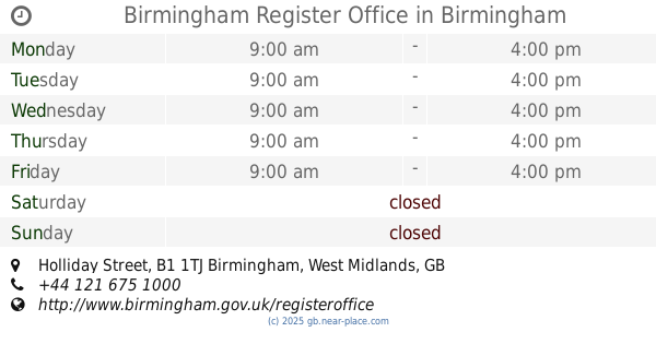
Birmingham Register Office
Holliday Street, Birmingham
Local government office
read more
5.541 km
Hsbc Headquarters
5 Bridge Street, Birmingham
Local government office
read more
5.801 km
Waterloo House
20 Waterloo Street, Birmingham
Local government office
read more
5.923 km
Care Leavers Service
28 Acorn Grove, Birmingham
Local government office
read more
6.339 km
Nakib Express UK
543A Coventry Road, Birmingham
Local government office
read more
6.341 km
Probation Service Victim Liaison Office
52 Newton Street, Birmingham
Local government office
read more
6.757 km
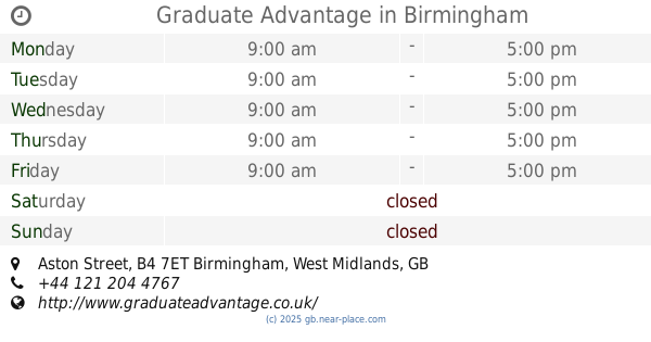
Graduate Advantage
Aston Street, Birmingham
Local government office
read more
7.42 km
Acas Counselling Service
235 Bridge Street West, Birmingham
Local government office
read more
8.787 km
Keystone Housing & Support
7 Sycamore Road, Birmingham
Local government office
read more
11.636 km
Doocey Traffic Management
10/11, Waterside Industrial Estate, Doulton Road, Cradley Heath, Rowley Regis
Local government office
read more
11.908 km
Dudley SENDIASS (Formerly Dudley Parent Partnership Service)
Saltwells Education Centre, Bowling Green Road, Dudley
Local government office
read more
14.546 km
Dudley Council Housing Services
Harbour Buildings Waterfront West, Dudley Road, Brierley Hill
Local government office
read more
14.663 km
Social Services
Bosworth Centre Auckland Drive, Birmingham
Local government office
read more
14.976 km
Working Tax Credit
1 Railway Terrace, Wednesbury
Local government office
read more
15.057 km
Sandwell Local, Wednesbury
Town Hall,, Lower High Street, Wednesbury
Local government office
read more
📑
all categories
Accounting
Administrative area level 1
Administrative area level 2
Airport
Amusement park
Aquarium
Art gallery
Atm
Bakery
Bank
Bar
Beauty salon
Bicycle store
Book store
Bowling alley
Bus station
Cafe
Campground
Car dealer
Car rental
Car repair
Car wash
Casino
Cemetery
Church
City hall
Clothing store
Colloquial area
Convenience store
Courthouse
Dentist
Department store
Doctor
Electrician
Electronics store
Embassy
Establishment
Finance
Fire station
Florist
Food
Funeral home
Furniture store
Gas station
General contractor
Grocery or supermarket
Gym
Hair care
Hardware store
Health
Hindu Temple
Home goods store
Hospital
Insurance agency
Jewelry store
Laundry
Lawyer
Library
Light rail station
Liquor store
Local government office
Locality
Locksmith
Lodging
Meal delivery
Meal takeaway
Mosque
Movie rental
Movie theater
Moving company
Museum
Natural feature
Neighborhood
Night club
Painter
Park
Parking
Pet store
Pharmacy
Physiotherapist
Place of worship
Plumber
Point of interest
Police
Political
Post office
Premise
Real estate agency
Restaurant
Roofing contractor
Route
Rv park, camping
School
Shoe store
Shopping mall
Spa
Stadium
Storage
Store
Subpremise
Subway station
Supermarket
Synagogue
Taxi stand
Train station
Transit station
Travel agency
University
Veterinary care
Zoo
administrative area level 3
administrative area level 4
sublocality level 1
↑