Local government office nearby Pertemps Walsall
United Kingdom
Local government office nearby Pertemps Walsall
Pertemps Walsall
Anchor Road, Aldridge, Walsall Vereinigtes Königreich
contacts phone
:
+44
Latitude:
52.6042622
, Longitude:
-1.9187866
read more
nearest Local government office
4.266 km
Paddock Housing Co Operative
67 Walhouse Road, Walsall
Local government office
read more
4.404 km
whg Main Office
100 Hatherton Street, Walsall
Local government office
read more
4.597 km
Medicolegal Practice
The Limes Business Centre, 5 Birmingham Road, Walsall
Local government office
read more
4.613 km
Development Management (Planning Permission)
Engineering & Transportation Serv, Zone 2b The Civic Centre,, Darwall Street, Walsall
Local government office
read more
4.636 km
Walsall Children & Young People's Services
The Civic Centre, 2, Lichfield Street, Walsall
Local government office
read more
4.636 km
Walsall Register Office
The Civic Centre, Hatherton Road, Walsall
Local government office
read more
5.593 km
Innovation Way
12 Remington Road, Walsall
Local government office
read more
5.694 km
Dale Street Family Centre
Dale Street, Walsall
Local government office
read more
8.85 km
Self-serve grit bin
Albion Road, Willenhall
Local government office
read more
8.852 km
Working Tax Credit
1 Railway Terrace, Wednesbury
Local government office
read more
9.166 km
Sandwell Local, Wednesbury
Town Hall,, Lower High Street, Wednesbury
Local government office
read more
11.511 km
Keystone Housing & Support
7 Sycamore Road, Birmingham
Local government office
read more
12.297 km
Acas Counselling Service
235 Bridge Street West, Birmingham
Local government office
read more
13.212 km
Graduate Advantage
Aston Street, Birmingham
Local government office
read more
13.719 km
Culwell Street Depot (Offices) WCC
Culwell Street, Wolverhampton
Local government office
read more
14.041 km
Hsbc Headquarters
5 Bridge Street, Birmingham
Local government office
read more
14.285 km
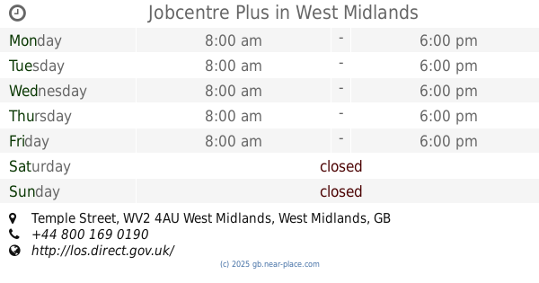
Jobcentre Plus
Molineux House, Temple Street, West Midlands, Wolverhampton
Local government office
read more
14.347 km
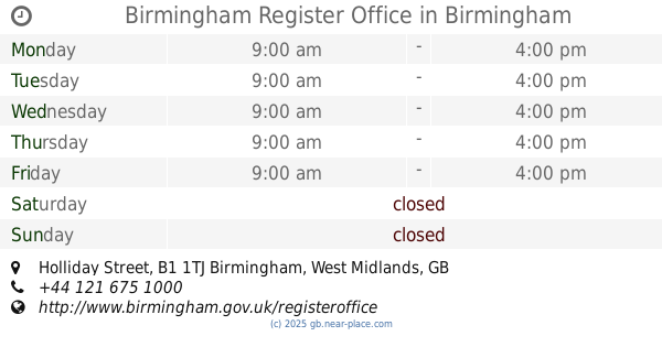
Birmingham Register Office
Holliday Street, Birmingham
Local government office
read more
14.423 km
Wolverhampton City Council - Carer Support
9 North Street, Wolverhampton
Local government office
read more
14.426 km
Highways England
B15 1AY Broad Street, Birmingham
Local government office
read more
14.504 km
Pertemps Wolverhampton Office and Professional
First Floor,, 83 Darlington Street, Wolverhampton
Local government office
read more
14.699 km
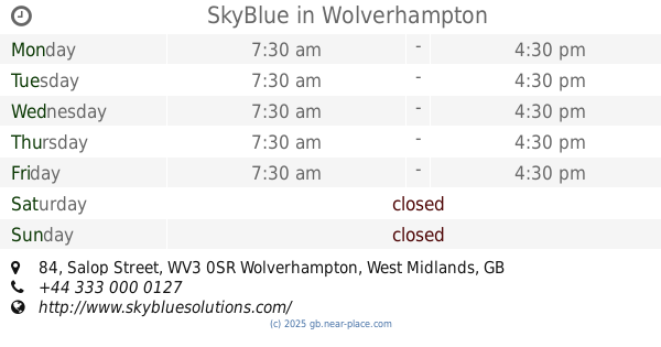
SkyBlue
Carillion House, 84 Salop Street, Wolverhampton
Local government office
read more
16.034 km
Doocey Traffic Management
10/11, Waterside Industrial Estate, Doulton Road, Cradley Heath, Rowley Regis
Local government office
read more
16.595 km
Social Services
Bosworth Centre Auckland Drive, Birmingham
Local government office
read more
18.771 km
Dudley Council Housing Services
Harbour Buildings Waterfront West, Dudley Road, Brierley Hill
Local government office
read more
📑
all categories
Accounting
Administrative area level 1
Administrative area level 2
Airport
Amusement park
Aquarium
Art gallery
Atm
Bakery
Bank
Bar
Beauty salon
Bicycle store
Book store
Bowling alley
Bus station
Cafe
Campground
Car dealer
Car rental
Car repair
Car wash
Casino
Cemetery
Church
City hall
Clothing store
Colloquial area
Convenience store
Courthouse
Dentist
Department store
Doctor
Electrician
Electronics store
Embassy
Establishment
Finance
Fire station
Florist
Food
Funeral home
Furniture store
Gas station
General contractor
Grocery or supermarket
Gym
Hair care
Hardware store
Health
Hindu Temple
Home goods store
Hospital
Insurance agency
Jewelry store
Laundry
Lawyer
Library
Light rail station
Liquor store
Local government office
Locality
Locksmith
Lodging
Meal delivery
Meal takeaway
Mosque
Movie rental
Movie theater
Moving company
Museum
Natural feature
Neighborhood
Night club
Painter
Park
Parking
Pet store
Pharmacy
Physiotherapist
Place of worship
Plumber
Point of interest
Police
Political
Post office
Premise
Real estate agency
Restaurant
Roofing contractor
Route
Rv park, camping
School
Shoe store
Shopping mall
Spa
Stadium
Storage
Store
Subpremise
Subway station
Supermarket
Synagogue
Taxi stand
Train station
Transit station
Travel agency
University
Veterinary care
Zoo
administrative area level 3
administrative area level 4
sublocality level 1
↑