Lodging nearby Duresme
United Kingdom
Lodging nearby Duresme
Duresme
1 Bishops Gate, Durham, Durham United Kingdom
contacts phone
:
+44
Latitude:
54.8013087
, Longitude:
-1.5880877
read more
nearest Lodging
408 m
The Lambton Hounds Inn
62-64 Front Street, Durham
Lodging
read more
656 m
Premier Inn Durham North
Arnison Retail Centre, Rotatory Way, Durham
Lodging
read more
882 m
R S P C A Durham & District
7 Beech Road, Durham
Lodging
read more
912 m
mandys holiday lets
19 Frankland Road, Durham
Lodging
read more
942 m
Durham
9 Finchale Road, Durham
Lodging
read more
1.022 km
Hagg House Farm
Pity Me, Durham
Lodging
read more
1.058 km
Hawthorn House
Durham
Lodging
read more
1.132 km
Durham Moor Crescent
38 Durham Moor Crescent, Durham
Lodging
read more
1.332 km
Staindrop Road
38 Staindrop Road, Durham
Lodging
read more
1.461 km
Sniperley Hall B&B
Durham
Lodging
read more
1.841 km
Bishops Gate Estate
4JU, Bishops Way, Durham
Lodging
read more
1.908 km
Apartment 4 The Grove
Apartment 4, The Grove, Durham
Lodging
read more
1.934 km
Apartment 3 The Grove
Apartment 3, The Grove, Durham
Lodging
read more
2.326 km
The Apartment at Crook Hall and Gardens
Frankland Lane, Durham
Lodging
read more
2.473 km
Self Catering Durham
3 Eureka Mews, Nettlesworth, Tan Hills, Chester le Street
Lodging
read more
2.535 km
Universal Student Living
Ainsley Street, Durham
Lodging
read more
2.562 km
Bridge Hotel
40 North Road, Durham
Lodging
read more
2.595 km
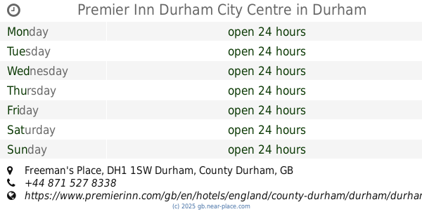
Premier Inn Durham City Centre
Freeman's Place, Durham
Lodging
read more
2.792 km
Durham Cathedral View Suites
Belle Vue Court, Claypath, Durham
Lodging
read more
2.792 km
Plawsworth Hall Farm
Chester-le-street, Plawsworth, Durham
Lodging
read more
2.814 km
Plawsworth Aparthotel
Plawsworth Hall, Plawsworth, Chester le Street
Lodging
read more
2.818 km
21 Neville Street
21 Neville Street, Durham
Lodging
read more
2.872 km
Castle View
4 Crossgate, Durham
Lodging
read more
2.936 km
Travelodge Durham
9 Station Lane, Durham
Lodging
read more
3.085 km
Hotel Indigo Durham
9 Old Elvet, Durham
Lodging
read more
📑
all categories
Accounting
Administrative area level 1
Administrative area level 2
Airport
Amusement park
Aquarium
Art gallery
Atm
Bakery
Bank
Bar
Beauty salon
Bicycle store
Book store
Bowling alley
Bus station
Cafe
Campground
Car dealer
Car rental
Car repair
Car wash
Casino
Cemetery
Church
City hall
Clothing store
Colloquial area
Convenience store
Courthouse
Dentist
Department store
Doctor
Electrician
Electronics store
Embassy
Establishment
Finance
Fire station
Florist
Food
Funeral home
Furniture store
Gas station
General contractor
Grocery or supermarket
Gym
Hair care
Hardware store
Health
Hindu Temple
Home goods store
Hospital
Insurance agency
Jewelry store
Laundry
Lawyer
Library
Light rail station
Liquor store
Local government office
Locality
Locksmith
Lodging
Meal delivery
Meal takeaway
Mosque
Movie rental
Movie theater
Moving company
Museum
Natural feature
Neighborhood
Night club
Painter
Park
Parking
Pet store
Pharmacy
Physiotherapist
Place of worship
Plumber
Point of interest
Police
Political
Post office
Premise
Real estate agency
Restaurant
Roofing contractor
Route
Rv park, camping
School
Shoe store
Shopping mall
Spa
Stadium
Storage
Store
Subpremise
Subway station
Supermarket
Synagogue
Taxi stand
Train station
Transit station
Travel agency
University
Veterinary care
Zoo
administrative area level 3
administrative area level 4
sublocality level 1
↑