Lodging nearby Eagles Nest
United Kingdom
Lodging nearby Eagles Nest
Eagles Nest
1 Craigieholme, North Kessock, Inverness Vereinigtes Königreich
contacts phone
:
+44
Latitude:
57.5076345
, Longitude:
-4.246531
read more
nearest Lodging
29 m
Averon, The Claick
Unnamed Road, Inverness, North Kessock, Inverness
Lodging
read more
621 m
Shoreview
19 Oakleigh Road, North Kessock, Inverness
Lodging
read more
678 m
North Kessock Hotel
Main Street, North Kessock, Inverness
Lodging
read more
721 m
Ardcorran B&B
North Kessock, Inverness
Lodging
read more
730 m
Fishermans
The Sheiling, Old Craigton Road, Scotland
Lodging
read more
732 m
White Cottage
Main Street, Inverness
Lodging
read more
803 m
Shore View Cottage
1 Point rd North Kessock, North Kessock
Lodging
read more
826 m
Mount Pleasant Bed and Breakfast
16 Marine Park, North Kessock, Inverness
Lodging
read more
1.539 km
Culbin Crofthouse
North Kessock, Inverness
Lodging
read more
1.577 km
Cherry Cottage
DRUMSMITTAL NORTH KESSOCK, Inverness
Lodging
read more
1.971 km
Gordon
north, 3 Kessock Avenue, Inverness
Lodging
read more
1.971 km
3 Kessock Court North
north, 3 Kessock Avenue, Inverness
Lodging
read more
2.364 km
Old Drynie House Bed and Breakfast
Old Drynie House, Kilmuir, North Kessock, Inverness
Lodging
read more
2.794 km
Caledonian Canal Studio
5, 90 Telford Street, Inverness
Lodging
read more
2.811 km
Riverview Apartment
Portland Place, Inverness
Lodging
read more
2.821 km
River Ness Apartments
2 Portland Place, Inverness
Lodging
read more
2.874 km
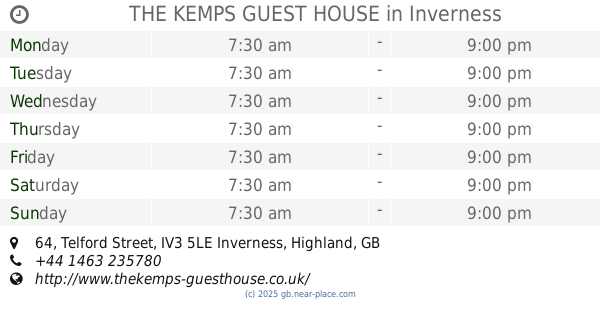
THE KEMPS GUEST HOUSE
64 Telford Street, Inverness
Lodging
read more
2.889 km
Croft Road Garden Annex
15 Croft Road, Inverness
Lodging
read more
2.894 km
Pine Guest House
60 Telford Street, Inverness
Lodging
read more
2.961 km
Craigiewood B&B
North Kessock, Inverness
Lodging
read more
2.995 km
36 George Street
36 George Street, Inverness
Lodging
read more
3.009 km
32a railside
32a Innes Street, Inverness
Lodging
read more
3.02 km
Hillside View, Inverness.
48 Scorguie Drive, Inverness
Lodging
read more
3.057 km
Stanford House
2 Friars Place, Inverness
Lodging
read more
3.746 km
Premier Inn Inverness Centre (Millburn Rd)
Millburn Road, Inverness
Lodging
read more
📑
all categories
Accounting
Administrative area level 1
Administrative area level 2
Airport
Amusement park
Aquarium
Art gallery
Atm
Bakery
Bank
Bar
Beauty salon
Bicycle store
Book store
Bowling alley
Bus station
Cafe
Campground
Car dealer
Car rental
Car repair
Car wash
Casino
Cemetery
Church
City hall
Clothing store
Colloquial area
Convenience store
Courthouse
Dentist
Department store
Doctor
Electrician
Electronics store
Embassy
Establishment
Finance
Fire station
Florist
Food
Funeral home
Furniture store
Gas station
General contractor
Grocery or supermarket
Gym
Hair care
Hardware store
Health
Hindu Temple
Home goods store
Hospital
Insurance agency
Jewelry store
Laundry
Lawyer
Library
Light rail station
Liquor store
Local government office
Locality
Locksmith
Lodging
Meal delivery
Meal takeaway
Mosque
Movie rental
Movie theater
Moving company
Museum
Natural feature
Neighborhood
Night club
Painter
Park
Parking
Pet store
Pharmacy
Physiotherapist
Place of worship
Plumber
Point of interest
Police
Political
Post office
Premise
Real estate agency
Restaurant
Roofing contractor
Route
Rv park, camping
School
Shoe store
Shopping mall
Spa
Stadium
Storage
Store
Subpremise
Subway station
Supermarket
Synagogue
Taxi stand
Train station
Transit station
Travel agency
University
Veterinary care
Zoo
administrative area level 3
administrative area level 4
sublocality level 1
↑