Lodging nearby The Oasis
United Kingdom
Lodging nearby The Oasis
The Oasis
4 Nevill Crescent, Llandudno United Kingdom
contacts phone
:
+44
Latitude:
53.3226464
, Longitude:
-3.8212707
read more
nearest Lodging
The Oasis Hotel in Llandudno
4 Nevill Crescent, Llandudno
Lodging
read more
12 m
Swn-y-Mor Hotel
5 Nevill Crescent, Llandudno
Lodging
read more
47 m
Shelbourne Hotel
Central Promenade, Llandudno
Lodging
read more
54 m
Kinmel Hotel
12 Mostyn Crescent, Llandudno
Lodging
read more
58 m
Kensington Hotel
6-8 Nevill Crescent, Llandudno
Lodging
read more
62 m
The Central Hotel
12 Mostyn Crescent, Llandudno
Lodging
read more
63 m
Can-Y-Bae Hotel
10 Mostyn Crescent, Central Promenade, Llandudno
Lodging
read more
86 m
Hydro Hotel
Nevill Crescent, Llandudno
Lodging
read more
157 m
Four Oaks Hotel
1-4 Penrhyn Crescent, Llandudno
Lodging
read more
182 m
The Broadway Hotel
Mostyn Broadway, Llandudno
Lodging
read more
201 m
Cae Mor Seafront Hotel Llandudno
6 Penrhyn Crescent, Llandudno
Lodging
read more
328 m
Evans Hotel
1 Charlton Street, Llandudno
Lodging
read more
419 m
Lyntara Hotel
7 Oxford Road, Llandudno
Lodging
read more
622 m
Lonsdale House Rentals
1, Lonsdale House, 41 Victoria Street, Llandudno
Lodging
read more
631 m
The Mayfield Hotel
19 Curzon Road, Llandudno
Lodging
read more
645 m
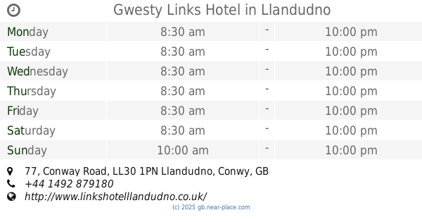
Gwesty Links Hotel
77 Conway Road, Llandudno
Lodging
read more
688 m
Baron Hill Hotel
2 Morley Road, Llandudno
Lodging
read more
695 m
Maesdu Cottage
136 Maesdu Road, Llandudno
Lodging
read more
695 m
Maesdu Cottage
136 Maesdu Road
Lodging
read more
700 m
Royal Manor Park
34 Queen's Road, Llandudno
Lodging
read more
700 m
Royal Manor Park
34 Queen's Road
Lodging
read more
895 m
Lichfield House
Llandudno
Lodging
read more
10.444 km
Tir y Coed Country House
Rowen, Conwy
Lodging
read more
10.57 km
Y Gorlan
High Street, Conwy
Lodging
read more
13.015 km
The Lodge Hotel
4 B5106, Conwy
Lodging
read more
📑
all categories
Accounting
Administrative area level 1
Administrative area level 2
Airport
Amusement park
Aquarium
Art gallery
Atm
Bakery
Bank
Bar
Beauty salon
Bicycle store
Book store
Bowling alley
Bus station
Cafe
Campground
Car dealer
Car rental
Car repair
Car wash
Casino
Cemetery
Church
City hall
Clothing store
Colloquial area
Convenience store
Courthouse
Dentist
Department store
Doctor
Electrician
Electronics store
Embassy
Establishment
Finance
Fire station
Florist
Food
Funeral home
Furniture store
Gas station
General contractor
Grocery or supermarket
Gym
Hair care
Hardware store
Health
Hindu Temple
Home goods store
Hospital
Insurance agency
Jewelry store
Laundry
Lawyer
Library
Light rail station
Liquor store
Local government office
Locality
Locksmith
Lodging
Meal delivery
Meal takeaway
Mosque
Movie rental
Movie theater
Moving company
Museum
Natural feature
Neighborhood
Night club
Painter
Park
Parking
Pet store
Pharmacy
Physiotherapist
Place of worship
Plumber
Point of interest
Police
Political
Post office
Premise
Real estate agency
Restaurant
Roofing contractor
Route
Rv park, camping
School
Shoe store
Shopping mall
Spa
Stadium
Storage
Store
Subpremise
Subway station
Supermarket
Synagogue
Taxi stand
Train station
Transit station
Travel agency
University
Veterinary care
Zoo
administrative area level 3
administrative area level 4
sublocality level 1
↑