Lodging nearby Travelodge Derby Cricket Ground
Coronavirus disease (COVID-19) Situation
confirmed cases
24910387
deaths
232112
United Kingdom
Lodging nearby Travelodge Derby Cricket Ground
Travelodge Derby Cricket Ground
The County Ground, Nottingham Road, Derby United Kingdom
contacts phone
:
+44
Latitude:
52.927041
, Longitude:
-1.4630106
read more
nearest Lodging
612 m
Birchover Liversage House
62-63 Nottingham Road, Derby
Lodging
read more
823 m
Premier Inn Derby City Centre (Riverlights)
Moreledge, Derby
Lodging
read more
838 m
Premier Inn South
Derby
Lodging
read more
883 m
Holiday Inn Derby - Riverlights
Morledge, Derby
Lodging
read more
887 m
Premier Inn Derby City Centre (Cathedral Quarter)
Full Street, Derby
Lodging
read more
926 m
My Rusty
Derby
Lodging
read more
926 m
Jurys Inn Derby
Derby
Lodging
read more
984 m
Where The Car's At
Buchanan Street, Derby
Lodging
read more
994 m
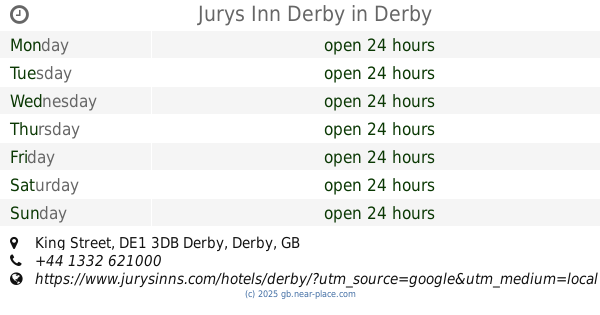
Jurys Inn Derby
King Street, Derby
Lodging
read more
1.164 km
Cathedral Quarter Hotel
16 Saint Mary's Gate, Derby
Lodging
read more
1.256 km
St Peters View
513 Prosperity House, Gower Street, Derby
Lodging
read more
1.276 km
Gemma Properties Ltd
52 Osmaston Road, Derby
Lodging
read more
1.278 km
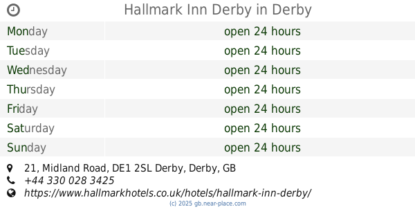
Hallmark Inn Derby
21 Midland Road, Derby
Lodging
read more
1.352 km
St Peters Quarter Hotel
Macklin Street, Derby
Lodging
read more
1.409 km
Pentahotels Derby
Locomotive Way, Derby
Lodging
read more
1.523 km
Abbey Lodge 59 a
69 Abbey Street, Derby
Lodging
read more
1.606 km
Travelodge Derby Pride Park
Prospect Place, Millenium Way, Pride Park, Derby
Lodging
read more
1.607 km
Princess Alice Court
Princess Alice Court, Bridge Street, Derby
Lodging
read more
1.759 km
Dbl En-suite Room
12 Langdale Drive, Derby
Lodging
read more
1.767 km
Birchover Friar Gate
64 Friar Gate, Derby
Lodging
read more
1.95 km
East Midlands Guesthouse
100A Douglas Street, Derby
Lodging
read more
1.963 km
Horsley lodge
Darley Abbey Mills, Derby
Lodging
read more
2.001 km
Georgian House Hotel
Ashbourne Road, Derby
Lodging
read more
2.004 km
Tulip Court
United Kingdom
Lodging
read more
2.539 km
Hillbrook
299-301 Burton Road, Derby
Lodging
read more
📑
all categories
Accounting
Administrative area level 1
Administrative area level 2
Airport
Amusement park
Aquarium
Art gallery
Atm
Bakery
Bank
Bar
Beauty salon
Bicycle store
Book store
Bowling alley
Bus station
Cafe
Campground
Car dealer
Car rental
Car repair
Car wash
Casino
Cemetery
Church
City hall
Clothing store
Colloquial area
Convenience store
Courthouse
Dentist
Department store
Doctor
Electrician
Electronics store
Embassy
Establishment
Finance
Fire station
Florist
Food
Funeral home
Furniture store
Gas station
General contractor
Grocery or supermarket
Gym
Hair care
Hardware store
Health
Hindu Temple
Home goods store
Hospital
Insurance agency
Jewelry store
Laundry
Lawyer
Library
Light rail station
Liquor store
Local government office
Locality
Locksmith
Lodging
Meal delivery
Meal takeaway
Mosque
Movie rental
Movie theater
Moving company
Museum
Natural feature
Neighborhood
Night club
Painter
Park
Parking
Pet store
Pharmacy
Physiotherapist
Place of worship
Plumber
Point of interest
Police
Political
Post office
Premise
Real estate agency
Restaurant
Roofing contractor
Route
Rv park, camping
School
Shoe store
Shopping mall
Spa
Stadium
Storage
Store
Subpremise
Subway station
Supermarket
Synagogue
Taxi stand
Train station
Transit station
Travel agency
University
Veterinary care
Zoo
administrative area level 3
administrative area level 4
sublocality level 1
↑