Lodging nearby Winston Guet House
United Kingdom
Lodging nearby Winston Guet House
Winston Guet House
Banbury Zjednoczone Królestwo
contacts phone
:
+44
Latitude:
52.0581831
, Longitude:
-1.3336861
read more
nearest Lodging
204 m
Treetops Guest House
28 Dashwood Road, Banbury
Lodging
read more
313 m
Fairview House
1 Fairview Road, Banbury
Lodging
read more
330 m
Dashwood Apartments
2 Dashwood Road, Banbury
Lodging
read more
430 m
Banbury Apartment
flat 6 Banbury Chambers Butchers row, Banbury
Lodging
read more
464 m
Mr. Smiths
61 Oxford Road, Banbury
Lodging
read more
466 m
The Lismore Hotel Ltd
61 Oxford Road, Banbury
Lodging
read more
501 m
Easington House
50 Oxford Road, Banbury
Lodging
read more
531 m
Short Let Space Old Town Suites
61A Parson's Street, Banbury
Lodging
read more
533 m
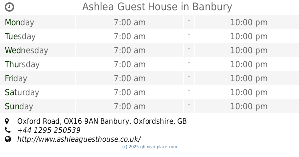
Ashlea Guest House
Ashlea Guest House, 58, Oxford Road, Banbury
Lodging
read more
542 m
Fairlawns Guest House
60 Oxford Road, Banbury
Lodging
read more
570 m
Restaurant at Mercure Banbury Whately Hall Hotel
17-19 Horse Fair, Banbury
Lodging
read more
572 m
Mercure Banbury Whately Hall Hotel
17-19 Horse Fair, Banbury
Lodging
read more
610 m
Prospect Guest House
Prospect House, 70 Oxford Road, Banbury
Lodging
read more
670 m
CREST HOTEL
Banbury
Lodging
read more
670 m
wykham place
Banbury
Lodging
read more
736 m
McCarthy & Stone Yourlife
Foxhall Court, School Lane, Banbury
Lodging
read more
767 m
Banbury Cross Bed & Breakfast
1 Broughton Road, Banbury
Lodging
read more
886 m
Cotefield
17 Saint George's Crescent, Banbury
Lodging
read more
969 m
Avonlea Guest House
41 Southam Road, Banbury
Lodging
read more
1.09 km
Kimbers Ark Guest House Banbury
120 Warwick Road, Banbury
Lodging
read more
1.123 km
Stanbridge House
Ruskin Road, Banbury
Lodging
read more
1.894 km
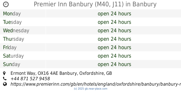
Premier Inn Banbury (M40, J11)
Ermont Way, Banbury
Lodging
read more
1.921 km
The Bowling Green Steakhouse Restaurant & Hotel
Overthorpe Road, Oxfordshire, Banbury
Lodging
read more
2.191 km
Henbury Lodge
Broad Gap, Bodicote, Banbury
Lodging
read more
2.351 km
Rowan Corner
1 Jasmine Walk, Harlequin Way, Banbury
Lodging
read more
📑
all categories
Accounting
Administrative area level 1
Administrative area level 2
Airport
Amusement park
Aquarium
Art gallery
Atm
Bakery
Bank
Bar
Beauty salon
Bicycle store
Book store
Bowling alley
Bus station
Cafe
Campground
Car dealer
Car rental
Car repair
Car wash
Casino
Cemetery
Church
City hall
Clothing store
Colloquial area
Convenience store
Courthouse
Dentist
Department store
Doctor
Electrician
Electronics store
Embassy
Establishment
Finance
Fire station
Florist
Food
Funeral home
Furniture store
Gas station
General contractor
Grocery or supermarket
Gym
Hair care
Hardware store
Health
Hindu Temple
Home goods store
Hospital
Insurance agency
Jewelry store
Laundry
Lawyer
Library
Light rail station
Liquor store
Local government office
Locality
Locksmith
Lodging
Meal delivery
Meal takeaway
Mosque
Movie rental
Movie theater
Moving company
Museum
Natural feature
Neighborhood
Night club
Painter
Park
Parking
Pet store
Pharmacy
Physiotherapist
Place of worship
Plumber
Point of interest
Police
Political
Post office
Premise
Real estate agency
Restaurant
Roofing contractor
Route
Rv park, camping
School
Shoe store
Shopping mall
Spa
Stadium
Storage
Store
Subpremise
Subway station
Supermarket
Synagogue
Taxi stand
Train station
Transit station
Travel agency
University
Veterinary care
Zoo
administrative area level 3
administrative area level 4
sublocality level 1
↑