Meal takeaway nearby Soran
United Kingdom
Meal takeaway nearby Soran
Soran
84 Nethergate, Dundee Reino Unido
contacts phone
:
+44
Latitude:
56.4588699
, Longitude:
-2.9724039
read more
nearest Meal takeaway
35 m
Shaheen
102 Nethergate, Dundee
Meal takeaway
read more
133 m
The Snack Stop
19 Whitehall Crescent, Dundee
Meal takeaway
read more
139 m
Five Guys
L17 Overgate Shopping Centre, Dundee
Meal takeaway
read more
144 m
Tailend Dundee
81 Nethergate, Dundee
Meal takeaway
read more
147 m
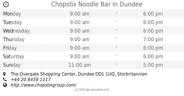
Chopstix Noodle Bar
The Overgate Shopping Center, Dundee
Meal takeaway
read more
200 m
Scots Hoose
3 Whitehall Crescent, Dundee
Meal takeaway
read more
274 m
Super Snack
133 Nethergate, Dundee
Meal takeaway
read more
313 m
Milano Pizza
70 North Lindsay Street, Dundee
Meal takeaway
read more
320 m
La Baguette
54 South Tay Street, Dundee
Meal takeaway
read more
330 m
Corfu Kebabs
74 North Lindsay Street, Dundee
Meal takeaway
read more
349 m
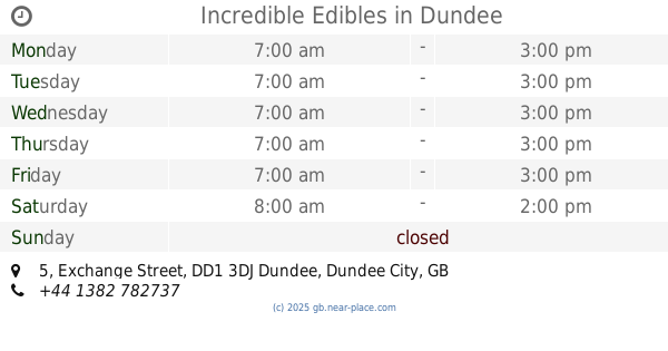
Incredible Edibles
5 Exchange Street, Dundee
Meal takeaway
read more
395 m
Marco Polo
3 Hawkhill, Dundee
Meal takeaway
read more
429 m
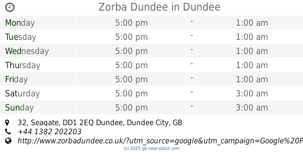
Zorba Dundee
32 Seagate, Dundee
Meal takeaway
read more
429 m
Pizza de Roma
32 Seagate, Dundee
Meal takeaway
read more
510 m
Fairuz
8 Panmure Street, Dundee
Meal takeaway
read more
517 m
Brodie's
70 Bell Street, Dundee
Meal takeaway
read more
599 m
McDonald's
16 The Wellgate, Dundee
Meal takeaway
read more
623 m
Burger King
12-15 Panmure Street, Dundee
Meal takeaway
read more
625 m
Munchies
79 Meadowside, Dundee
Meal takeaway
read more
633 m
The Popular
14 Saint Andrew's Street, Dundee
Meal takeaway
read more
634 m
The Bus Stop Takeaway
Seagate, Dundee
Meal takeaway
read more
708 m
Scoff Takeaway
1 Douglas Street, Dundee
Meal takeaway
read more
722 m
Food Anarchy
142 Perth Road, Dundee
Meal takeaway
read more
900 m
Food Temple
124A Hilltown, Dundee
Meal takeaway
read more
976 m
Alisha Indian Spice Dundee
67 Perth Road, Dundee
Meal takeaway
read more
📑
all categories
Accounting
Administrative area level 1
Administrative area level 2
Airport
Amusement park
Aquarium
Art gallery
Atm
Bakery
Bank
Bar
Beauty salon
Bicycle store
Book store
Bowling alley
Bus station
Cafe
Campground
Car dealer
Car rental
Car repair
Car wash
Casino
Cemetery
Church
City hall
Clothing store
Colloquial area
Convenience store
Courthouse
Dentist
Department store
Doctor
Electrician
Electronics store
Embassy
Establishment
Finance
Fire station
Florist
Food
Funeral home
Furniture store
Gas station
General contractor
Grocery or supermarket
Gym
Hair care
Hardware store
Health
Hindu Temple
Home goods store
Hospital
Insurance agency
Jewelry store
Laundry
Lawyer
Library
Light rail station
Liquor store
Local government office
Locality
Locksmith
Lodging
Meal delivery
Meal takeaway
Mosque
Movie rental
Movie theater
Moving company
Museum
Natural feature
Neighborhood
Night club
Painter
Park
Parking
Pet store
Pharmacy
Physiotherapist
Place of worship
Plumber
Point of interest
Police
Political
Post office
Premise
Real estate agency
Restaurant
Roofing contractor
Route
Rv park, camping
School
Shoe store
Shopping mall
Spa
Stadium
Storage
Store
Subpremise
Subway station
Supermarket
Synagogue
Taxi stand
Train station
Transit station
Travel agency
University
Veterinary care
Zoo
administrative area level 3
administrative area level 4
sublocality level 1
↑