Night club nearby Night Club
United Kingdom
Night club nearby Night Club
Night Club
B4205, Worcester United Kingdom
contacts phone
:
+44
Latitude:
52.1934435
, Longitude:
-2.2256405
read more
nearest Night club
107 m
The Velvet Lounge
Angel Place, Worcester, Worcestershire County
Night club
read more
167 m
Tramps Night Club
Angel Place, Worcester
Night club
read more
263 m
Worcester Bridge Pop-up Bar and Nightclub
A44, Worcester
Night club
read more
374 m
Bushwackers
Trinity St, Worcester
Night club
read more
603 m
The Flag
50 Lowesmoor, Worcester
Night club
read more
841 m
Earl Marsh Boat Trips
Unnamed Road, Worcester
Night club
read more
2.918 km
Fatal Floor Productions
411 Tolladine Road, Worcester
Night club
read more
19.764 km
Time 2 Disco
79 Winslow Road, Bromyard
Night club
read more
22.271 km
Riki Parker
5 Pennyford Close, Redditch
Night club
read more
22.911 km
Golden Cross
56 Hewell Road, Redditch
Night club
read more
31.162 km
Mahfil Lounge
68-69 The Green, Birmingham
Night club
read more
36.763 km
Club Advizor
104 Wake Green Road, Birmingham
Night club
read more
37.758 km
Legs 11 Broad Street
193-194 Broad Street, Birmingham
Night club
read more
37.935 km
Nuvo
Eleven Brindley Place, 2 Brunswick Square, Birmingham
Night club
read more
38.288 km
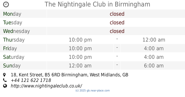
The Nightingale Club
18 Kent Street, Birmingham
Night club
read more
38.496 km
Sobar
86 Hurst Street, Birmingham
Night club
read more
38.846 km
Warstone centre
154 Warstone Lane, Birmingham
Night club
read more
41.587 km
Cvhjdjsbsbsbsnz
12-1 Ermington Road, Wolverhampton
Night club
read more
42.279 km
Stus
112 Upper Villiers Street, Wolverhampton
Night club
read more
43.905 km
I
Bromford Road, Birmingham
Night club
read more
44.132 km
Outback Wolverhampton
50 Queen Street, Wolverhampton
Night club
read more
45.004 km
Club Maragh
197 High Street, Birmingham
Night club
read more
45.394 km
PerfectSoundswm
Flat 2, Short Heath Court 1 Short Heath Road, Birmingham
Night club
read more
52.159 km
Bel Air Night Club & Lounge
The Belfry Hotel & Resort, Lichfield Road, Wishaw
Night club
read more
53.778 km
Arabella Lounge
181 Spon Street, Coventry
Night club
read more
📑
all categories
Accounting
Administrative area level 1
Administrative area level 2
Airport
Amusement park
Aquarium
Art gallery
Atm
Bakery
Bank
Bar
Beauty salon
Bicycle store
Book store
Bowling alley
Bus station
Cafe
Campground
Car dealer
Car rental
Car repair
Car wash
Casino
Cemetery
Church
City hall
Clothing store
Colloquial area
Convenience store
Courthouse
Dentist
Department store
Doctor
Electrician
Electronics store
Embassy
Establishment
Finance
Fire station
Florist
Food
Funeral home
Furniture store
Gas station
General contractor
Grocery or supermarket
Gym
Hair care
Hardware store
Health
Hindu Temple
Home goods store
Hospital
Insurance agency
Jewelry store
Laundry
Lawyer
Library
Light rail station
Liquor store
Local government office
Locality
Locksmith
Lodging
Meal delivery
Meal takeaway
Mosque
Movie rental
Movie theater
Moving company
Museum
Natural feature
Neighborhood
Night club
Painter
Park
Parking
Pet store
Pharmacy
Physiotherapist
Place of worship
Plumber
Point of interest
Police
Political
Post office
Premise
Real estate agency
Restaurant
Roofing contractor
Route
Rv park, camping
School
Shoe store
Shopping mall
Spa
Stadium
Storage
Store
Subpremise
Subway station
Supermarket
Synagogue
Taxi stand
Train station
Transit station
Travel agency
University
Veterinary care
Zoo
administrative area level 3
administrative area level 4
sublocality level 1
↑