Night club nearby Popworld
Coronavirus disease (COVID-19) Situation
confirmed cases
24910387
deaths
232112
United Kingdom
Night club nearby Popworld
Popworld
13 Church Street, Preston United Kingdom
contacts phone
:
+44
Latitude:
53.7587018
, Longitude:
-2.6970577
read more
nearest Night club
47 m
Yates
144-146 Church Street, Preston
Night club
read more
90 m
Evoque
151 Church Street, Preston
Night club
read more
114 m
The Ritz
134 Church Street, Preston
Night club
read more
115 m
The Warehouse Nightclub
50 Saint John's Place, Preston
Night club
read more
257 m
Fives
49 Guildhall Street, Preston
Night club
read more
265 m
Oblivion Bar
12-14 Back Grimshaw Street, Preston
Night club
read more
347 m
Switch Nightclub
Market Street, Preston
Night club
read more
414 m
Perfect 10s
10 Lune Street, Preston
Night club
read more
1.53 km
Tang Restaurant
241 Fylde Road, Preston
Night club
read more
1.775 km
Chateau Albi
8 Buller Avenue, Penwortham, Preston
Night club
read more
2.336 km
keemstar
117-125, Holme Slack Lane, Preston
Night club
read more
2.447 km
Mobile Disco Preston
249 Tulketh Brow, Preston
Night club
read more
6.979 km
The Asylum
5 Herbert Street, Leyland
Night club
read more
12.33 km
Applejax
Market Street, Chorley
Night club
read more
14.125 km
Switch
Saint Peter Street, Blackburn
Night club
read more
20.392 km
Rendezvous Nightclub
16 Accrington Road, Clitheroe
Night club
read more
21.115 km
Rhinestone Country Music Club
Wren Rovers Football Club, School Road, Blackpool
Night club
read more
23.478 km
Blackpool Rox Entertainment Group
76 Devonshire Road, Blackpool
Night club
read more
24.208 km
Gaietys Bar
169 Promenade, Blackpool
Night club
read more
24.345 km
The Tache Rock Club
22 Coronation Street, Blackpool
Night club
read more
24.345 km
Blue Nightclub
22 Corporation Street, Blackpool
Night club
read more
24.346 km
The Tache Rock Club
22 Corporation Street, Blackpool
Night club
read more
24.489 km
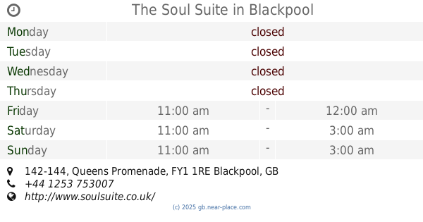
The Soul Suite
142-144 Queens Promenade, Blackpool
Night club
read more
24.49 km
Club Domain
168-170 Promenade, Blackpool
Night club
read more
24.495 km
Nellie Deans
150-152 Promenade, Blackpool
Night club
read more
📑
all categories
Accounting
Administrative area level 1
Administrative area level 2
Airport
Amusement park
Aquarium
Art gallery
Atm
Bakery
Bank
Bar
Beauty salon
Bicycle store
Book store
Bowling alley
Bus station
Cafe
Campground
Car dealer
Car rental
Car repair
Car wash
Casino
Cemetery
Church
City hall
Clothing store
Colloquial area
Convenience store
Courthouse
Dentist
Department store
Doctor
Electrician
Electronics store
Embassy
Establishment
Finance
Fire station
Florist
Food
Funeral home
Furniture store
Gas station
General contractor
Grocery or supermarket
Gym
Hair care
Hardware store
Health
Hindu Temple
Home goods store
Hospital
Insurance agency
Jewelry store
Laundry
Lawyer
Library
Light rail station
Liquor store
Local government office
Locality
Locksmith
Lodging
Meal delivery
Meal takeaway
Mosque
Movie rental
Movie theater
Moving company
Museum
Natural feature
Neighborhood
Night club
Painter
Park
Parking
Pet store
Pharmacy
Physiotherapist
Place of worship
Plumber
Point of interest
Police
Political
Post office
Premise
Real estate agency
Restaurant
Roofing contractor
Route
Rv park, camping
School
Shoe store
Shopping mall
Spa
Stadium
Storage
Store
Subpremise
Subway station
Supermarket
Synagogue
Taxi stand
Train station
Transit station
Travel agency
University
Veterinary care
Zoo
administrative area level 3
administrative area level 4
sublocality level 1
↑