School nearby Coatham Primary School
United Kingdom
School nearby Coatham Primary School
Coatham Primary School
Coatham Road, Redcar United Kingdom
contacts phone
:
+44
Latitude:
54.6164397
, Longitude:
-1.0828828
read more
nearest School
1 m
Coatham Church of England Primary School
45 Kirkleatham Street, Redcar
School
read more
595 m
John Robson Guitar Tuition
88 Peirson Street, Redcar
School
read more
708 m
Little Legs Day Nursery
70 Thames Road, Redcar
School
read more
726 m
Sunshine Day Nurseries
4 Clifford Street, Redcar
School
read more
789 m
Redlands Private
Redlands House, 4 Kirkleatham Street, Redcar
School
read more
1.518 km
Lakeside Children’s Centre
West Dyke Road, Redcar
School
read more
1.546 km
South Avenue Nursery
South Avenue, Redcar
School
read more
2.019 km
Yoga with Sally.
Zetland Park Methodist Church, The Crescent, Redcar
School
read more
2.192 km
Rye Hills Academy
Redcar Lane, Redcar
School
read more
3.127 km
Kirkleatham Hall School
Kirkleatham Hall School, Kirkleatham Village, Redcar
School
read more
6.206 km
Grangetown Primary School
Saint Georges Road West, Grangetown, Middlesbrough
School
read more
6.338 km
Tigertots Community Day Nursery
Grange Farm Road, Middlesbrough
School
read more
6.356 km
St Mary's R C Primary School
Tennyson Avenue, Middlesbrough
School
read more
6.362 km
The Priory Day Nursery
18 Grange Close, Middlesbrough
School
read more
6.429 km
Pathways School
Tennyson Avenue, Grangetown, Middlesbrough
School
read more
12.285 km
Holmwood School
Saltersgill Avenue, Middlesbrough
School
read more
12.643 km
Lingfield Primary School
Buxton Avenue, Marton-in-Cleveland, Middlesbrough
School
read more
12.837 km
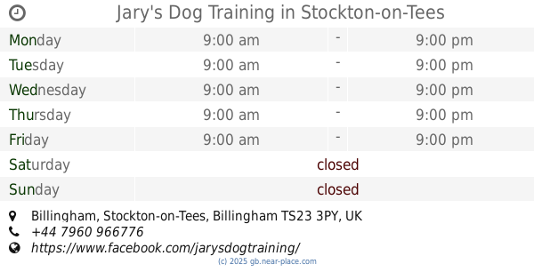
Jary's Dog Training
Billingham, Stockton-on-Tees
School
read more
13.683 km
West Middlesbrough Children's Centre
Stainsby Road, Middlesbrough
School
read more
13.919 km
Lingfield Choosing Pathways
Coulby Newham, Middlesbrough
School
read more
14.072 km
Kader Primary School
21 Staindrop Drive, Middlesbrough
School
read more
14.951 km
A.D. Norton Board Schools.
16 High Street, Stockton-on-Tees
School
read more
15.696 km
Mandale Mill Primary School
Thorntree Road, Thornaby, Stockton-on-Tees
School
read more
16.084 km
Westlands School
Stockton-on-Tees
School
read more
17.791 km
Whinstone Primary School
60 Lowfields Avenue, Stockton-on-Tees
School
read more
📑
all categories
Accounting
Administrative area level 1
Administrative area level 2
Airport
Amusement park
Aquarium
Art gallery
Atm
Bakery
Bank
Bar
Beauty salon
Bicycle store
Book store
Bowling alley
Bus station
Cafe
Campground
Car dealer
Car rental
Car repair
Car wash
Casino
Cemetery
Church
City hall
Clothing store
Colloquial area
Convenience store
Courthouse
Dentist
Department store
Doctor
Electrician
Electronics store
Embassy
Establishment
Finance
Fire station
Florist
Food
Funeral home
Furniture store
Gas station
General contractor
Grocery or supermarket
Gym
Hair care
Hardware store
Health
Hindu Temple
Home goods store
Hospital
Insurance agency
Jewelry store
Laundry
Lawyer
Library
Light rail station
Liquor store
Local government office
Locality
Locksmith
Lodging
Meal delivery
Meal takeaway
Mosque
Movie rental
Movie theater
Moving company
Museum
Natural feature
Neighborhood
Night club
Painter
Park
Parking
Pet store
Pharmacy
Physiotherapist
Place of worship
Plumber
Point of interest
Police
Political
Post office
Premise
Real estate agency
Restaurant
Roofing contractor
Route
Rv park, camping
School
Shoe store
Shopping mall
Spa
Stadium
Storage
Store
Subpremise
Subway station
Supermarket
Synagogue
Taxi stand
Train station
Transit station
Travel agency
University
Veterinary care
Zoo
administrative area level 3
administrative area level 4
sublocality level 1
↑