Stadium nearby Broadstreet Rugby Football Club
United Kingdom
Stadium nearby Broadstreet Rugby Football Club
Broadstreet Rugby Football Club
The Ivor Preece Centre, 105 Rugby Road, Binley Woods, Coventry United Kingdom
contacts phone
:
+44
Latitude:
52.396625
, Longitude:
-1.429917
read more
nearest Stadium
6.558 km
Coventry Rugby Club
Butts Park Arena, Butts Road, Coventry
Stadium
read more
6.558 km
Coventry Rugby Club
4401 Butts Road, Coventry
Stadium
read more
7.317 km
Ricoh Arena
Judds Lane, Coventry
Stadium
read more
20.421 km
Tower Deck Restaurant & Bar
Marston Green, Birmingham
Stadium
read more
28.224 km
Hall Green Greyhound Stadium
York Road, Hall Green, Birmingham
Stadium
read more
28.944 km
ben trulli memorial stadium
Asda Small Heath, 859 Coventry Road, Birmingham
Stadium
read more
30.327 km
Leicestershire County Cricket Club
Grace Road, Leicester
Stadium
read more
30.914 km
Kop Corner Stand
10 Tilton Road, Birmingham
Stadium
read more
30.972 km
St Andrew’s Trillion Trophy Stadium
Cattell Road, Birmingham
Stadium
read more
30.972 km
Audi Stadium
7 South Holme, Birmingham
Stadium
read more
30.972 km
St. Andrew's Stadium
Cattell Road, Birmingham
Stadium
read more
31.367 km
Saffron Lane Athletics Stadium
Saffron Lane, Leicester
Stadium
read more
31.589 km
King Power Stadium
Filbert Way, Leicester
Stadium
read more
32.72 km
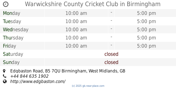
Warwickshire County Cricket Club
Edgbaston Stadium, Edgbaston Road, Birmingham
Stadium
read more
33.26 km
Villa Park
Trinity Road, Birmingham
Stadium
read more
33.326 km
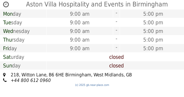
Aston Villa Hospitality and Events
218 Witton Lane, Birmingham
Stadium
read more
34.155 km
Arena Birmingham
King Edwards Road, Birmingham
Stadium
read more
34.575 km
Perry Barr Greyhound Stadium
Aldridge Road, Birmingham
Stadium
read more
35.471 km
Metchley Park Sports Pitches
126 Metchley Lane, Birmingham
Stadium
read more
47.024 km
C R Leisure
110 Rugeley Road, Burntwood
Stadium
read more
48.366 km
Donington Park Circuit
Donington Park, Castle Donington, Derby
Stadium
read more
52.076 km
Molineux Stadium
Waterloo Road, Wolverhampton
Stadium
read more
52.12 km
Billy Wright Stand
Molineux Stadium, Waterloo Road, Wolverhampton
Stadium
read more
53.597 km
SIXWAYS STADIUM
Warriors Way, Worcester
Stadium
read more
54.018 km
WV Active Aldersley
Aldersley Road, Wolverhampton
Stadium
read more
📑
all categories
Accounting
Administrative area level 1
Administrative area level 2
Airport
Amusement park
Aquarium
Art gallery
Atm
Bakery
Bank
Bar
Beauty salon
Bicycle store
Book store
Bowling alley
Bus station
Cafe
Campground
Car dealer
Car rental
Car repair
Car wash
Casino
Cemetery
Church
City hall
Clothing store
Colloquial area
Convenience store
Courthouse
Dentist
Department store
Doctor
Electrician
Electronics store
Embassy
Establishment
Finance
Fire station
Florist
Food
Funeral home
Furniture store
Gas station
General contractor
Grocery or supermarket
Gym
Hair care
Hardware store
Health
Hindu Temple
Home goods store
Hospital
Insurance agency
Jewelry store
Laundry
Lawyer
Library
Light rail station
Liquor store
Local government office
Locality
Locksmith
Lodging
Meal delivery
Meal takeaway
Mosque
Movie rental
Movie theater
Moving company
Museum
Natural feature
Neighborhood
Night club
Painter
Park
Parking
Pet store
Pharmacy
Physiotherapist
Place of worship
Plumber
Point of interest
Police
Political
Post office
Premise
Real estate agency
Restaurant
Roofing contractor
Route
Rv park, camping
School
Shoe store
Shopping mall
Spa
Stadium
Storage
Store
Subpremise
Subway station
Supermarket
Synagogue
Taxi stand
Train station
Transit station
Travel agency
University
Veterinary care
Zoo
administrative area level 3
administrative area level 4
sublocality level 1
↑