Supermarket nearby ALDI Heswall
Coronavirus disease (COVID-19) Situation
confirmed cases
24910387
deaths
232112
United Kingdom
Supermarket nearby ALDI Heswall
ALDI Heswall
May Road, Heswall, Wirral United Kingdom
contacts phone
:
+44
Latitude:
53.3292513
, Longitude:
-3.096887
read more
nearest Supermarket
200 m
Iceland Foods
176 Telegraph Road, Heswall, Wirral
Supermarket
read more
408 m
Tesco Superstore
Telegraph Road, Heswall, Wirral
Supermarket
read more
1.683 km
Tesco Express
323-327 Pensby Road, Heswall, Wirral
Supermarket
read more
2.114 km
The Co-operative Food
415 Pensby Road, Heswall, Wirral
Supermarket
read more
4.636 km
RaanThai Oriental Supermarket
A2, North Cheshire Trading Estate, Prenton Way, Prenton
Supermarket
read more
4.73 km
Arrowe Park Asda,
Birkenhead, Wirral
Supermarket
read more
4.752 km
Asda Arrowe Park Superstore
Woodchurch Road, Birkenhead, Wirral
Supermarket
read more
4.752 km
Asda Arrowe Park Superstore
Woodchurch Road, Birkenhead
Supermarket
read more
4.831 km
Sainsbury's
Brook Street, Neston
Supermarket
read more
4.9 km
Tesco Express
4 The Cross, Neston, South Wirral
Supermarket
read more
5.615 km
Sainsbury's Petrol Station
152 King's Road, Bebington, Wirral
Supermarket
read more
5.637 km
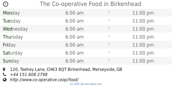
The Co-operative Food
120 Teehey Lane, Birkenhead, Wirral
Supermarket
read more
5.879 km
Home Bargains
374-376 Woodchurch Road, Birkenhead
Supermarket
read more
5.894 km
Aldi
374 Woodchurch Road, Prenton
Supermarket
read more
5.966 km
Sainsbury's
342A Woodchurch Road, Birkenhead
Supermarket
read more
6.415 km
Londis
115-117 Mount Road, Birkenhead
Supermarket
read more
8.57 km
Iceland Foods
2 Stanley Road, Birkenhead
Supermarket
read more
8.921 km
Tesco Scan As You Shop
Bidston Village Road, Birkenhead
Supermarket
read more
10.771 km
Tesco
215 Park Road, Liverpool
Supermarket
read more
11.184 km
The Gallery
37 North John Street, Liverpool
Supermarket
read more
11.428 km
Tesco Metro
Clayton Lane, Liverpool
Supermarket
read more
13.358 km
Golocalextra
84 Saint Mary's Road, Garston, Liverpool
Supermarket
read more
13.984 km
Iceland Foods
158 Allerton Road, Liverpool
Supermarket
read more
15.036 km
Northway Newz 2 The Parade, Liverpool
93 Northway, Liverpool
Supermarket
read more
20.465 km
International Supermarket
54-58 Brook Street, Chester
Supermarket
read more
📑
all categories
Accounting
Administrative area level 1
Administrative area level 2
Airport
Amusement park
Aquarium
Art gallery
Atm
Bakery
Bank
Bar
Beauty salon
Bicycle store
Book store
Bowling alley
Bus station
Cafe
Campground
Car dealer
Car rental
Car repair
Car wash
Casino
Cemetery
Church
City hall
Clothing store
Colloquial area
Convenience store
Courthouse
Dentist
Department store
Doctor
Electrician
Electronics store
Embassy
Establishment
Finance
Fire station
Florist
Food
Funeral home
Furniture store
Gas station
General contractor
Grocery or supermarket
Gym
Hair care
Hardware store
Health
Hindu Temple
Home goods store
Hospital
Insurance agency
Jewelry store
Laundry
Lawyer
Library
Light rail station
Liquor store
Local government office
Locality
Locksmith
Lodging
Meal delivery
Meal takeaway
Mosque
Movie rental
Movie theater
Moving company
Museum
Natural feature
Neighborhood
Night club
Painter
Park
Parking
Pet store
Pharmacy
Physiotherapist
Place of worship
Plumber
Point of interest
Police
Political
Post office
Premise
Real estate agency
Restaurant
Roofing contractor
Route
Rv park, camping
School
Shoe store
Shopping mall
Spa
Stadium
Storage
Store
Subpremise
Subway station
Supermarket
Synagogue
Taxi stand
Train station
Transit station
Travel agency
University
Veterinary care
Zoo
administrative area level 3
administrative area level 4
sublocality level 1
↑