Supermarket nearby Cooltrader
United Kingdom
Supermarket nearby Cooltrader
Cooltrader
4 Westway, Maghull, Liverpool Zjednoczone Królestwo
contacts phone
:
+44
Latitude:
53.5166069
, Longitude:
-2.941279
read more
nearest Supermarket
3 m
Heron Foods
4 Westway, Maghull, Liverpool
Supermarket
read more
207 m
Morrisons
1 Stafford Moreton Way, Maghull, Liverpool
Supermarket
read more
593 m
The Co-operative Food
99 Deyes Lane, Liverpool
Supermarket
read more
1.563 km
Iceland Foods
110 Northway, Maghull, Liverpool
Supermarket
read more
1.757 km
Lidl
72 Northway, Liverpool
Supermarket
read more
1.823 km
Londis
232 Southport Road, Lydiate, Liverpool
Supermarket
read more
2.924 km
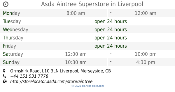
Asda Aintree Superstore
Ormskirk Road, Liverpool
Supermarket
read more
3.033 km
Londis
A506, Melling, Liverpool
Supermarket
read more
3.484 km
Tesco Express
6-10 Molyneux Way, Liverpool
Supermarket
read more
3.8 km
Home Bargains
1 The Marian Square, Bootle
Supermarket
read more
3.856 km
Iceland Foods
8-10 The Marian Square, Bootle
Supermarket
read more
4.137 km
Londis
Dunnings Bridge Road, Liverpool
Supermarket
read more
4.186 km
ALDI Netherton
Park Lane West, Netherton
Supermarket
read more
4.186 km
ALDI Netherton
Park Lane West, Bootle
Supermarket
read more
4.2 km
Costcutter
3 Loweswater Way, Liverpool
Supermarket
read more
4.206 km
shop
20 Fleetwood's Lane, Bootle
Supermarket
read more
4.468 km
Heron Foods
23-25 Marian Square, Netherton, Bootle, Liverpool
Supermarket
read more
4.554 km
Tesco Express
Edge Lane, Little Crosby, Liverpool
Supermarket
read more
4.596 km
Dale Acre Store
39 Dale Acre Drive, Bootle
Supermarket
read more
4.646 km
Londis
7 The Crescent, Thornton, Liverpool
Supermarket
read more
4.737 km
Aldi
Moor Lane, Thornton, Thornton, Crosby
Supermarket
read more
5.186 km
Iceland Foods
31 Saint Chad's Drive, Kirkby, Liverpool
Supermarket
read more
5.265 km
Home Bargains
20 Saint Chad's Drive, Liverpool
Supermarket
read more
5.341 km
Heron Foods
148-150 Cherryfield Drive, Kirkby, Liverpool
Supermarket
read more
12.612 km
Tesco Metro
Clayton Lane, Liverpool
Supermarket
read more
📑
all categories
Accounting
Administrative area level 1
Administrative area level 2
Airport
Amusement park
Aquarium
Art gallery
Atm
Bakery
Bank
Bar
Beauty salon
Bicycle store
Book store
Bowling alley
Bus station
Cafe
Campground
Car dealer
Car rental
Car repair
Car wash
Casino
Cemetery
Church
City hall
Clothing store
Colloquial area
Convenience store
Courthouse
Dentist
Department store
Doctor
Electrician
Electronics store
Embassy
Establishment
Finance
Fire station
Florist
Food
Funeral home
Furniture store
Gas station
General contractor
Grocery or supermarket
Gym
Hair care
Hardware store
Health
Hindu Temple
Home goods store
Hospital
Insurance agency
Jewelry store
Laundry
Lawyer
Library
Light rail station
Liquor store
Local government office
Locality
Locksmith
Lodging
Meal delivery
Meal takeaway
Mosque
Movie rental
Movie theater
Moving company
Museum
Natural feature
Neighborhood
Night club
Painter
Park
Parking
Pet store
Pharmacy
Physiotherapist
Place of worship
Plumber
Point of interest
Police
Political
Post office
Premise
Real estate agency
Restaurant
Roofing contractor
Route
Rv park, camping
School
Shoe store
Shopping mall
Spa
Stadium
Storage
Store
Subpremise
Subway station
Supermarket
Synagogue
Taxi stand
Train station
Transit station
Travel agency
University
Veterinary care
Zoo
administrative area level 3
administrative area level 4
sublocality level 1
↑