Supermarket nearby Farmfoods Ltd
United Kingdom
Supermarket nearby Farmfoods Ltd
Farmfoods Ltd
Unit 1B, The Calthorpe Centre, Banbury Vereinigtes Königreich
contacts phone
:
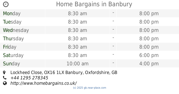
+44
Latitude:
52.0592282
, Longitude:
-1.3380548
read more
nearest Supermarket
79 m
Iceland Foods
56-60 Calthorpe Street, Banbury
Supermarket
read more
139 m
New Ploski Hypermarket
35 High Street, Banbury
Supermarket
read more
179 m
Tesco Express
23 High Street, Banbury
Supermarket
read more
308 m
Bao Giang Oriental Supermarket
26 Parson's Street, Banbury
Supermarket
read more
322 m
Tai Oriental Supermarket
40-41 Parson's Street, Banbury
Supermarket
read more
482 m
Morrisons
1 Swan Close Road, Banbury
Supermarket
read more
868 m
SimplyLocal
35-39 Middleton Road, Banbury
Supermarket
read more
1.006 km
Sainsbury's
Oxford Road, Banbury
Supermarket
read more
1.099 km
Waitrose
Southam Road, Banbury
Supermarket
read more
1.34 km
The Midcounties Co-operative
75-77 Chatsworth Drive, Banbury
Supermarket
read more
1.353 km
Tesco Express
1-2 Blacklock House, Middleton Rd, Banbury
Supermarket
read more
1.409 km
Aldi
Ruscote Avenue, Banbury
Supermarket
read more
1.51 km
The Midcounties Co-operative
3 Burchester Place, Banbury
Supermarket
read more
1.511 km
The Midcounties Co-operative
Ruscote Arcade, 6 Longelandes Way, Banbury
Supermarket
read more
1.569 km
Tesco Extra
Lockheed Close, Banbury
Supermarket
read more
1.623 km
The Food Warehouse by Iceland
3, Banbury Cross Retail Park, Lockheed Close, Banbury
Supermarket
read more
1.697 km
Home Bargains
Banbury Cross Retail Park, Lockheed Close, Banbury
Supermarket
read more
1.82 km
Londis
2-5, Bradley Arcade, Bretch Hill, Banbury
Supermarket
read more
1.826 km
The Italian Larder
Wildmere Industrial Estate, 18 Wildmere Road, Banbury
Supermarket
read more
2.096 km
Co-op
60 Ferriston, Banbury
Supermarket
read more
12.855 km
Tesco Express
Pavillons Way, Brackley
Supermarket
read more
13.267 km
Waitrose
Manor Road, Brackley
Supermarket
read more
13.373 km
Tesco Superstore
Oxford Road, Brackley
Supermarket
read more
14.897 km
Midcounties Co-operative
Phipps Road, Daventry
Supermarket
read more
15.869 km
Londis
3 Banbury Street, Kineton, Warwick
Supermarket
read more
📑
all categories
Accounting
Administrative area level 1
Administrative area level 2
Airport
Amusement park
Aquarium
Art gallery
Atm
Bakery
Bank
Bar
Beauty salon
Bicycle store
Book store
Bowling alley
Bus station
Cafe
Campground
Car dealer
Car rental
Car repair
Car wash
Casino
Cemetery
Church
City hall
Clothing store
Colloquial area
Convenience store
Courthouse
Dentist
Department store
Doctor
Electrician
Electronics store
Embassy
Establishment
Finance
Fire station
Florist
Food
Funeral home
Furniture store
Gas station
General contractor
Grocery or supermarket
Gym
Hair care
Hardware store
Health
Hindu Temple
Home goods store
Hospital
Insurance agency
Jewelry store
Laundry
Lawyer
Library
Light rail station
Liquor store
Local government office
Locality
Locksmith
Lodging
Meal delivery
Meal takeaway
Mosque
Movie rental
Movie theater
Moving company
Museum
Natural feature
Neighborhood
Night club
Painter
Park
Parking
Pet store
Pharmacy
Physiotherapist
Place of worship
Plumber
Point of interest
Police
Political
Post office
Premise
Real estate agency
Restaurant
Roofing contractor
Route
Rv park, camping
School
Shoe store
Shopping mall
Spa
Stadium
Storage
Store
Subpremise
Subway station
Supermarket
Synagogue
Taxi stand
Train station
Transit station
Travel agency
University
Veterinary care
Zoo
administrative area level 3
administrative area level 4
sublocality level 1
↑