Supermarket nearby Londis Coltishall
Coronavirus disease (COVID-19) Situation
confirmed cases
24910387
deaths
232112
United Kingdom
Supermarket nearby Londis Coltishall
Londis Coltishall
10 High Street, Coltishall, Norwich United Kingdom
contacts phone
:
+44
Latitude:
52.7281209
, Longitude:
1.3583128
read more
nearest Supermarket
3.909 km
Thorougoods Select Convenience & Post Office with Hairbase hair salon
Lamas Road, Badersfield, Norwich
Supermarket
read more
3.931 km
Roys of Wroxham Food Hall
Stalham Road, Hoveton, Norwich
Supermarket
read more
7.387 km
Morrisons
100 The Paddocks, Norwich
Supermarket
read more
8.053 km
Tesco Express
201 Wroxham Road, Norwich
Supermarket
read more
9.274 km
Londis
Middletons Lane, Norwich
Supermarket
read more
9.349 km
ALDI Norwich
463 Sprowston Road, Norwich
Supermarket
read more
9.591 km
Londis
101 Reepham Road, Norwich
Supermarket
read more
10.088 km
Lidl Norwich
Aylsham Road, Norwich
Supermarket
read more
10.253 km
Lidl
Aylsham Road, Norwich
Supermarket
read more
10.253 km
Budgens of Aylsham
14 Norwich Road, Aylsham, Norwich
Supermarket
read more
10.314 km
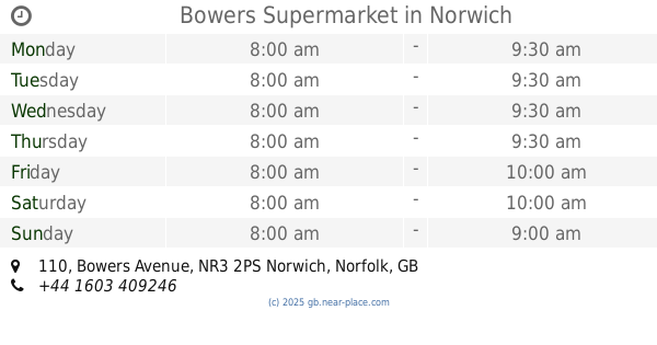
Bowers Supermarket
110 Bowers Avenue, Norwich
Supermarket
read more
10.365 km
The Fresh Network Ltd
Unit 4 Shepheards Close, Aylsham Business Estate, Aylsham, Norwich
Supermarket
read more
10.784 km
Lidl
Drayton Road, Norwich
Supermarket
read more
11.641 km
Tesco Express
45-53 Prince of Wales Road, Norwich
Supermarket
read more
11.665 km
Farmfoods Ltd
67-69 Westwick Street, Norwich
Supermarket
read more
11.795 km
WAW Shop
7-13 Rose Lane, Norwich
Supermarket
read more
11.841 km
Co-op Food
Unit 4, Station Approach, Thorpe Road, Norwich
Supermarket
read more
11.852 km
Tesco Metro
5 Guildhall Hill, Norwich
Supermarket
read more
12.059 km
Morrisons
4 Riverside Road, Norwich
Supermarket
read more
12.086 km
Morrisons
4 Albion Way, Norwich
Supermarket
read more
12.558 km
Lusa Export & Import Ltd
215 Queens Road, Norwich
Supermarket
read more
12.715 km
Plus Ltd
57 Hall Road, Norwich
Supermarket
read more
12.732 km
Tesco Express
79 Grove Road, Norwich
Supermarket
read more
13.274 km
Tesco Express
Tesco Express Earlham, Earlham Road, Norwich
Supermarket
read more
15.153 km
Waitrose
Eaton Centre, Church Lane, Norwich
Supermarket
read more
📑
all categories
Accounting
Administrative area level 1
Administrative area level 2
Airport
Amusement park
Aquarium
Art gallery
Atm
Bakery
Bank
Bar
Beauty salon
Bicycle store
Book store
Bowling alley
Bus station
Cafe
Campground
Car dealer
Car rental
Car repair
Car wash
Casino
Cemetery
Church
City hall
Clothing store
Colloquial area
Convenience store
Courthouse
Dentist
Department store
Doctor
Electrician
Electronics store
Embassy
Establishment
Finance
Fire station
Florist
Food
Funeral home
Furniture store
Gas station
General contractor
Grocery or supermarket
Gym
Hair care
Hardware store
Health
Hindu Temple
Home goods store
Hospital
Insurance agency
Jewelry store
Laundry
Lawyer
Library
Light rail station
Liquor store
Local government office
Locality
Locksmith
Lodging
Meal delivery
Meal takeaway
Mosque
Movie rental
Movie theater
Moving company
Museum
Natural feature
Neighborhood
Night club
Painter
Park
Parking
Pet store
Pharmacy
Physiotherapist
Place of worship
Plumber
Point of interest
Police
Political
Post office
Premise
Real estate agency
Restaurant
Roofing contractor
Route
Rv park, camping
School
Shoe store
Shopping mall
Spa
Stadium
Storage
Store
Subpremise
Subway station
Supermarket
Synagogue
Taxi stand
Train station
Transit station
Travel agency
University
Veterinary care
Zoo
administrative area level 3
administrative area level 4
sublocality level 1
↑