Supermarket nearby Londis Yaxley Broadway Service Station
Coronavirus disease (COVID-19) Situation
confirmed cases
24910387
deaths
232112
United Kingdom
Supermarket nearby Londis Yaxley Broadway Service Station
Londis Yaxley Broadway Service Station
289 Broadway, Yaxley, Peterborough Reino Unido
contacts phone
:
+44
Latitude:
52.5158911
, Longitude:
-0.2686008
read more
nearest Supermarket
792 m
Broadway Superstore
163 Broadway, Yaxley, Peterborough
Supermarket
read more
1.021 km
Rainbow Foodstore
Bentley Avenue, Yaxley, Peterborough
Supermarket
read more
2.456 km
ALDI
Brickburn Close, Peterborough
Supermarket
read more
2.456 km
Aldi
Brickburn Close,Hampton Ctr, Peterborough
Supermarket
read more
2.456 km
ALDI
Hampton Centre, Brickburn Close, Peterborough
Supermarket
read more
2.736 km
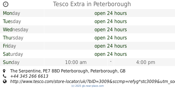
Tesco Extra
Serpentine Green Shopping Centre, The Serpentine, Hampton, Peterborough
Supermarket
read more
2.736 km
Tesco Extra
Serpentine Green Shopping Centre, The Serpentine, Peterborough
Supermarket
read more
2.792 km
Tesco Extra
The Serpentine, Peterborough
Supermarket
read more
3.753 km
Iceland
Ortongate Shopping Centre, Peterborough
Supermarket
read more
3.765 km
Co-op Food & Supermarket, Orton Goldhay, Peterborough
Orton Goldhay, 5 Ortongate Shopping Centre, Peterborough
Supermarket
read more
4.36 km
Westland WH Peterborough
Morley Way, Peterborough
Supermarket
read more
4.747 km
Londis
2-3 Mattley Centre, Peterborough
Supermarket
read more
4.968 km
Morrisons
4 Bellona Drive, Peterborough
Supermarket
read more
5.034 km
Nisa Local and Post Office
126-132 High Street, Fletton, Peterborough
Supermarket
read more
5.085 km
Tesco Express
108-110 Whittlesey Rd, Peterborough, Cambridgeshire
Supermarket
read more
5.215 km
Aldi
Whittlesey Road, Peterborough
Supermarket
read more
5.216 km
Budgens Stores Ltd
Sugar Way, Peterborough
Supermarket
read more
5.321 km
Tesco Express
62 Napier Place, Wistow Way, Orton, Peterborough
Supermarket
read more
5.321 km
Tesco Express
62 Napier Place, Orton Northgate, Peterborough
Supermarket
read more
5.338 km
Premier
The Parade, Lawson Avenue, Peterborough
Supermarket
read more
5.361 km
The Cooperative Foods
60 Lawson Avenue, Peterborough
Supermarket
read more
5.715 km
Nisa Local Thistle Drive
107 Thistle Drive, Stanground, Peterborough
Supermarket
read more
8.271 km
Sprogs Superstore
Bretton Centre, Unit 8, The Cresset, Peterborough
Supermarket
read more
9.731 km
Welland Mini Mart
9-11 Scalford Drive, Peterborough
Supermarket
read more
9.767 km
Londis
33 Peterborough Road, Whittlesey, Peterborough
Supermarket
read more
📑
all categories
Accounting
Administrative area level 1
Administrative area level 2
Airport
Amusement park
Aquarium
Art gallery
Atm
Bakery
Bank
Bar
Beauty salon
Bicycle store
Book store
Bowling alley
Bus station
Cafe
Campground
Car dealer
Car rental
Car repair
Car wash
Casino
Cemetery
Church
City hall
Clothing store
Colloquial area
Convenience store
Courthouse
Dentist
Department store
Doctor
Electrician
Electronics store
Embassy
Establishment
Finance
Fire station
Florist
Food
Funeral home
Furniture store
Gas station
General contractor
Grocery or supermarket
Gym
Hair care
Hardware store
Health
Hindu Temple
Home goods store
Hospital
Insurance agency
Jewelry store
Laundry
Lawyer
Library
Light rail station
Liquor store
Local government office
Locality
Locksmith
Lodging
Meal delivery
Meal takeaway
Mosque
Movie rental
Movie theater
Moving company
Museum
Natural feature
Neighborhood
Night club
Painter
Park
Parking
Pet store
Pharmacy
Physiotherapist
Place of worship
Plumber
Point of interest
Police
Political
Post office
Premise
Real estate agency
Restaurant
Roofing contractor
Route
Rv park, camping
School
Shoe store
Shopping mall
Spa
Stadium
Storage
Store
Subpremise
Subway station
Supermarket
Synagogue
Taxi stand
Train station
Transit station
Travel agency
University
Veterinary care
Zoo
administrative area level 3
administrative area level 4
sublocality level 1
↑