Supermarket nearby Sainsbury's
Coronavirus disease (COVID-19) Situation
confirmed cases
24910387
deaths
232112
United Kingdom
Supermarket nearby Sainsbury's
Sainsbury's
66, Great Cornard, Sudbury Reino Unido
contacts phone
:
+44
Latitude:
52.0367506
, Longitude:
0.7401778
read more
nearest Supermarket
580 m
Waitrose
Station Road, Sudbury
Supermarket
read more
685 m
Iceland Foods
94 North Street, Sudbury
Supermarket
read more
922 m
Aldi
Girling Street, Sudbury
Supermarket
read more
1.897 km
Tesco Superstore
Woodhall Business Park, Springlands Way, Sudbury
Supermarket
read more
12.013 km
Londis
140 Swan Street, Sible Hedingham, Halstead
Supermarket
read more
12.07 km
Darkins Supply Stores D I Y
122 Swan Street, Sible Hedingham, Halstead
Supermarket
read more
12.089 km
Co-op Food
116 Swan Street, Sible Hedingham, Halstead
Supermarket
read more
19.879 km
Argos Colchester Town Centre
2, 17 Long Wyre Street, Colchester
Supermarket
read more
37.754 km
Co-op Food
108 Kings Road, Chelmsford
Supermarket
read more
40.004 km
Tesco Superstore
Princes Road, Chelmsford
Supermarket
read more
41.238 km
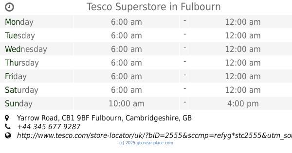
Tesco Superstore
Yarrow Road, Fulbourn, Cambridge
Supermarket
read more
42.877 km
The Co-operative Food
43 High Street, Soham, Ely
Supermarket
read more
43.68 km
Sainsbury's
Brooks Road, Cambridge
Supermarket
read more
45.114 km
Tesco Superstore
Newmarket Road, Cambridge
Supermarket
read more
45.228 km
NIP IN
30 Mill Road, Cambridge
Supermarket
read more
45.438 km
Tesco Express
172 East Road, Cambridge
Supermarket
read more
45.484 km
Sweet Home Chinese Supermarket
31 Burleigh Street, Cambridge
Supermarket
read more
45.696 km
Jiamart Supermarket
69 Regent Street, Cambridge
Supermarket
read more
54.893 km
Tesco Scan As You Shop
15-18 Viking WAY, BAR Hill, Cambridge
Supermarket
read more
55.692 km
Co-op Food & Supermarket, Littleport, Ely
40-42 Wisbech Road, Littleport, Ely
Supermarket
read more
60.443 km
Londis
24-25 Fir Trees, Abridge, Romford
Supermarket
read more
63.768 km
Morrisons
246/250 High Road, Loughton
Supermarket
read more
67.151 km
Bks Food Store
64 High Street, Ilford
Supermarket
read more
67.703 km
Costcutter
284A Clayhall Avenue, Ilford
Supermarket
read more
69.379 km
William supermarket
233 High Road
Supermarket
read more
📑
all categories
Accounting
Administrative area level 1
Administrative area level 2
Airport
Amusement park
Aquarium
Art gallery
Atm
Bakery
Bank
Bar
Beauty salon
Bicycle store
Book store
Bowling alley
Bus station
Cafe
Campground
Car dealer
Car rental
Car repair
Car wash
Casino
Cemetery
Church
City hall
Clothing store
Colloquial area
Convenience store
Courthouse
Dentist
Department store
Doctor
Electrician
Electronics store
Embassy
Establishment
Finance
Fire station
Florist
Food
Funeral home
Furniture store
Gas station
General contractor
Grocery or supermarket
Gym
Hair care
Hardware store
Health
Hindu Temple
Home goods store
Hospital
Insurance agency
Jewelry store
Laundry
Lawyer
Library
Light rail station
Liquor store
Local government office
Locality
Locksmith
Lodging
Meal delivery
Meal takeaway
Mosque
Movie rental
Movie theater
Moving company
Museum
Natural feature
Neighborhood
Night club
Painter
Park
Parking
Pet store
Pharmacy
Physiotherapist
Place of worship
Plumber
Point of interest
Police
Political
Post office
Premise
Real estate agency
Restaurant
Roofing contractor
Route
Rv park, camping
School
Shoe store
Shopping mall
Spa
Stadium
Storage
Store
Subpremise
Subway station
Supermarket
Synagogue
Taxi stand
Train station
Transit station
Travel agency
University
Veterinary care
Zoo
administrative area level 3
administrative area level 4
sublocality level 1
↑