Supermarket nearby SCANWELL
United Kingdom
Supermarket nearby SCANWELL
SCANWELL
3 Amberley Way, Hounslow Zjednoczone Królestwo
contacts phone
:
+44
Latitude:
51.4629045
, Longitude:
-0.3985774
read more
nearest Supermarket
614 m
Tesco Express
Turpin Green Ln, Staines Road, Feltham
Supermarket
read more
614 m
Tesco Express
Staines Rd, Turpin Green Ln, Feltham
Supermarket
read more
742 m
Londis
71 Salisbury Road, Hounslow
Supermarket
read more
778 m
Stainsway Supermarket
493 Staines Road, Hounslow
Supermarket
read more
1.175 km
Tesco Superstore
Dukes Green Avenue, Feltham
Supermarket
read more
1.214 km
Londis
1-3 Central Way, Feltham
Supermarket
read more
1.219 km
Martindale Supermarket
75 Martindale Road, Hounslow
Supermarket
read more
1.361 km
Best Foods
364 Bath Road, Hounslow
Supermarket
read more
1.363 km
Sabzi Mandi Supermarket
356 Legrace Avenue, Hounslow
Supermarket
read more
1.364 km
Sadda Superstore
Bath Road, Hounslow
Supermarket
read more
1.387 km
Iceland Foods
288 Bath Road, Hounslow
Supermarket
read more
1.477 km
Marks & Spencer
2 Burns Way, Cranford Roundabout, Hounslow
Supermarket
read more
1.523 km
Multistar Superstar
2 Nursery Close, Feltham
Supermarket
read more
1.648 km
AFC - Asian Food Centre
177 (Bashir's Parade), 175 Staines Road, Hounslow
Supermarket
read more
1.764 km
AFC - Asian Food Centre
175, 165-177 (Bashir's Parade, 177 Staines Road, Hounslow
Supermarket
read more
1.792 km
Lidl
New Road, Feltham
Supermarket
read more
1.792 km
Lidl
New Road, Feltham, LON-Feltham
Supermarket
read more
1.906 km
Tesco Express
419 Hanworth Rd, Hounslow, Middlesex
Supermarket
read more
1.907 km
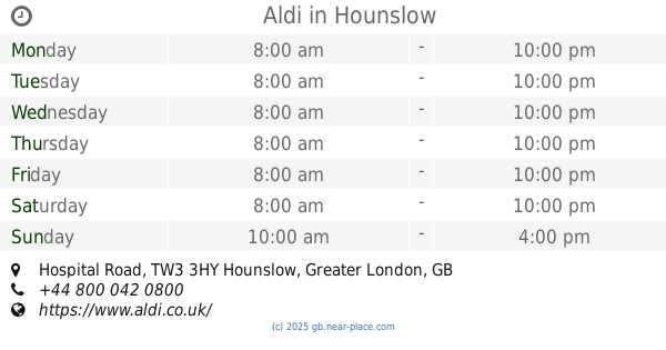
Aldi
Hospital Road, Hounslow
Supermarket
read more
1.989 km
Bajaj Supermarket
720 Bath Road, Hounslow
Supermarket
read more
1.991 km
Home Bargains
Hospital Road, Hounslow
Supermarket
read more
2.001 km
Cranford Supermarket
726 Bath Road, Hounslow
Supermarket
read more
2.027 km
Iceland Foods
10, The Longford Centre, High Street, Feltham
Supermarket
read more
2.042 km
Asda Feltham Superstore
Tilley Road, Feltham
Supermarket
read more
2.158 km
Tesco Express
780-790 Bath Road, Hounslow
Supermarket
read more
📑
all categories
Accounting
Administrative area level 1
Administrative area level 2
Airport
Amusement park
Aquarium
Art gallery
Atm
Bakery
Bank
Bar
Beauty salon
Bicycle store
Book store
Bowling alley
Bus station
Cafe
Campground
Car dealer
Car rental
Car repair
Car wash
Casino
Cemetery
Church
City hall
Clothing store
Colloquial area
Convenience store
Courthouse
Dentist
Department store
Doctor
Electrician
Electronics store
Embassy
Establishment
Finance
Fire station
Florist
Food
Funeral home
Furniture store
Gas station
General contractor
Grocery or supermarket
Gym
Hair care
Hardware store
Health
Hindu Temple
Home goods store
Hospital
Insurance agency
Jewelry store
Laundry
Lawyer
Library
Light rail station
Liquor store
Local government office
Locality
Locksmith
Lodging
Meal delivery
Meal takeaway
Mosque
Movie rental
Movie theater
Moving company
Museum
Natural feature
Neighborhood
Night club
Painter
Park
Parking
Pet store
Pharmacy
Physiotherapist
Place of worship
Plumber
Point of interest
Police
Political
Post office
Premise
Real estate agency
Restaurant
Roofing contractor
Route
Rv park, camping
School
Shoe store
Shopping mall
Spa
Stadium
Storage
Store
Subpremise
Subway station
Supermarket
Synagogue
Taxi stand
Train station
Transit station
Travel agency
University
Veterinary care
Zoo
administrative area level 3
administrative area level 4
sublocality level 1
↑