Supermarket nearby Setara Uk Ltd
United Kingdom
Supermarket nearby Setara Uk Ltd
Setara Uk Ltd
unit 5 mitchells farm 1ee, Gutteridge Lane, Stapleford Abbotts, Romford Det Forenede Kongerige
contacts phone
:
+44
Latitude:
51.635896
, Longitude:
0.1736258
read more
nearest Supermarket
3.926 km
Londis
24-25 Fir Trees, Abridge, Romford
Supermarket
read more
4.607 km
Sangar Trading Ltd
Fowler Road, Ilford
Supermarket
read more
4.819 km
Supermarket
360 Manford Way, Chigwell
Supermarket
read more
5.518 km
Spar
201 Manford Way, Chigwell
Supermarket
read more
5.56 km
Nisa Extra
187 Manford Way, Chigwell
Supermarket
read more
5.57 km
Tesco Express
185 Manford Way, Grange Hill Estate, Chigwell
Supermarket
read more
8.055 km
Asda Chadwell Heath Superstore
Whalebone Lane South, Chadwell Heath, Dagenham
Supermarket
read more
10.054 km
Londis
5 Redbridge Lane East, Ilford
Supermarket
read more
12.54 km
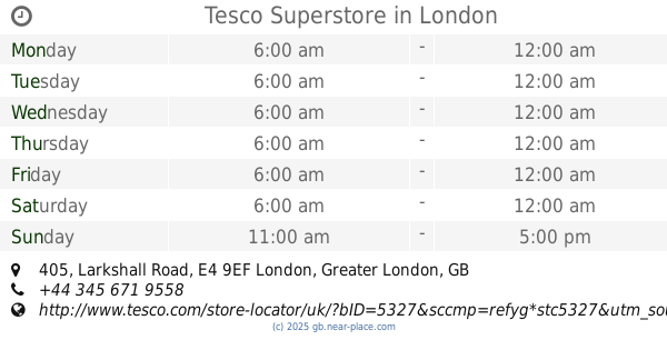
Tesco Superstore
405 Larkshall Road, London
Supermarket
read more
13.068 km
International Food Centre
Romford Road, London
Supermarket
read more
13.852 km
Morrisons
6-7 Salisbury Hall Gardens, London
Supermarket
read more
13.96 km
Esin Cash&Carry
1 Centenary Road, Enfield
Supermarket
read more
14.141 km
Tesco Express
567 569 High Rd, Leytonstone, London
Supermarket
read more
14.182 km
M K Bros Halal Butcher & Grocer
30 Woodgrange Road, London
Supermarket
read more
14.671 km
Singh Supermarket
262 High Road Leytonstone, London
Supermarket
read more
14.797 km
Lidl Depot Enfield
67 Ardra Road, London
Supermarket
read more
14.91 km
Asda Walthamstow Supermarket
Walthamstow, 19 Selborne Walk Shopping Centre, London
Supermarket
read more
15.092 km
Iceland Foods
1 Joyce Dawson Way, London
Supermarket
read more
15.278 km
Rodi Supermarket
168 Queens Road, London
Supermarket
read more
15.508 km
International Supermarket
15-17 High Street, London
Supermarket
read more
15.862 km
Market Village at Stratford Shopping Centre
Stratford Centre The Mall 70-73 The Mall Stratford shopping centre, London
Supermarket
read more
16.141 km
Londis
11 Allhallows Road, London
Supermarket
read more
18.505 km
Tesco Express
114-116 Violet Road, London
Supermarket
read more
18.951 km
Iceland Foods
10 Vesey Path, London
Supermarket
read more
19.138 km
Mile End Food & Wine London
93 Burdett Road, London
Supermarket
read more
📑
all categories
Accounting
Administrative area level 1
Administrative area level 2
Airport
Amusement park
Aquarium
Art gallery
Atm
Bakery
Bank
Bar
Beauty salon
Bicycle store
Book store
Bowling alley
Bus station
Cafe
Campground
Car dealer
Car rental
Car repair
Car wash
Casino
Cemetery
Church
City hall
Clothing store
Colloquial area
Convenience store
Courthouse
Dentist
Department store
Doctor
Electrician
Electronics store
Embassy
Establishment
Finance
Fire station
Florist
Food
Funeral home
Furniture store
Gas station
General contractor
Grocery or supermarket
Gym
Hair care
Hardware store
Health
Hindu Temple
Home goods store
Hospital
Insurance agency
Jewelry store
Laundry
Lawyer
Library
Light rail station
Liquor store
Local government office
Locality
Locksmith
Lodging
Meal delivery
Meal takeaway
Mosque
Movie rental
Movie theater
Moving company
Museum
Natural feature
Neighborhood
Night club
Painter
Park
Parking
Pet store
Pharmacy
Physiotherapist
Place of worship
Plumber
Point of interest
Police
Political
Post office
Premise
Real estate agency
Restaurant
Roofing contractor
Route
Rv park, camping
School
Shoe store
Shopping mall
Spa
Stadium
Storage
Store
Subpremise
Subway station
Supermarket
Synagogue
Taxi stand
Train station
Transit station
Travel agency
University
Veterinary care
Zoo
administrative area level 3
administrative area level 4
sublocality level 1
↑